Andrei Stepanenko
February 01, 2020 <https://scan1707.blogspot.com/2020/02/3-29012020.html>
Translated by Berenkova Violetta Michailovna
February 01, 2020 <https://scan1707.blogspot.com/2020/02/3-29012020.html>
Translated by Berenkova Violetta Michailovna
CONSIDERING THE CATASTROPHIC CRASH, WE POINT OUT THE MECHANISMS.
Basic materials
Stages of the comet catastrophic crashes:
http://the-small-joys.blogspot.ru/2017/03/25032017_25.html
Addition material to the post concerning the stages:
http://the-small-joys.blogspot.ru/2018/02/02-2018.html
Stages of the comet catastrophic crashes:
http://the-small-joys.blogspot.ru/2017/03/25032017_25.html
Addition material to the post concerning the stages:
http://the-small-joys.blogspot.ru/2018/02/02-2018.html
On behalf of everyone who has brought the contribution: adventure6, alexsoff, andrew-vdd, ar-k-om, bioplant, Brusek Kodluch, bgrusnak, bskamalov, chispa1707, Чумакин М. М., cladovschik, coralsteel, curiousmole, despaminator, dmitriy_ukhlinov, evan-gcrm, fantastron1, jarnikov45, grnsta, Joe Doe, istbat, It4history, is3, kiseitch, kronsh, leonid-smetanin, muha-vchocolate, mygellanov, olegs4erbinin, paomako, papa-fittih, plamyaognya, radmirkilmatov, rodom-iz-tiflis, samarka-14, sergiusjs, sibved, Александр Перевознюк, Борис Бондарчик, Валера Полевой, Виктор Давыдов, Женя Разуваев, Падре-Адриан Банкельс, Хуповой Владимир Валентинович, Эпоха Недоверия, Alexander Rovny., Alexus Petrov, Andrey Melnik, Andrey Pedko, Andrii Goretskyi, Flonzcraft, Hennadii Brezynskyi, Ilya Mazo, Ilya Nikitin, JAUHIEN HRYBOUSKI, Murgab, Nikolay Luchkin, Александр Александрович В., Александр Ахмедович М., Александр Викторович П., Александр Владимирович Б., Александр Владимирович К., Александр Вячеславович К., Александр З., Александр Иванович М., Александр Игоревич З., Александр Николаевич П., Александр Сергеевич П., Александр Чулков, Александр Шахлай, Алексей Андреевич К., Алексей Владимирович У., Алексей Иванович Г., Алексей Николаевич С., Алексей Олегович С., Алексей Сергеевич Г., Алексей Сергеевич Р., Алексей Юрьевич Б., Анатолий Анатольевич Я., Андрей Владимирович Б., Анна Александровна Б., Антон Александрович Т., Богдан Александрович О., Вадим Владимирович К., Вадим Юрьевич К., Валерий Александрович К., Валерий Владимирович Х., Валерий Игнатьевич Климовец, Валерий Михайлович Б., Валерий Павлович Н., Виктор Вениаминович Л., Виктор Сергеевич Л., Виктор Юрьевич Д., Виталий Николаевич К., Владимир Владимирович Ф., Вячеслав Вадимович М., Григорий Андреевич Г., Григорий Викторович П., Дмитрий Владимирович Н., Дмитрий Владимирович Ш., Евгений Николаевич Д., Евгений Панченко, Евгения Николаевна П., Егор Борисович К., Елена Анатольевна Т., Елена Евгеньевна Д., Елена Эриковна К., Елена Юрьевна Ж., Иван Владимирович Ш., Иван Иванович К., Иван Николаевич К., Иван Николаевич С., Игорь Иванович К., Игорь Николаевич С., Игорь Олегович И., Ильдар Ишалин, Ильдар Рамилевич Х., Ирина Вильевна К., Ирина Петровна В., Людмила Александровна Г., Максим Анатольевич С., Максим Борисович С., Марина Валерьевна Г., Мария Александровна Д., Матвей Александрович Ч., Михаил Германович М., Михаил Георгиевич С., Наталья Валерьевна С., Николай Андреевич П., Олег Александрович Г., Олег Павлович Ц., Ольга Евгеньевна Л., Ольга Юрьевна О., Павел Александрович Ц., Павел Александрович Ц., Павел Михайлович К., Падалко Андрей, Радмир Вакильевич К., Рамиль Рушанович К., Ранис Наилевич И., Роман Владимирович М., Роман Владимирович С., Роман Николаевич Г., Роман Патрикович И., Руслан Равилевич З., Рустам Вугарович А., Светлана Владимировна М., Светлана Геннадьевна Ф., Сергей Александрович Ф., Сергей Васильевич К., Сергей Викторович С., Сергей Иванович Л., Сергей Л., Сергей Михайлович Л., Сергей Петрович Р., Сергей Х., Сулхан Тамазович Д., Тагир Кимович А., Татьяна Вячеславовна У., Татьяна Николаевна Т., Тимур Аристанбаев, Тимур Исмаилович Д., Юрий Николаевич Г., Неизвестный (27.02.2020 01:56),
The concept of interdisciplinary connections is not specified unequivocally, however distinguishing of those connections has allowed uniting certain scientific theories explaining:
- Character of interaction of the Earth and large meteoric bodies;
- Displacement of an axis of the Earth rotation;
- Displacement of rotational tension in tectonosphere;
- Transgressions and regressions of the seas;
- Permafrost origin;
- Origin of some coal-fields and oil deposits;
- Death of pleistocene megafauna;
- Neolithic revolution.
TECTOGENESIS. THE THEORY
Transgressions and regressions of the seas and formation of tectonic fault lines have one general origin. First of all, here are some extracts from the textbook.
1.1. DISPLACEMENT OF THE AXIS AND PRESSURE IN TECTONOSPHERE
Fig. 1. The scheme of origin and a discharge of pressure in tectonosphere at the expense of change of position of the Earth rotation axis concerning its surface [1].

1.2. THE SOURCE OF TECTOGENESIS FORCES
Change of position of the rotation axis in the Earth body brings the basic contribution in the field of rotational tension (|99 percentage of the necessary for starting of tectonic the Earth activation). These tensions can reach the critical values equal to the ultimate strength of tectonosphere rocks (107 pascals), i.e. it is a real source of the Earth tectogenesis forces [2].
1.3. DEFORMATION OF GEOID
Change of position of the Earth body rotation axis leads to synchronous deformation of geoid, appearing, first of all, in the change of the World Ocean level: in the points of the terrestrial surface which removed nearer to the poles, the ocean level goes down; in the points which move off the poles, it raises [3]. There is a basis to expect similar reaction of the solid floor of the ocean to the same change of the position of the Earth rotation axis. Land heights change accordingly.
1.4. EFFECT OF SCREWING
Transgressions and regression es of the seas depend not only on displacement of the Earth rotation axis, but also on deformations of continental plates and the ocean floor. In the latter case, transgressions and regression es in relation to the coast are unequal. A good example - transgression of the Littorina (Baltic) Sea:
- In Blekinge - 8 metres;
- In Straits of Öresund and Store Bælt - 10 metres;
- In the southwest part of the basin - 15 metres;
- Around the Gulf of Danzig - 13 metres;
- In the northern part of the Gulf of Finland - 4 metres;
- In the territory of St.-Petersburg - 7 metres [4].
The effect is explained by different degree of forces of pressure and tension arising synchronously with displacement an axis of rotation - depending on remoteness of the sites of the crust from meridians of the maximum displacement. As a result, the sites «are screwed», and deposits on the basin coast evidence it. The coastal line of the Yoldia Sea screwed as well.
Fig. 2. Depth of the coastal line of the Yoldia Sea[5].

1.5. CRUST FAULTS
Faults arise in the place of faults and replace screwing there where to fault a plate along a fault is easier, than to screw.
Fig. 3. Piqiang Fault, the People’s Republic of China (Takla Makan) [6].

1.6. SYSTEM OF FAULTS
As rotational tension can reach the critical values equal to ultimate stress of tectonosphere rocks (107 Pascals), there may be series of faults. The first system of faults becomes a command: in case of further movement of the axis, new tensions are inclined to discharge in the already fixed system in the form of faults. That is, the system of faults existing for today unidirectional because it reflects the initial phase of the rotation axis displacement.
Fig. 4. The scheme of the arrangement of the system of faults indicators (Ukraine) [7].

2.1. ORIENTATION OF FAULTS
General orientation of the majority of lineaments in Eurasia indicates to Greenland, and some part - to the present geographical pole. As the system of faults is laid at the very beginning of the displacement of the Earth rotation axis, there were two large acts of displacement, and it is necessary to search for the previous northern geographical pole in Greenland.
Fig. 5. The scheme of lineaments in Eurasia [8].

2.2. THE PREVIOUS POSITION OF THE POLE
The previous position of northern geographical pole is indicated by not only lineaments, but also by the relic zones of boreal and wood type soils. At first, here is the map of soil zones as it is.
Fig. 6. V. Dokuchayev. Soil zones of the Northern hemisphere 1899 [9].

Now here is a fragment of the same map with the pointed out and perfectly differentiated two zones - relic and modern - for each of two types of soils.
Fig. 7. A fragment of the map by V. Dokuchayev. Soil zones of the Northern hemisphere [9].

There are no intermediate zones that indicates the fast enough displacement of northern geographical pole in the terms of geological measures. There are no the zones as well reflecting other position (forthcoming the Greenland one) of the northern geographical pole that indicates a very long steady position of the geographical pole in Greenland.
2.3. DATING OF DISPLACEMENT OF THE EARTH ROTATION AXIS
Now we are going to compare two maps: with the displacement of soil zones and with habitat and death of mammoths. The territories confidently coincide. It means that mammoths in the course of extinction moved to the south after the displacement of the climatic zones.
Fig. 8. Displacement of soil zones [9] and habitat and death of mammoths [10].

As a species, mammoths prospered here for 1.5 million years, and chronological frameworks of extinction of mammoths: 14-10 thousand years ago. It is the ending of stability and the beginning of the epoch of the axis displacement, and climatic and soil zones at the same time. Almost synchronously with the extinction start, 15 thousand years ago transgressions and regressions of the forming Baltic, Caspian and Black Seas began - in strict conformity with the citations from the textbook presented above.
2.4. PEAK OF CHANGES
Taking into consideration that the displacement of the Earth rotation axis is accompanied by the synchronous deformation of geoid, so, both synchronous transgressions and regression es of basins, it is necessary to pay attention to the period of about 8200 years ago. Neither in pleistocene, nor in holocene there was no other period with such high density of dramatic tectonic events.
8000 years ago - ocean regression for 14 metres
8000 years ago - the New Caspian transgression
8000 years ago - the Black Sea flood
8200 years ago - Storegga Slide
8200 years ago - flooding of Doggerland
8200 years ago - Lake Agassiz fault
8200 years ago - stop of Gulf Stream
8200 years ago - displacement of the floating ice border to the south
8200 years ago - transgression of the world ocean
8200 years ago - flooding Sunderland (Indonesia-Indochina)
8200 years ago - flooding of Sahulend (Australia, New Guinea)
8250 years ago - transgression on the Aleutian Islands
8300 years ago - oceanic species of fauna in the Baltic Sea
8500 years ago - the Littorina Sea
10000 years ago - flooding of Beringia, the penultimate stage
The flooding of Beringia is different: the penultimate stage of the flooding is dated 10 thousand years ago, but they usually avoid dating of the last, uppermost sea terrace. In such situation, the total flooding of Beringia 8200 years ago is an acceptable assumption.
After the point 8200 years ago, the following fluctuations of the world ocean level are: transgression - 7200-6500 years ago, regression - 6500-5000 years ago, transgression - 5000-4500, regression - around 4500, transgression - 4500-4000, regression - 4000-3800, transgression - 3800-3700, regression - 3700-2500, transgression - 2500-1500 years ago, regression - 1500 years ago till nowadays [11]. That is, it is possible to consider the period of 15-14 thousand years ago as the incident beginning as a whole, the date 8200 years ago – the peak of the displacement of the Earth rotation axis, and the period after the point 8200 years ago - the period of stabilization of the planet.
2.5. DISPLACEMENT OF SOIL ZONES AND PERMAFROST
Permafrost is the most obvious natural phenomenon organically connected with the death of the pleistocene megafauna, thus, with displacement of soil zones. Moreover, the frozen subsoil territory has the form of a drop with the geometrical centre lying on the same straight line, as the vector of the displacement of the Earth rotation axis. If the geometrical centre of the frozen subsoil and the former geographical pole had pulled in its side, the present pole would have been the correct compromise.
Fig. 9. Displacement of soil zones [9] and permafrost [12].

2.6. PERMAFROST AND GLACIATION
Permafrost and glaciation connection - long decrease in average temperatures when the ground continues to freeze deep through, and thaws only in the surface – is also admitted. Research of an isotope composition of ice has shown that 18-20 thousand years ago average temperatures of January in the north of Yakutia were 25°С, and in the central Yakutia, 15-20°С lower, than today [13]. It equalises the climate of Yakutia of the epoch of mammoths flowering and the present Antarctic climate. The frozen subsoil can remain, the 2.7 km thick ice layer in the area of Taimyr can remain and accrue in the thickness, but forage reserve for the pleistocene megafauna could hardly remain.
There is also an addition to this contradiction. William Patterson from the Canadian university of Saskatchewan has studied patterns of deposits with the step of 0.5 mm from Lake Lough Monreagh in Ireland. The isotope analysis has shown that the glaciation occurred during half-a-year period, and thus all living, including plants, died [14]. It was not a long cooling, it was biosphere catastrophic crash, and it was momentary, in evolutionary term.
Both researches are unconditionally correct: these characteristic for low temperatures isotopes are present in the ice and in deposits, contemporary to the pleistocene megafauna; there is lack of interdisciplinary logic connections explaining the paradox.
Moreover, it is important to remember here that all great glaciations coincided with the largest rock-building epochs when the relief of the terrestrial surface was the most contrast, and the area of the seas decreased [15]. Attempts to match this observation to the present (the average height of mountains and contrast of the relief has become even more considerable) have failed. The conclusion: the mountains are not the point, but the process of rock-building should be taken into consideration, connected first of all with the change of the Earth rotation axis.
There is also certain connection of glaciation with the activity of volcanoes, here again there is also lack of interdisciplinary logic connections. In paleogene volcanoes were active, and there were almost no glaciers. The reason: the activity of volcanoes and glaciation process should coincide, first of all, during the displacement of the Earth rotation axis.
The founding fathers of the glaciation theory Louis Agassiz and James Kroll directly bound coming of the Ice Age to the change of the Earth rotation axis, but for the lack of interdisciplinary logic connections they predictably slipped to obviously secondary climatic factors - less light and long cooling.
2.7. GLACIATION AND METEORITES
The basic message of idea to connect meteorites and glaciation is clear: too high speed of glaciation. Even those 10 years that are given for glaciation at present, are not enough for creation with the help of climatic factors of essentially different geological epoch - with moraines, rock-building and glaciers with thickness of up to 4 km. Meteorites are able not only to eclipse the Sun with explosions dust, but also possess energy, sufficient for creating of rather radical changes in the landscape of all planet. There is only one problem: there is no any model; the blow of the necessary force can destroy the planet, and cannot create a clear picture of complex geological evolution.
2.8. SUMMARIZE OBVIOUS FACTS
1. The Earth rotation axis passed earlier through the centre of Greenland, and that position remained invariable, at least, from the moment of occurrence of mammoths, that is, 1.5 million years running. It evidences extreme stability of the planet and the unique character of the axis displacement.
2. Displacement of the Earth rotation axis, appearance of the system of faults, screwing of the planet surface and sea-bed areas, transgression and regression of the seas and oceans have one nature and one not yet indicated cause.
3. The unindicated original cause of the coming tectonic events is dated as the beginning of the death of mammoths and the beginning of the end of the Ice Age14-15 thousand years ago.
4. The existing tectonic fault lines is mostly laid at the initial stage of the Earth rotation axis displacement, therefore lineaments are directed mainly to the centre of Greenland.
5. The peak of tectonic motions was 8200 years ago and so it is necessary to date lineaments, directed towards Greenland.
6. Ten transgressions and regressions after that 8200 years ago time point should be ascribed to the stage of stabilization of the planet condition.
7. The Earth rotation axis was displaced approximately for 17 ° in the direction of longitude from 40 to 140.
8. Absence of intermediate soil zones indicates on extremely fast by geological measures displacement of the Earth rotation axis to the present position.
9. Last large tectonic motions occurred in the position of the poles very close the modern one, what the lineaments evidence with their direction at the present pole.
10. Permafrost formation is connected, first of all, with the displacement of the Earth rotation axis, rapid rock-building and volcanic activity.
11. Permafrost formation is connected with the end of the Ice Age, even if it seems paradoxical.
12. The end of the Ice Age is directly connected with extinction of the pleistocene fauna; that is the official position of modern science.
13. Climate fluctuations, change of climatic zones, movements of monsoons and trade winds, warm and cold currents, global desertification and bogging are the consequence of the Earth rotation axis displacement and accompanying them tectonic processes, but they are not their cause.
2.9. SAFE EXTENSION
Sometimes extension of the planet is pointed as the reason of global catastrophic crashes, the process not recognised by the science [16]. However variations of angular speed bring in the field of rotational tension extremely small contribution - (|1 %), that is, the extension of the planet basing on tectogenesis theory is safe.
2.10. SECURE THAWING OF GLACIERS
Hypotheses of influence of glaciers’ increase and thawing on characteristics of the planet rotation regular arise [17], however, it can lead only to precession change and to variations of angular velocity, that is, changes in the ocean levels are hardly possible. Acknowledgement is as follows: 1.5 million years of mammoths’ prosperity in the same climatic zone, despite of all described glaciation and warming processes.
THE ELECTRIC DISCHARGE. THE THEORY
3.1. NUANCES OF THE ORIGINAL CAUSE MISSING
Displacement of the Earth rotation axis can be caused only by change of distribution of masses in the planet bowels. Here is a good citation: “Cumulative action of gravitational and adhesive forces of the planet substance determining its durability and described above exogenous processes, as a result, the surface of the Earth should form regular ellipsoid of revolution - an ideal figure of a rotating body balance. What does actually occur? We see considerable deviations from this form, reaching values of an about ±10 km» [18].
It means that in bowels there forces creating not ideal form of geoid, and if the surface has not formed ideal ellipsoid outside, the cause of it is in bowels.
Thus, bowels are obviously inclined to stability: 1.wzz5 million years mammoths prospered in one invariable climatic zone. The rotation axis moved for 17 °, during 6 thousand years maximum - scanty term, geologically speaking, and the latest cooling occurred just in half a year. It is a catastrophic crash, there must be some source influencing the bowels. There is source.
3.2. THE PUBLICATION BY A. P. NEVSKIY
In 1978 “The Astronomical Bulletin” (volume 12, № 4) published the article by A. P. Nevskiy “The phenomenon of the positive stabilized electric charge and effect of electric discharge explosion of large meteoric bodies in flight in the atmospheres of planets” [19]. For public the essence of the article was rewritten, without formulas, in the magazine “Technics – for the youth” 1987-12, in the magazine “The Earth and the Universe” 1990-3 and in A. Voitsekhovsky's interview [20].
* Nevskiy Alexander Platonovich (1935-2005), Cand. Sc. (Physics and Mathematics), the leading research assistant, TsNIIMash, Russian Aerospace Agency
3.3. EFFECT OF ELECTRIC DISCHARGE EXPLOSION ACCORDING TO A. P. NEVSKIY
An electric dipole is formed in a comet with the concentrated positive charge on the surface and scattered negative charge in a plasma tail. The positive charge is stabilized and reaches considerable value. In case of close passing, there appears huge potential difference between the comet and the Earth, which can lead to air layer breakdown. Under standard conditions, the super-power multichannel discharge begins already from the height of 25 kilometres.
Prior breakdown electric fields cause electrostatic levitation, which explains the phenomenon of elevating of large subjects in the air observed in practice (trees, yurtas, soil sites on hills). There is extremely strong light flash, and there where the soil is damp, corona discharge appears.
There are hundreds of thousands of breakdown channels, they result in rigid x-ray radiation, and neutron radiation as the result of reaction of deuterium nuclear synthesis.
Electric discharge high-rise explosion leads to destruction of the meteorite with transformation of its part into vaporous and dust conditions. The meteorite blows up from the bottom side [21; 22], therefore it or its large splinters receive a powerful impulse to the direction from the Earth surface.
There are three shock waves. The first shock wave is product of energy release in a lightning column. The second - explosive destruction of the meteoric body. The third - a ballistic wave resulting from supersonic intrusion of the meteoric body into the atmosphere.
Spreading of currents along water-bearing layers heats water up to formation of boiling reservoirs and huge geysers.
3.4. CONFIRMATION BY PRACTICE OF SPACE FLIGHTS
Theory by A.P. Nevskiy appeared as a result of struggle against plasma shielding of radio-waves of going down spacecrafts (SC), thus it is based on extremely specific practice. Interaction of the Earth and SC really goes under the scheme described in the theory, up to explosions [23].
Fig. 10. Composition of technogenic objects in low-Earth orbits[23]

Sometimes SC are blown up deliberately (India, 2019), but other explosions are admitted as "casual" ones, but, as a whole, fragments of the spacecrafts destroyed by explosions are threat № 1 for all those flying in space.
Fig. 11. The project of dangerous objects removal from near-Earth orbits [23]

3.5. CRITICISM OF THE A. P.NEVSKIY’S THEORY
Basically, nobody criticizes the theory due to its good validity. Critics reject [24; 25; 26] only formula № 22 (V = dV*R/D), which A. P. Nevskiy used for calculation of difference of potentials between the meteoroid and the Earth surface. Because of space velocity of the meteoroid, this difference is of space scale too.
It does not suit the opponents replacing the high-speed object in A. P.Nevsky’s model by a static condenser with almost zero energy or a Christmas-tree decoration wrapped up with foil and successfully proving that this model is incorrect.
3.6. UNKNOWN FACTS ABOUT METEOROIDS
The problem with the formula № 22 could be solved, if we knew self positive charge (before entering into the atmosphere) of the meteoroid, but such data are absent.
Diameter of the visible part of the comet coma can reach millions of kilometres. This coma is strictly spherical and is not rumpled under the pressure of the solar wind that indicates that the solid body of the comet has its own centrosymmetrical positive electric field [27], strong enough to resist to the solar wind and to keep the spherical form of the coma of the enormous sizes.
Meteoroids of the comets differ only in their size and quantity: for comets the usual indicated weight is from 0.1 to 1 million tons, and for the shower of Perseids - 10-100 thousand times more [28]. Obviously the positive charge of the bodies of such shower does not become less because of that the coma and tails of single meteors are not visible via a telescope.
It is difficult to estimate the charge of a meteoric shower, for example, according to its weight: for multielectronic atom, there are concepts of the second, third and etc. ionization potentials. For argon energy of consecutive ionization I1 and I7 differs 8 times, and for sulphur - in 27 times [29]. So, if the Tungus meteorite made the water of underground layers boil and break upward as geysers, the question is - what the shower of several millions of such bodies could do?
3.7. SCIENTIFIC CONFIRMATION
In 2017, two news appeared in press [30, 31] about the discovery made by the Russian science: lightnings really appear between meteoroids and planets with extremely serious consequences - up to kimberlite pipes formation. The theory by A.P. Nevskiy is fully confirmed.
3.8 COMPREHENSIBLE GROUP OF COMETS
There is also a group of comets suitable for the discussed case with a period of about 7 years (it is approximated to integer numbers); there are 109 of such comets from the total number of 530 comets that is 20.6 % from all periodic comets specified in Wikipedia [32]. Powerful burst observed in the chart can’t be regarded as accidental.
Fig. 12. Number of comets in groups with a different period (it is approximated to integer numbers of years)

The brightest representative of this group is swastika-type Biela’s Comet with a period of 6.749 years, for this reason, along with the Sun, the swastika - a symbol of lethal power – is the most persuasive space motive of tribal ornaments.
Fig. 13. The swastika-type Biela’s Comet [33]

Total 86 (16.2 %) periodic comets have the period divergent from the calculated period of Biela’s Comet (6.749) for no more than 5 %. Statistically it is one group.
The most of these comets cross the orbit of the Earth rotation round the Sun that it is also impossible to consider as accident. It even gives basis for the conclusion about the origin of all these comets near to the mother Earth [34], and it is not deprived of sense. If the bundle of the comet bodies was caught by the Earth gravitation and, moving to the Earth, some its parts were exposed to identical high-rise electric discharge on different sites of the planet round the Sun orbit, the result should be as follows: bulk of formally not linked comets with the similar period, crossing the mother Earth orbit on its different sites.
Fig. 14. Orbits of comets 104P/Kowal and 8P/Turtle [35; 36]

Similar comet bundles were also definitely captures by the Venus, - there were more than 30 observations of the Venus satellites registered by at least 12 astronomers totally [37], and the destiny of these "satellites" is obliged to be similar: shooting by high-rise electric discharge and moving into space on a new trajectory and burning of the residuals in the atmosphere, therefore in 1855 the Venus shone over the USA in the middle of a sunny day [38].
Let's match the consequences of the electric discharge and tectogenesis as result.
THE ELECTRIC DISCHARGE AND TECTOGENESIS. SYNTHESIS
4.1. THE KEY METEORIC FACTOR
The electric discharge makes the Earth a cathode, and the meteoric shower passing around – an anode, therefore lightnings in such contact stike from below upwards [20]. Judging by the behaviour of the lightnings striking upwards [21], atmosphere is the first to react to threat, then the underlaying layer (oceans and the crust), and only then the planet entirely. The Earth-cathode loses electrons and warm in large quantities, and meteoric bodies acquire electrons and warm, that leads to their explosive destruction .
4.2. SELECTIVITY OF THE ELECTRIC DISCHARGE
The electric discharge chooses the shortest ways - to the greatest charge and with the least resistance of the environment. For this reason, the lightnings from below first choose the most charged space objects. On the other hand, conductivity of bowels depends on the character of faults, and composition of the mineralized waters layers, therefore the discharge moves along the most vulnerable due to tectonic consequences zones of the Earth.
4.3. DEFENSIVE SYSTEM OF THE PLANET
Electrical discharges moving with space velocity liquidate the most part of threat pointwise: the most dangerous meteorites blow up, at that, from the bottom side, and most of them do not reach the surface of the planet.
4.4. THE MOST EVIDENT CONSEQUENCE OF THE ELECTRIC DISCHARGE
When the Earth-cathode gives its electrons, elements in oceans and bowels are ionized, and this process is endothermic [39], that is, goes with heat removal. The acute shortage of electrons starts the whole series of geochemical processes, and almost all these processes are endothermic as well. The most evident consequence of the electric discharge is permafrost. Ionization reaction goes with almost momentary removal of heat in all bulk of rocks, especially in the electric discharge zone. Thus, the glaciation of mammoths proceeding faster and more effectively, than in freezer chests of meat processing and packing factories, finds its simple explanation.
4.5. CHILLING OF THE ATMOSPHERE AND OCEANS
The strongest ionization happens with the second after oxygen prevalent element on the earth - hydrogen. The atmosphere and ocean are cooled at once, without long climatic factors that explains paradox of fast glaciation [14]. There appear the isotopes indicating extremely low temperature [13], impossible for these climatic zones.
5.1. THE CONDITION OF DISPLACEMENT OF THE EARTH ROTATION AXIS
After the electric discharge, it is necessary to expect high concentration of opposite charged ions on the different sides of the geoid with an axis passing through the geometrical centre of the electric influence on the Arctic regions. It is approximately 34 ° from the old pole in the centre of Greenland or 17 ° from the new pole towards longitude 140. That is, electric polarization of the geoid has been compulsorily displaced, and between these new electric poles, there were new, differently directed interacting forces and the plane of electric balance displaced concerning the equatorial plane. New geochemical processes, focal change of magma density will begin; therefore the bowels bulk, and together with them and the Earth rotation axis, will start to displace.
Fig. 15. New electric balance of the planet bowels

5.2. DIGRESSION OF THE MAGNETIC FIELD OF THE EARTH
The situation of the electric disbalance of the planet as the reason of inversion of the magnetic field looks ideal. However, even for the short-term digression of the magnetic field of the Earth going on by different estimations from 4 [40] till 250 years, it is required to change the rotation direction - either of the Earth or theoretical "geodynamo" in its core.
Without the application of additional energy only Dzhanibekov’s effect of is able to change the direction of the planet rotation: after overturn, the Sun ascends in the west and moves in the opposite direction absolutely organically. As a result, orientation of the magnetic field of the Earth concerning the pole changes, and concerning the Solar system remains to the same.
5.3. DZHANIBEKOV’S EFFECT AND THE EARTH
Dzhanibekov’s effect is absolutely safe to apply it to the Earth owing to dynamic balance: the carriage of a roller coaster turns over too, but nobody drops out. Formula Rossa roller coaster have speed of 241 km/hour. A person on the equator moves round the axis 7 times faster, and the Earth flies forward with the speed of 107 thousand km per hour that is 445 times faster than the carriage. The Earth will turn over, as a single whole, and the gapers will not even spill their coffee out of a paper cup.
The change of familiar parts of the world is safe too. If the carriage also rotates, in the top part of a circular way the Sun will rise for the passenger on one side, and in the bottom – on the other. Change of the parts of the world in the process of overturn of the Earth according to Dzhanibekov is not the conflict of forces, but their mechanic continuation.
There were four dated annalistic evidences identifying such overturn (suspension of the visible Sun movement) - in 1123, 1391, 1547 and 1683. The Direct consequence is earthquakes, severe frosts and drying up of the rivers during the following and the next two years in all cases. The tsunamis did not happen, there was only one inundation. Planet overturn is safe in itself and in the proximate consequences. The difficult place is obligatory change of the flows direction, but they seem to pass without great problems: fleet in those key three years did not sink, and overturn cities were not flooded.
5.4. CONDITIONS FOR OVERTURN
Wikipedia about Dzhanibekov’s effect writes the following: the theorem of the tennis racket is … a consequence of laws of the classical mechanics describing movement of a firm body with three various main inertia moments [41].
WHAT IS “INERTIA MOMENT”
The inertia moment is … an inertia measure in a rotary motion round an axis. Each body has three moments of inertia, and each of them is related to the main central axis of inertia. Each of these three axes passes through the center of mass and coincides with the possible axis of rotation.
In figure below relative to axis AA, cylinder "C" has the least moment of inertia, and cylinder "B" - the greatest.
Fig. 16. The least and greatest moments of inertia

In fig. 13.2. the body with three moments of inertia is shown. Relative to the main central axis of inertia “A” the inertia moment has the least value; relative to “B” axis – intermediate value, and relative to “C” axis - the least. Rotation of the body round “B” axis will be unstable.
Fig. 17. The main central axes of inertia

The Earth is a little flattened from the poles rotates round the axis with the greatest moment of inertia as well. Two axes with the least moment of inertia which are perpendicular to it lie in the equator plane and are equal to each other that makes rotation steady.
5.5. APPLICATION OF DZHANIBEKOV’S EFFECT TO THE PLANET
For realization of Dzhanibekov’s effect three main axes and rotation of the Earth round its axis with the intermediate (not the greatest and not the least) moment of inertia [41] are required. The condition is executable in one and the only, exclusively rare case - as the result of displacement of the planet center of mass.
Emergence of two displaced maxima of bowels ionization relative to poles for 34 ° also changed local magma density and behaviour that displaced the center of mass as well. When the center of the planet mass changed the direction of all three main central axes of inertia also exchanged. Two axes passing through the equator lost the accordant position, and their moments of inertia definitely ceased to be equal that, at least, led to instability of rotation.
As geoid has a sphere-like form (deviation of 15 km in height or 0.2 % from the planet radius), the difference between three moments of inertia is insignificant, and the situation in which the axis of inertia passing through the geographical poles, acquires intermediate value of the moment of inertia, becomes real. The fact of displacement of soil zones for 17 ° specifies that such geological changes certainly occurred in the past.
Hardly the Earth rotation axis acquires intermediate value, the main condition for planet overturn according to Dzhanibekov is satisfied.
5.6. PLANET REHABILITATION
There are two unresolved questions:
- whether the intermediate moment of inertia remained relative to the Earth rotation axis during all time of overturns or it periodically accepted the greatest values;
- how quickly and coinciding with overturns and values of the moments of inertia the axis of rotation of a planet was displaced.
However, there is also a reliable constant.
The end of overturns is definitely connected with displacement of the Earth rotation axis for 17 ° - to its present position where the planet appropriately rotates round its axis with the greatest moment of inertia, and two least moments of inertia are equal again.
Fig. 18. Displacement of the Earth rotation axis as summary result of overturns according to Dzhanibekov

5.7. THE BASIC CONNECTED EVENTS
There were three closely connected basic events. Three dramatic interdependent events proceed within the limits of a uniform process and without the application of additional energy:
- Displacement of the Earth rotation axis;
- Overturn of the Earth according to Dzhanibekov;
- Digression of the magnetic field of the Earth.
The main difference of the planet from the screw nut is as follows: masses in it do not replace, that is why the third main axis, and thirst to turn over remain in the screw nut eternally. For the Earth, returning to stability is a matter of time, geologically speaking, absolutely small time.
5.8. 20 CENTURIES DISCUSSIONS
Fig. 19. The answer to lieutenant colonel I. Kuznetsov.

The answer to lieutenant colonel I. Kuznetsov. 1) There are theories that the earth rotation axis may shift and the poles may change their position on the planet. It was the basis for explanation of climate zones distribution of the past, which were greatly different from the contemporary ones. From the astronomic point of view, these hypotheses are hardly possible. Observations proved only insignificant earth rotation axis oscillations and poles shifts just for some meters, moreover, these shifts have periodic character; there is no reason to suppose any significant earth rotation axis shifts in the past.
5.9. OPINION OF GEOLOGISTS OF THE XIX CENTURY
Let’s have a look at the citation from the book of Karl-Friedrich Mohr"History of the Earth. Geology on new bases" 1868 "Исторiя Земли. Геологiя на новыхъ основанiяхъ" 1868 г.
These great, pronounced and diverse changes in the nature of substances consistently depositing from water, are considered by geologists, as consequences of those events which they name earth overturns. Though it is hard to tell about overturns in details, but nevertheless their existence is not subject to doubt (!!).
Fig. 20. Karl-Friedrich Mohr "History of the Earth. Geology on new bases" 1868

One more citation.
Now geology belongs to the exact sciences. The number of works, which it consists of, can’t be measured; the collected facts are as numerous, as well-researched, and some of general results which are obtained from them, deserve our attention in rather high degree for they offer explanations (!) of the initial condition of the Earth and terrible (!) overturns which it experienced from time to time.
Fig. 21. Karl-Friedrich Mohr "History of the Earth. Geology on new bases" 1868

The reason of confidence of the geologists of the XIX century – existence of the repeating scenario.
6.1. PARADOX OF THE SCENARIO REPEATING
The main paradox that the pleistocene catastrophic crash scenario, absolutely unique in its nature, was rather fully reflected in the antique and medieval history. It is possible to explain the situation, for example, like that: the meteoric shower, which started pleistocene catastrophic crash, came back not once, and the entire situation repeated again. Owing to natural dispersion of the flow, the force of the electric discharge was less every new meeting; however, set of catastrophic events, basically, remained the same, as annals describe. Judging by lineaments, directed towards the present pole, the last insignificant displacement of the axis, and so repeating of all complex of events, could occur relatively recently.
6.2. THE CATASTROPHIC CRASH SCHEDULE
Stage 1: meteoric incident according to A. P. Nevsky's scheme
Stage 2: displacement of the Earth rotation axis according to K.F. Tyapkin's scheme, together with the Earth overturn according to V.A. Dzhanibekov's effect
Stage 3: normalization of processes in a new stable condition
Let's consider each stage in the chronological sequence. When analogues are fixed in the history, we present evidences of eyewitnesses.
METEORIC INCIDENT. THE BAISC FACTS
7.1. THE SOURCE OF THE METEORIC SHOWER - THE PHAETON
The source of the catastrophic meteoric shower is Solar system. The science confidently produces meteoroid swarms from comets for a long time [42], and comets have strictly local character, and J. Oort's hypothesis is most developed for today (till 1950), according to which comets are parts of the lost planet Olbersa (Phaeton) [43]. There are three serious arguments for this hypothesis.
7.2. PALLASIT - METEORIC MINERAL FROM THE PLANET MANTLE
Pallasit scattered on the surface of the Earth [44] is of meteoric origin, however, besides iron, it contains olivine, typical for mantle rocks of the planet [45].
Fig. 22. Pallasit

7.3. GOLD - THE ELEMENT FROM THE PLANET CORE
Elements harder than iron were formed at early stages of star evolution as a result of destruction of the neutron stars, therefore almost all gold of the Earth is in the core [46]. Thus, the appreciable part of that gold that is present in earth crust and mantle is delivered to the Earth by asteroids, and the other source of this asteroid gold, except destruction of cores of big or minor planets, has not been stated yet.
I will present fragments of two maps - gold mining zones in Russia [47] and zones of glaciation [48], and we have already seen the connection of zones of glaciation, permafrost and the electric discharge from the supposed meteoric incident.
Fig. 23. Gold mining zones in Russia and zones of glaciation

Humboldt, being in Russia, noticed that the gold nuggets found behind the Ural Mountains region often had a rotation figure. Let’s read some citations from Humboldt’s work.
… the same remainders of bones of antediluvian animals (so well-known in the low land countries of Kama and Irtysh), mixed on a chain ridge, in the high plains between Berezovsk and Ekaterinburg, with alluvial soil, rich in gold, diamonds and platinum.
The broken up layers containing gold, platinum, copper and cinnabar, are mixed on the ridges of the Ural Mountains with the same fossil bones of huge terrestrial animals of the primitive world, which are in low lands of Siberia, on the Irtysh and Tobol banks.
Fig. 24. Scans of Humboldt's book about is travel to Asia

That is, the geological layer contains also material remainders of fauna destruction, and alluvial gold-bearing rocks. Add to it the data about the found recently meteoric particles which were stuck in tusks, and the picture becomes clear.
To challenge the hypothesis about Phaethon origin of the meteoric shower which moved the Earth rotation axis in pleistocene, it is necessary to prove the origin of gold beyond planet cores and olivineа beyond mantles.
7.4. THE PHAETON AND THE NEAREST PLANETS
In the line "Venus-Earth-Mars" the Mars is followed by the hypothetical Phaeton, our close the neighbour. Evidences proved that besides the suffered Earth, both Venus and Mars regularly were involved as well. In 1855 Venus was visible in the afternoon with open years, that is, possessed not only reflected, but also its own strong glow [38]. Probably, space garbage burnt in the Venus atmosphere. In myths, Venus is closely connected with catastrophic crashes, in particular, with cooling [49]. The Mars as constantly changed its characteristics, and the matter is not in existence of channels on the Mars, but in considerable and suspiciously one-time changes on three nearest planets, in a tiny time interval according to astronomical standards.
7.5. VALUE OF THE PHAETON HYPOTHESIS
1. The destruction of a planet is a unique phenomenon, and repeating of such event is astronomically rear that reduces apocalyptical expectations in the society.
2. Gradual dispersion of the flow of fragments in space annually reduces statistical risks of one more meeting with the flow, making these risks close to zero in the long term.
3. As the most dangerous factor proved to be the electric discharge, but not falling of single meteorites, flow dispersion is the most reliable guarantee of the future safety.
4. In case of casual meeting with such fragment, with high degree of probability the Earth will destroy it itself by means of electric discharge of adequate capacity and with inaccessible for human technics speed.
5. As the flow of fragments regularly crossing the Earth orbit, has dissipated not immediately, it becomes clear why the mankind had time to get used to the idea of the Apocalypse regularity.
6. In such situation, it is possible to consider all major prophecies already happened that would certainly decrease the pressure and put more actual tasks before the religious communities.
In myths, the catastrophic crash current is described with high accuracy [50], however, myths are not a scientific source. The recognized source is annals. As there are many sources, there will be one reference [51] - to a database. Now, here is the course of meteoric incident, one after another and with annalistic certificates when they are present.
8.1. SUN ECLIPSE
The sun was eclipsed in an unusual way; it was neither eclipse nor atmospheric smoke. Meteors are sometimes directly mentioned. Kepler considered it was caused by comet matter.
592 the Sun were eclipsed from the edge to the middle of its disk
603 half of the Sun was eclipsed within 10 months
626 half of the Sun darkened, and it lasted from October until July
February 12th, 1106 “sun eclipse” which was accompanied by meteors
April 20-22th, 1547 the sun was so much eclipsed that round it the stars were shining in the sky. Astronomer Kepler thought that it should be connected with “wide spread diffusion of some comet matter”.
The meteoric phenomena were often connected with the Doomsday (‘the end of the light’), and it is better to understand it literally as light decrease, instead of the end of the world, - languages were simpler that time, and the words meant exactly that was written.
8.2. THE METEORIC SHOWER OVER THE ARCTIC
The fact that the meteoric shower passed over the Arctic in the approximate direction from Hudson Bay to the river Lena mouth is indicated by the permafrost outlines and depth of shelves flooding increasing to the north direction - from 40-60 metres at Gibraltar to 135-200 metres at Beringia and Doggerland. There are no direct annalistic evidences about that stage of catastrophic crash owing to absence of the survived witnesses, however the consequences of that incident was noticed not only in the Arctic.
562 pestilence and lightning in the Northern country
735 there was a sign in the north, and ashes fell from the sky in some places
8.3. PRIOR BREAKDOWN FIELDS
Prior breakdown electric fields cause electrostatic levitation which explains the observed phenomena of elevating of large subjects into the air (trees, yurtas, ground sites on hills). There is the greatest light flash, and there where the soil is damp, corona discharge appears.
1908 the Tungus meteorite. Local residents, who were interviewed by scientists of the expedition groups, pointed out that a moment before the terrible flash trees, yurtas, some ground sites (on the hills) elevated into the air here and there, waves went against their current in small rivers.
8.4. CORONA DISCHARGE
Intrusion of large meteoric bodies into the atmosphere with supersonic speed causes electric discharges of corona type (“Lights of St. Elm”). Currents are induced in the electric chains. There is radio noise.
Electric chains de facto are ore manifestation and layers of mineralized underground waters. The behavior of the currents induced in them is an opened question, but the Lights of St. Elm are mentioned in the annals.
526 A wonderful phenomenon was noticed in the Roman army: edges of spears began to shine with bright fire. Those seeing it were stricken with fear
1453 Lights of St. Elm was observed during the siege of Constantinople
8.5. THE ELECTRIC DISCHARGE AND FRONT OF LIGHTNINGS
Judging by numerous illustrations and direct annalistic evidences, appearance of lightnings in a close connection with comets pass is a banal phenomenon. The question is in scales.
684 “The star with a tail” is responsible for … downpours … accompanied with great lightnings
Fig. 25. Lubenets comet crisis [52]

303 The lightning descended from the heavens and has incinerated all idols … the fiery whirlwind came down from the sky
362 Apollo's Temple in Daphne, outside of Antioch, was destroyed by mysterious fire
1490 In Constantinople … the lightning destroyed 800 houses
Comet pass is often accompanied with ionic "moustaches" - as if it is the Chinese dragon.
530 A big star from which there was a white beam upwards, and lightnings were born
Fig. 26. Donati’s comet [53]

8.6. THE ELECTRIC DISCHARGE DISPOSITION
Permafrost location and form indicate the disposition of the electric discharge and even the vector of the meteoric shower movingt: in the Arctic, drop-shaped, with the main movement direction from Hudson Bay to the mouth of the river Lena and the geometrical centre over the Novosibirsk Islands.
8.7. DURATION OF THE ELECTRIC DISCHARGE
Duration of the electric discharge is also clear from frozen subsoil parametres: the Earth rotates, that is why for the first time it touched the meteoric shower not further to the east than the Bering Strait (170 ° West), and the last contact occurred not further to the west than the Yamal Peninsula (70 ° East). It makes 120 °, that is, about 8 hours. It is normal duration; in 1833, the planet went in a powerful meteoric Leonid shower for 9 hours [54].
Fig. 27. Turn of the Earth for about 120 ° during the contact with the meteoric shower

9.1. ELECTRIC DISCHARGE HIGH-ALTITUDE EXPLOSION
Having received electrons and heat from the Earth-cathode, meteoric bodies blow up from below, away from the Earth that protects the planet from carpet bombing and destruction. The blown up meteoric bodies become electrically neutral, lose their own speed and some part of this bulk, in the result of plural collisions, changes the direction and is sowed on the Earth.
9.2. SEPARATION OF METEORIC SUBSTANCE
Owing to rotation of the Earth and resistance of atmosphere, it is more likely to expect drifting of the fragments of meteoric bodies that have lost their own speed to the West and their latitude zones separation according, depending on weight and density of the bodies.
9.3. METEORIC GOLD
Gold deposits lie most close to the zone of the meteoric shower passing and as we have already mentioned, match the contours of the meteoric incident (glaciation) - from Kamchatka to the Ural Mountains. Gold is very dense; therefore, nuggets with the rotation form were found in the Ural Mountains area and not found at the equator. Thus, gold nuggets in the Murmansk area and tektites from Australia have equally big amount of bodies of the button form.
Fig. 28. Nuggets in the Murmansk area [55] and tektites in Australia [56]

There are nuggets of other form – spongy like; precisely such form molten copper had poured into the water during the experiments [57].
Fig. 29. The molten copper poured into the water, and a gold nugget

Legends of Indians say: the flame rose to heavens, and many stars molten, so they poured with rain of molten metal on the earth, forming ore searched by the white man. This description is ideally exact: the electric discharge going from the Earth upwards, destruction of meteoric bodies and dropping of melted metal down on the Earth.
9.4. SWAMP IRON
Swamp iron lies a bit further from the zone of the meteoric shower passing and has its own zones as well - in Germany, Poland, Belarus, eastern part of Russia and in the USA in the states of New Jersey, Maryland, Maine, Virginia, Massachusetts, and Dakota. The deposits are located at identical distance from the northern pole in Greenland; it is known that they were formed recently, and they have superficial location, therefore they influenced ferrous metallurgy development in Europe and the USA [58]. Such deposits are found nowhere else.
Fig. 30. Deposits of swamp iron

9.5. METEORIC GLASS
Some part of meteoric bodies, which had lost their speed, but not charge, dropped out on the Earth in the melted form and became “Libyan glass” or even dropped out in the form of plasma. Professor Claude Schaeffer from the Parisian University, studying stratigraphy of excavations, pointed out the soil layers located in India, Western Asia and North Africa, caked to the condition of glass and indicating “falling of fire from the sky”. It led to the life termination approximately in 2350, 2100, 1700, 1450, 1365, and 1235 BC (according to the accepted date scale) [59]. In Schlieman Troy the earth caked to the glass condition. It is necessary to note that latitudinal orientation is typical for this type of bodies as well, though there are some exceptions.
Today the science again comes back to the conclusions made by professor Claude Schaeffer. Here it makes sense to quote the following.
At Abu Hureyra (AH), Syria, the 12,800-year-old Younger Dryas boundary layer (YDB) contains peak abundances in meltglass, nanodiamonds, microspherules, and charcoal. AH meltglass comprises 1.6 wt.% of bulk sediment, and crossed polarizers indicate that the meltglass is isotropic. High YDB concentrations of iridium, platinum, nickel, and cobalt suggest mixing of melted local sediment with small quantities of meteoritic material. Approximately 40% of AH glass display carbon-infused, siliceous plant imprints that laboratory experiments show formed at a minimum of 1200°-1300 °C; however, reflectance-inferred temperatures for the encapsulated carbon were lower by up to 1000 °C. Alternately, melted grains of quartz, chromferide, and magnetite in AH glass suggest exposure to minimum temperatures of 1720 °C ranging to >2200 °C. This argues against formation of AH meltglass in thatched hut fires at 1100°-1200 °C, and low values of remanent magnetism indicate the meltglass was not created by lightning. Low meltglass water content (0.02-0.05% H2O) is consistent with a formation process similar to that of tektites and inconsistent with volcanism and anthropogenesis. The wide range of evidence supports the hypothesis that a cosmic event occurred at Abu Hureyra ~12,800 years ago, coeval with impacts that deposited high-temperature meltglass, melted microspherules, and/or platinum at other YDB sites on four continents. [60]
Fig. 31. Caked stones of the Czech Republic ancient settlement swells

Detailed report of the Czech professor V.O. Pich informed Russian archeologists about specific settlements in the Czech Republic which can be subdivided into three categories: 1) settlement with swells of fire caked stones, 2) settlement with swells of stones put together without cement and 3) settlement with earth swells. According to the referent’s mind, 1st category settlements were of the Slavs’ origin but not of the Boys’ ne s it had been supposed earlier.
ANNALISTIC EVIDENCES
352 While Pap and Athenogenes (Pap and Athanagines) with wives and children drank (feasted) in the church, fire fell from above and plunged them in chasm
362 Apollo's Temple in Daphne, in Antioch suburbs, was destroyed by some mysterious fire
451 Fire fell down in many places
500 Heavenly fire burnt Baalbek
500 Fire fell down on Antioch
501 Big fire was visible from the north side which burnt all night long 22 aba
710 Fiery hailstones made all sea boil and when gum in the ships thawed they sank with people on the sea bottom
841 Fire appeared three nights long. It was rain which peeled crust from trees and felled stones
1011 Fire fell down on Antioch and burnt Evangelist Luke church.
1110-1111 in Armenia where “during the night flame shower poured on Lake Van which waves gave an awful roar and rushed on the coast
9.6. THE GREEK FIRE
The annalistic evidence of the fiery hailstones which destroyed the fleet, has confidently something in common with evidences of use of the mythical “Greek fire”.
Technical possibilities did not allow to throw out fire mixture with necessary initial speed. Any gust of head wind turns the weapon against the shooting person. Fighters of engineering-assault crews apply fire-resistant masks and regularly face return blow of mixture though present flame throwers work on compressed air and beat for 50-200 metres. But you can’t put on a fire-resistant mask on your sails.
Sea rolling puts the following unsolvable problem: the loose siphon is dangerous, and fixed one fixes the bombardment sector and gives to the opponent “blind zones”. Even if the siphon was mobile, as modern howitzer D-30, on 50 metres distance the crew was easily destroyed with arrow shooting. It was not a great problem to target into a ceramic pot with the fire mixture. Moreover, it is important, not taking into consideration the mixture compound, nobody mentions how it ignited at the moment of shooting [61].
Annalistic evidences show that use of Greek fire coincides with others, going at the same time and in the same place, real catastrophic crashes.
677 the Arabian fleet is destroyed by the Greek fire and flooded by a storm.
972 the fleet is destroyed by the Greek fire, and the city of Fraxinetum is wiped off the face of the Earth.
1453 the Greek fire is used at the siege of Constantinople in which at that time there was unusual fog, and Lights of St. Elm shone. The same year cholera, thunder-storm, hailstones and downpour which flooded the streets fell upon Constantinople, the dust closed the Sun, and the was plague and abnormal storm tides in Europe.
In such situation, the Greek fire in annals is some attempt of the latest editors to explain somehow the inexplicable facts.
9.7. HOMOGENEOUS SAND OF NOT CLEAR ORIGIN
The large quantity of the sand, which does not have a clear source of origin, covered the river systems of the Western Africa and the coast of Brazil and created sandy sea banks far from the river mouths.
Fig. 32. Coastal sand of Lençóis Maranhenses (Brazil)

At old metal works, slag was poured out into water. In result, it was pure and homogeneous sand. Heated to the melting state, and after high-altitude explosion - even to vaporous and dust-like conditions - meteoric masses passing through the saturated with water steams atmosphere could give a similar product [62].
9.8. THE SPACE DUST
The space dust would deposit not earlier than makes some turns round the planet, and, being pulled together in the polar regions under the influence of the Earth electromagnetic field. So did the dust after nuclear explosions in 1960-1970.
Atmosphere played the role of the ideal sieve, which divided products in strict conformity with the parametres.
Now we will see action of shock waves.
BALLISTICS. THE BASIC INFORMATON
10. SHOCK WAVES
As the result of close passing of the meteoric shower five variants of shock waves are formed:
- The wave as a product of energy release of the lightnings front;
- The safe wave formed as the result of the destruction of meteoric bodies directed away from the Earth;
- The input ballistic shock wave formed in the result of supersonic intrusion of the bodies into the atmosphere;
- A series of periodic waves;
- The output ballistic wave.
10.1. THE SHOCK WAVE OF THE FRONT OF LIGHTNINGS
The speed of a lightning in the atmosphere is from 10 to 100 thousand km a second, that is, it is cosmic velocity, and the speed of distribution of the electric field (actually, electric current) is equal to the velocity of light. This is the speed of the electric discharge moving in case of a contact of the planet with the meteoric shower. As the discharge moves from the bottom upwards, from the bowels to space, the shock wave of the front of lightnings begins under the Earth surface, probably, in the mantle, and comes to the end in the atmosphere; it is a single process. There are hundreds of thousands discharges simultaneously, and the capacity of this complex shock wave is extremely great. In the bowels the wave moves faster, in the atmosphere – more slowly, but to differentiate them or to single them out of other hurricanes and earthquakes in annals is difficult though clearly that the Lighthouse of Alexandria could be destroyed by a shock wave and could not be wrecked by a hurricane.
639 Strong wind eradicated and carried away the greatest trees, subverted columns
666 Great wind blew from the north, destroyed a church
880 The reconstructed the Lighthouse of Alexandria was destroyed by the sudden wind
1106 During the hurricane the Column of Constantine was destroyed
1460 The wind of extraordinary power broke down many mansions and churches, destroyed many houses
Fig. 33. Destruction of the Tower of Babel [63]

There are hundred thousand of electrical discharges so, separate shock waves as well, there appears resonance in some places, thus, the forces of pressure and tension reach their critical values, and mountains would collide, and the crust would burst, and cities - sink in hell. The experts point out the following fact. The hard substance behind the shock wave front behaves as ideal compressed liquid, that is, it seems to lack both intermolecular and internuclear bonds, and substance strength does not influence the wave [64].
528 The Earth split and half of the city with inhabitants sank through the earth
734 In the Desert of Sheba the mountain collapsed with the mountain, and settlements sank
791 The mountains of Kogat collapsed. The mountain fell and stopped the flow of the Euphrates for the whole day
901 In Thrace the earth opened wide and swallowed many churches
1011 All city of Yezenga sank
1348 More than seventy castles and country houses sank higher the river Drava, and all was turned upside down. A huge mountain divided into two halves, filled all valley and blocked up the river mouth along ten versts
1524 In Hungary houses and churches sank into the earth
1692 The earth began to tremble, and because of that tremble cracks opened and closed there. Many people got into those cracks; thus, some got squeezed in the earth so that half of them had their top part of the trunk above the earth
1771 Earthquake at the Caucasus near Beshtau town, some part of Mashuk town sank
1783 The town of Messina greatly suffered from the cracks formed because of the earthquake like huge precipices: some of them reached considerable sizes, sometimes about 70 sazhens width and half of verst length. Some of such cracks remained after the earthquake, others, on the contrary, momentarily closed
1804 In Kentucky the whole mountain which was called Klink, failed, having erupted the clouds of such dense smoke that in 20 miles from that place there was absolute darkness
1857 The speed of such earth opening and closings was really great … after the earthquake of 1857, near the city of Naples a hen was found, whose feet were jammed in soil, but the trunk remained absolutely free above the earth surface
10.2. SHOCK WAVE DEGENERATION
The shock wave degenerates into the sound one, considering the planet parametres, in the infrasonic range, first of all. The infrasound causes vibration of large objects as it drops into resonance with them [65]. That is the reason of evidences of destruction of cities and structures with sound.
And blew the horns … and because of it the wall fell to its very foundations
400 That year the earth roared in Rome for whole seven days
1380 The underground depths opened wide, the earth began terribly to tremble. The earth at the Don moaned and an underground rumble came in the distant part of the land, and on the other side of the Don, terrible and ruthless
The Storegga submarine landslide could be quite possibly provoked by an infrasonic wave.
10.3. INFRASOUND INFFLUENCE ON BIOTHAT
The infrasound is capable to kill, causing damage of the nervous system, endocrine system and causing break of lung alveoli [65]. The possible reason of such damages is fractal arrangement of these systems and organs (so broadband antennas are arranged now) - owing to resonance origin on the system sites which length coincides with the length of the infrasound wave, - such sites are present in the systems with fractal arrangement. Here is the citing.
10.4. THE REASON OF MASS DESTRUCTION IN PLEISTOCENE
(Citation)
Suffocation also is supposed to happen in case of four other frozen giants. Voloshovich came to the conclusion that his second (found in 1910) buried mammoth had suffocation. The third example was the mammoth baby Dima whose “lung alveoli bring the idea of asphyxia (suffocation) after “great efforts just before the death”. Pallas’ rhinoceroses also have asphyxia symptoms. Blood vessels and even small capillaries were found out to be filled with brown coagulated blood, which in many cases still had its red colour. It is the type of the proof which we search, when we want to know whether the animal drowned or died because of suffocation. Asphyxia (suffocation) is always accompanied with filling of capillaries with blood.
Schrenk’s rhinoceroses were found with the expanded nostrils and an open mouth. Researchers concluded that “the animal died because of suffocation which it tried to avoid, having opened its nostrils widely”. As a whole, three mammoths and two rhinoceroses, apparently, suffocated. No other causes of death were revealed in case of these frozen giants (Farrand, 1961). [66]
Some large animals communicate by means of infrasound, for example, whales and elephants, therefore even there, where the power of infrasound was insufficient to kill, the mass disorientation of all pleistocene megafauna was inevitable.
In fact, it could be not drowning and infrasound influence; barotrauma causes just the same consequences [67], it could really happen as the result of some large meteoric shower passing over the Arctic.
10.5. THE POSSIBLE REASONS OF THE BLACK DEATH
The most sensible reason of the Black Death could be telluric and/or volcanic gases poisoning, but infrasonic strike and barotrauma have similar symptoms: alveoli damage, blood overfilling of capillaries, dark cyanotic stains on skin [68; 69] and very fast death, as it is shown in evidences and illustrations. Healthy people blackened, began to cough out their lungs and fell there where they were overtaken by the disaster - without any incubatory period.
Fig. 34. The Black Death [70]

Fig. 35. The Black Death of 1721 in Marseilles [71]

11. THE WAVE FORMED AS THE RESULT OF THE DESTRUCTION OF METEORS
For a planet, it is almost safe, as it is directed away from the Earth.
12. BALLISTIC WAVES
There are two types of the ballistic waves forming as the result of supersonic intrusion of meteoric bodies into the atmosphere: the basic wave and a series following each other periodic waves. The speed of meteoric showers is usually between 11 and 72 km/s, that is, at input a ballistic wave would be like a shock wave.
Fig. 36. A body flying with the supersonic speed [72]

Just behind the Mach cone the elevated pressure zone is formed - for a bullet it is from 6 to 9 atmospheres, and for meteoric bodies, probably, it is much more. The land surface of Canada and Siberia and the waters of the Arctic Ocean weakened by the electric discharge would be torn off with the speed of explosion.
THE EVIDENCE IN LEGENDS
Owing to high danger of this phase of meteoric incident, evidences of its process are absent. There is only one exception: the undated legend of the Mansi. According to one of the legends, numerous “woody islands” were brought “from the north wind side” by Winged god Kurk iki ("Eagle-old man"). When he was caring on himself the earth-load, its pieces fell down and islands were formed [73].
There is also the rarefied atmosphere zone. For the case of 1mm diameter needle fling with the speed of 30 km/s diameter, the rarefied atmosphere zone would be not less than 10 sm, there would be practical vacuum. The length of the vacuum channel is equal to the half of diameter of the rarefied atmosphere zone multiplied by the relation of the subject speed to the sound velocity and would be not less than 5 metres [74]. For a 30 metres diameter meteorite fling with the same speed, the diameter of the rarefied atmosphere zone would be 2.6 km, and the length of the vacuum channel would be 114 km.
12.1. WAVE MULTIPLICITY
We consider a meteoric shower consisting of millions of bodies, that is, high and low pressure zones and vacuum caverns created by them would constantly cross, pressure in the oscillatory regime would change with dramatic frequency and amplitude, all both live and lifeless objects got into the sphere of activity of this channel would pass millions acts of barotraumas. Temperature fluctuations of the same frequency and abnormal amplitude, following from the Gay-Lussac, Boyle–Mariotte and Charles laws would be the organic component of the process of pressure fluctuation.
Fig. 37. Two bodies, flying with the supersonic speed [75]

12.2. PERIODIC WAVES
The basic shock wave is followed by the periodic waves contributing to the overall picture of destruction. Periodic waves, undoubtedly, left their traces during the displacement of the meteoric shower from the east on the west.
12.3. THE ZONE OF RAREFIED ATMOSPHERE
Once having entered into atmosphere, the meteoric shower would keep the rarefied atmosphere zone approximately in the same borders.
Fig. 38. Hydrogasoanalogy of the shock wave [76]

12.4. THE INFLUENCE ZONE
The rarefied atmosphere zone and the zone of influence of the meteoric shower owing to the Earth rotation would be displaced from the east on the west that is marked by the location of the ridge and hollow complexes from the Taimyr Peninsula to the Ural Mountains.
Fig. 39. The summary map of the location of the ridge and hollow complexes [77].

1 - the maximum border of last glaciation;
2 - spreading of sheeted flows (along the Baer knolls, mane ridges, other traces);
3 - ancient drain hollows;
4 – skirting valleys;
5 - presumptive continuation of the catastrophic drain;
6 - basic ways of the subglacial drain.
We already see that the ridge and hollow complexes, as well as all other signs of meteoric incident are wrongly accepted for result of the glaciation. We also see that incident has the direct relation to permafrost formation. However, the permafrost spot is wider than the sector of the ballistic wave influence.
Here it is necessary to distinguish the action of the high-altitude electric discharge creating permafrost from the action of the ballistic wave tearing off and faulting the soil layer. The electric discharge easily goes through vacuum that is why it could start prier the atmosphere contact with the meteoric shower (at the Chukchi Peninsula), and come to the end only after the meteors leaving the atmosphere (over Scandinavia). The operating zone of the ballistic wave is narrower - from the Lena River to the Ural Mountains. The zone of the ridge and hollow complexes is even narrower - from the Taimyr Peninsula to the Ural Mountains, as the first blow moving towards the Lena dragged there the least dense substances - water and charred biota, so the ridges were not formed.
Fig. 40. Stacking of vectors the ridge and hollow complexes on the glaciation map [77]

Boundary formations around the White Sea are directed under the same corner, as the Lena mouth, and it is possible to consider just this formation as a casual one and to ascribe it to the beginning of the meteoric incident.
Fig. 41. Boundary glacial formations around the White Sea [78].

The main boundary glacial formations (finite-morainal belts, zones of glaciodislocation) and directions of the ice movement in the Northern Eurasia to the West from the Lena delta.
Epoch of the last glaciation. The centre of ice spreading – at the place of the Kara Sea:
1 - continental slope; 2 - boundary glacial formations; 3 - orientation of glacial scars and shifting of boulders; 4 – trog-canals on the shelf - canals of ice drain; 5 - a site with detailed dating of the Siberia glaciation traces
12.5. INFLUENCE DETAILS
That fact that woolly mammoths survived on Wrangel Island and the Pribilof Islands (around 180-170 ° longitudes) and died out much later, about 4000 years ago, points at the extremely eastern frontier of the incident. Neither the front of lightnings, nor the shock wave causing barotraumas did not reach there. The mutation of mtDNA worked there in the latter period.
The ballistic wave partially stroke the western part of the Ural Mountains region, but mostly passed from the east starting from the Ural Mountains where it crossed with front of the waves moving from the northeast having started by the same process earlier.
The front of waves losing its initial impulse while moving southwards was displaced to the west with the speed of the Earth surface rotation at that latitude - about 1185 km per hour.
12.6. OUTPUT BALLISTIC WAVE
When the Earth atmosphere leaves the sphere of the meteoric shower ballistic influence (judging by ridge and hollow complexes, on the longitude of the Ural Mountains), the rarefied atmosphere zone would collapse with the speed exceeding the sound velocity. The exact value of this wave speed depends on the relation of the pressure in front of the wave (almost vacuum) and behind it (tens of atmospheres), and in that case the speed was enormous. The discharge of the front of lightnings could go on, but the rarefied atmosphere zone would already disappear.
THE ELECTRIC DISCHARGE. THE COURSE OF EVENTS
13. THE ORDER OF THE CATASTROPHIC CRASH
The main factors are described here, so now it is the right time to present the whole list of the basic consequences.
13.1. PRIOR BREAKDOWN ELECTRIC FIELDS
Prior breakdown electric fields weaken the Arctic soil, first of all, in Canada, and start electrolytic processes in the underground mineralized waters and the Arctic Ocean. Electric activity of ocean saline and underground waters dramatically increases.
13.2. INFRA-RED RADIATION
The source of infra-red radiation is both meteoric glow and energy of explosions, and it proceeds during all time of the incident (about 8 hours). A good illustration of it is the evidence of the witness of the Tungus meteorite passing through the atmosphere.
1908, Simeon Semyonov: “Suddenly in the north the sky split, and in it there was wide fire high over the wood which covered all northern part of the sky... I felt so hot as if my shirt started burning on me” [79].
In the presence of oxygen (outside the rarefied atmosphere zone) the infra-red radiation promotes burning, and in case of oxygen lack (inside the rarefied atmosphere zone) - pyrolysis of biota (its transformation into coal).
13.3. HYDROGEN IONIZATION
The ionized hydrogen of the atmosphere, water and bowels becomes “proton gas”.
13.4. IONIZATION OF THE ATMOSPHERE GASES
Ionization of the atmosphere gases causes its fast chilling. A good example is in annals: the birds frozen in their flight in 528, 524, 548, 554, and 1709.
13.5. POLARIZATION OF THE ATMOSPHERE AND LAKE EAST
The effect of the gases’ polarization forms a cloud of the ionized hydrogen at the South Pole which after the end of the incident, in approximately 8 hours, would be oxidized to the water state and would create 190 metres of ice over Lake East (between 3538 and 3728 metres of depth); it is physically, chemically and biologically sterile, entirely monolithic and without any features of seasonal structure [80]. Just under this ice layer, there is the ice of the lake itself, that is, this sterile ice is the beginning of the formation of the ice layer of Antarctica.
13.6. FORMATION OF ISOTOPES
In the rarefied atmosphere zone and in the endothermic reactions zone, isotopes are formed typical for low temperatures that makes paleoclimatologists come to the conclusion of low average winter temperatures in Siberia during the Pleistocene epoch.
13.7. DEUTERIUM SYNTHESIS AND MUTATIONS
There are hundreds of thousands of breakdown channels, hard x-ray appears, as well as neutron radiation, as the result of the reaction of deuterium nuclear synthesis. In the long term, it leads to mutations and growth of the variety of subspecies; so the Coregonidae as a species appeared in the Pleistocene.
13.8. WATER DECOMPOSITION
In the zone of the Arctic Ocean and the Arctic coasts, both in the ocean and the bowels, the some part of the water decomposes as hydrogen and oxygen because of influence of hundreds of thousands electrical discharges from below that increases substance volume 1867 times. In the soil layers, there are cavities. Water in the electric discharge places foams with the formation of ice crystals that dramatically increases mobility of ocean substance and promotes its release caused by the shock waves to Siberia region and into the atmosphere. In addition, pressure upon the seabed decreases quickly that promotes disintegration of methane hydrates sea deposits.
13.9. BIOTA CARBONIZATION
Fauna remains in coal layers is a typical fact. Here is the citation: the Vorkutsk series. In general, the series represents a layer of carboniferous rocks … fauna and flora remainders are numerous. The fauna is presented by marine and nonmarine representatives [81].
The electric discharge caused a phenomenon similar to IV degree electrical shock both in continental and marine flora and fauna: the ionized hydrogen migrates, and the carbon without any organic component remains. The hydrogen having left the molecules is plentifully found in the deposits of oil, coal and combustible slates, considerably complicating their mining.
The shock waves buried the charred fauna and flora. The presence of coal and salinized soil the Lena basin together with the lack of "glaciation" signs, that is, any granite boulders, indicates substance separation according to its specific weight, and that the suspension flow moved to the Lena basin from ocean, mainly.
13.10. WOOD PYROLYSIS
Wood goes through processes that are more complicated: there is also hydrogen release as the result of the electric discharge and pyrolysis under the influence of infra-red radiation for lack of oxygen. In the Lena basin, there are coal deposits of both continental and marine origin, and they have one thing in common - specific weight thanks to that the ballistic waves managed to collect different species of coal in one place.
13.11. ROTATION OF SEA BASINS
Electromagnetic influence of the meteoric shower increases the electrolyte circulation speed of the seawater in the Arctic basin [82] that increases tidal effects according to Jusup Khizirov [83] and facilitates release of oceanic water to Siberia region and into the atmosphere.
13.12. ELECTROLYSIS IN AQUIFEROUS LAYERS
Endothermic electrolysis process arises in the layers of mineralized underground waters. This process also forms the permafrost, of abyssal type as well, for example, in Poland and the Czech Republic [84; 85; 86]. On the contrary, boiling geysers are formed at anode edges of the water layers, for example, near the faults.
13.13. ANODE HEATING ON SHELVES
Anode electrolytic heating in the places where underground mineralized waters flow into the ocean, that is, on along perimeter of all continents, warms up waters of the shelves, in some places it even causes boiling. Probably, the electrolyte nature of the seawater will stimulate the process.
13.14. DISINTEGRATION OF GAS HYDRATES
Deposits of gas hydrates are located along the continents’ edges. The reason of their formation can be that pressure in the sea and bowels in identical depth differs 2.5 times, and natural gases of the continent are squeezed out in the sea direction, as paste from a tube. Moreover, there are already conditions in the sea for formation gas hydrates from the gas. Where exactly they would lay down, depends on the direction of the currents.
Fig. 42. Dislocation of gas hydrates [87]

Anode electrolytic heating warms up nearby deposits of methane hydrates and starts chain reaction of their disintegration.
13.15. SHELVE METHANE HYDRATES DISINTEGRATION
There are three starting mechanisms of shelve methane hydrates disintegration:
- Anode electrolytic heating in the places where underground mineralized waters flow into the ocean;
- Dramatic pressure drop on the seabed owing to water decomposition and foaming;
- Direct release of electrons owing to electrical discharges going upward
13.16. FORMATION OF GAS AND WATER FOAM
The released hydrocarbons exceed the volume of the initial gas hydrate 160-180 times, and seawater foams even more intensely. Constant electrical discharges initiate the process of electrocracking of the natural gas released from hydrates [88] with the formation of one share of acetylene and about three shares of hydrogen. The volume of the gas mass increases four times. In its turn, acetylene decomposes to carbon and hydrogen, and finally greatly overcooled gas and water foam increases in volume 600-700 times. All pointed out processes go with heat removal, and, besides, ice crystals are also formed in the ocean with the specific weight 9 % less than at water weight.
13.17. NEAR-BOTTOM ONSET OF OCEANIC WATER
Hardly ice crystals and products of gas hydrates disintegration would begin elevating upwards, their place would be occupied with dense and heavy waters from the nearby areas. Near-bottom onset of waters would start with the direction to the shelves. Its combination with the tidal effects of electromagnetic influence of the meteoric shower on the ocean saline [82] would make Jusup Hizirov’s effect [83] show to the full and promote the release of disintegration products go upwards and to the land.
13.18. RELEASE OF THE GAS AND WATER AND ICE SUSPENSION
The gas and water and ice suspension is regularly thrown out by blows of periodic ballistic waves from the ocean to the land and into the atmosphere. Complete disintegration of constituent parts of methane hydrates under the influence of the electric discharge saves the planet both from the greenhouse effect and methane extinction.
13.19. CAVITATION IN GAS AND WATER AND ICE SUSPENSION
As speed of the ballistic waves is extremely high, the suspension thrown out by them on the land and into the atmosphere is filled with cavitation blisters, - the higher share of liquid water is present, the more blisters it has. Gases in cavitation blisters possess higher chemical aggressiveness, and their collapse causes the set of hydraulic impacts and destroys even steel blades of screw propellers of motor boats. It is the important possible factor explaining formation of landscapes which formation does not have an explanation for today.
13.20. BURNING AND DETONATIONS
On the borders of the rarefied atmosphere zone the displaced hydrogen and oxygen can both burn and detonate in the form of a detonating gas with formation of a large quantity of superfluous for atmosphere water that leads to 40-day rains and abnormal increase of mountain glaciers, and then to slides and avalanching.
The fact that three thousand created by person and perfectly well preserved subjects are found in Norway UNDER the GLACIER [89], confirms this model perfectly well and allows to correct out-of-date ideas about the process chronology.
13.21. THE SOURCE OF PURE GRAPHITE
The products of methane hydrates’ disintegration thrown out into the depression zone play a various role: hydrogen is ionized and carries out the role of proton gas, in particular, in the bowels; and carbon due to density separation of water and soil suspension and lack of enough oxygen drops out as it is, in the form of pure graphite. These deposits of graphite, dated by to the Glacial Age, are described, in particular, by James Kenneth [90].
BALLISTICS. THE COURSE OF EVENTS
14.1. STRIPPING OF BIOTA AND WATER
Approaching the earth some part of the meteoric bodies touches the atmospheres, and ballistic effects start. At first the ballistic wave are weak, and it has enough power to strip substances with the least specific weight - foamed water and biota. Coal and oceanic water cover the basin of the River Lena.
14.2. FORMATION OF THE RAREFIED ATMOSPHERE ZONE
In the sphere of ballistic influence of the meteoric shower, the steady rarefied atmosphere zone is formed with temperature and pressure fluctuations of the frequency of passing of single meteors of the flow.
14.3. PRESSURE FLUCTUATIONS
In sharp fluctuation of pressure, even those live organisms get barotraumas who are far from the meteoric shower passing. There is a periodic process of sublimation when those substances are sublimated that are nonvolatile in their usual state [91]. Soils are weakened, the rocks collapse, especially containing air or water.
14.4. THE SUSPENSION IN THE ATMOSPHERE AND MUDFLOW ON THE SURFACE
The suspension of water, ice, vapour, dust, gases and sublimation products hangs in the rarefied atmosphere zone which is thrown out by the ballistic wave and shaken up by blows of the periodic waves - greatly ionized and extremely mobile. On the surface, the suspension behaves as mudflow, which is extremely mobile. This mobility allowed to generate glaciotectonic structure of the Island of New Siberia and similar to it.
Fig. 43. Glaciotectonic structure of the Island of New Siberia on the site of the Wooden Mountains [92].

14.5. POLISHING OF BOULDERS AND ROCKS
Almost all processes initiated by electrical discharges go with heat removal, therefore the suspension is cooled, probably, to space temperatures. At impact of the overcooled suspension on the landscape the frozen ledges shell, and single stones (boulders) and whole rocky ridges are polished (mirrors of glaciers’ sliding). The mammoths buried by the overcooled suspension freeze through extremely quickly.
The cavitation creating at blisters collapse numerous hydraulic impacts and releasing gases with high chemical aggressiveness should be an accessory factor influencing formation of glacial polishes.
Cavitation in suspension streams could play an appreciable role in formation of the bed of ribbon lakes and lowlands of the ridge and hollow complexes.
14.6. MASS POLISHING OF PEBBLES
When moving on the surface the suspension behaves as high-speed mudflow mass. Even if the layer is some metres, the pressure in the bottom layers is sufficient to grind any rock fragment immediately with mutual friction under pressure to a roundish form.
14.7. SEPARATION OF SUBSTANCES
Separation of a water and soil suspension, for example, with department of sea salt from water is inevitable. The suspension will settle depending on density and the sizes of particles and a current direction of airflows. Probably, so some deposits of salt [93] were formed.
14.8. SUSPENSION DISPLACEMENT TO THE WEST
Owing to the Earth rotation, the suspension is drifted to the West that mostly forms ridge complexes of Kazakhstan, Southern Ural Mountains and Southern Russia. Speed of drift depends on the Earth surface rotation speed at the given latitude, therefore latitudinal orientation of the complexes smoothly changes from 90 ° at the Yamal Peninsula to 0 ° at the River Manych. The reason is as follows: speed of the suspension ejection on the land at latitude from 75 ° to 45 ° reduces to zero, and the Earth surface rotation speed increases from 435 to 1189 km an hour.
Fig. 44. Latitude orientation of ridge and hollow complexes
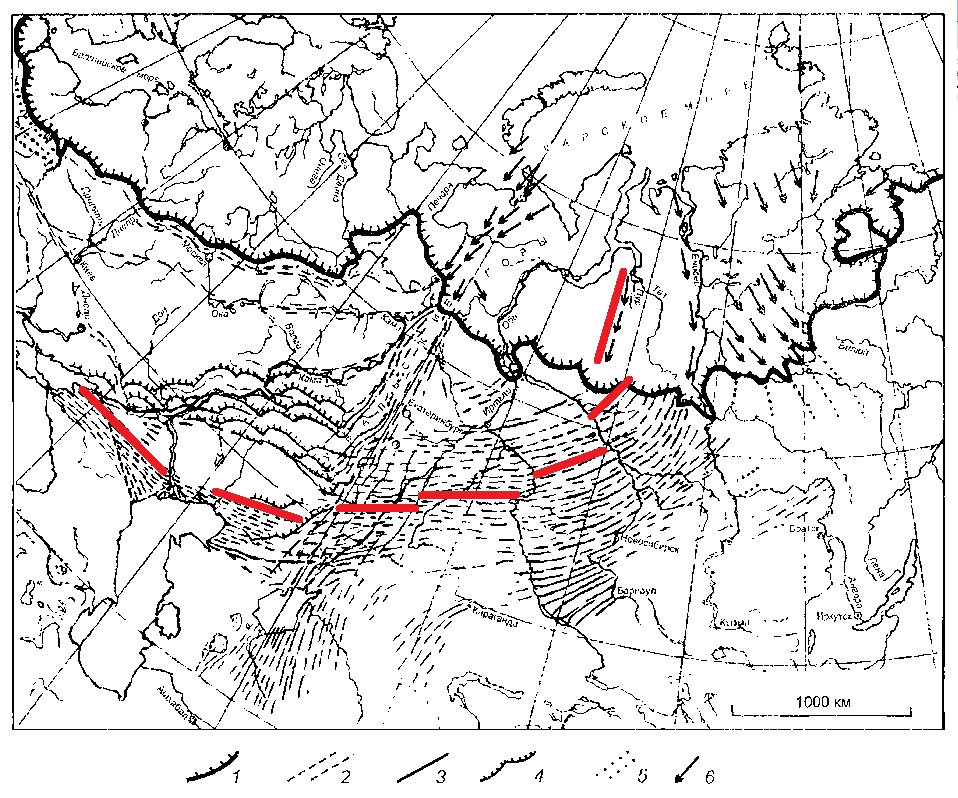
The most western ridge complexes are at the Taman’ Peninsula, and the most western alluvial soil of the ocherous colour are found even in Romania and Bulgaria.
At the Taimyr Peninsula and further to the east, the slope angle of the suspension traces is more than 90 °. These traces all together allow calculating characteristics of the suspension drift with sufficient accuracy.
14.9. VARIATIONS OF THE SUSPENSION MOVEMENT
The density of the eastern and western parts of the meteoric shower changed a randomly, that is, there were accidental and repeated strikes on the weakened ground from different directions that created illusion of several glaciation types different in their characteristics. Breaks of the meteoric shower and change of its any characteristics seem also natural - from the size of the bodies to the size of the average charge - that definitely left traces on the Earth surface. Layers were formed in a random way, and there are scientific conclusions about extremely fast formation and disappearance of glaciers.
14.10. GENERAL CHARACTER OF THE SUSPENSION
The ridge complexes are laid with ignoring of natural obstacles in the location, and boulders are brought uphill that makes difficulties for any explanation. In practice, neither the glaciation hypothesis, nor the flood hypothesis will not separately give the exact description of the occurring: the suspension acts as both an ice shield, a water and mud flow and as a snow and sandy storm.
The way that permafrost cells were formed better indicates its initial consistence: liquid and inclined to layering.
Fig. 45. Permafrost cells and the dried-up earth

14.11. SPEED OF THE GLACIATION
Soil and lakes frost penetration goes quickly, less, than in half a year, as it is proved by isotopes and perished biota research.
14.12. NOT CARBONIZED BIOTA
Some part of wood and pleistocene fauna is buried without any signs of carbonization that can be explained by heterogeneity and nonsynchrony of processes happening in the region.
14.13. GLACIATION IN TROPICS
There are no obstacles for repeating some parts of this scheme in the tropical regions as well, but in smaller scale. It explains "glaciation" without change of the climatic zone and destruction of all tropical flora and fauna entirely.
14.14. THE ANNALISTIC EVIDENCE
There should not be alive eyewitnesses of the incident; however, something was described really precisely from some distance: sharp cooling, pressure decrease, electrical discharges, a shock wave, shock wave degeneration into the sound one, the Prandtl–Glauert singularity with explosive condensation of the atmospheric moisture in the form of downpour and in the cooling conditions in the form of hailstones.
217 Battle of Platcentia. The rain and wind whipped the Carthagenians directly in the face and with such force that they... fell down to the ground... the wind grasps their breath and presses the breast. Suddenly over their heads something moaned and begun to roar, there were terrifying peals of thunder, lightnings began to sparkle... the downpour burst, and the wind blew even more severe. Clouds... began to strew hailstones... the hailstones were followed by such great frost that if anyone in that pity heap of people and animals wanted to rise and stand up, he could not do it for a long time. Throughout two days they stayed at that place, as though in a siege; many people perished, as well as a lot of pack animals, together with seven elephants.
15. FORMATION OF THE SAHARA LANDSCAPE
There are also analogues of ribbon lakes and especially ridge and hollow complexes in Sahara; the Google-maps allow seeing them, and the offered theory - to explain the sequence of their formation in details. To begin with, let’s examine the vicinities of Emi Koussi Volcano of in the Republic of Chad; the first fact that is evident is the ridge and hollow complexes which curve the volcano around.
Fig. 46. Emi Koussi Volcano

Let's consider these complexes in details. Smooth curving is obvious; the same curving, and, in the same order - from the north on the southwest, and then to the west, is also typical for ridge and hollow complexes of Russia.
Fig. 47. Ridge and hollow complexes in vicinities of Emi Koussi Volcano

Let's consider the picture closer. Rock masses act as ridges, and these masses have “shades” from the south-west. The factor that caused the erosion of rocks moved from the northeast, therefore the parts of the rock masses sheltered under high picks, are better preserved from the “leeward” side.
Fig. 48. Erosive "shades"

There is a question why these complexes are curved. The simplest assumption is as follows: the wind bearing abrasive sand, goes around obstacles. Something similar we see in the ring structure to the southeast to Emi Koussi Volcano: the ridges are smoothly curving near the ring.
Fig. 49. Smooth flow of the ring structure.

If to see from afar, we can see that the ridges are similarly curved round all rock masses; in the southeast part of the masses, Emi Koussi Volcano is located.
Fig. 50. Rock masses flow

The main obstacle for the theory of the wind source of the ridges formation is a map of the basic seasonal winds, among which there are no winds located along the latitude.
Fig. 51. Seasonal winds of Africa

In the real landscape of the Sahara, ridge and hollow complexes located approximately along the latitude are clearly seen, and they are only in the southern part of the desert. Such orientation does not satisfy to either trade winds, or local winds at the present position of the pole or in Greenland. The conclusion is as follows: the origin of the complexes is not connected with wind erosion.
Fig. 52. The direction ridge and hollow complexes of the Sahara

Regularly suggested tsunami hypothesis also seems not reasonable; tsunami has short-term duration, so it can’t wash through rocks, moreover, in rows with approximately identical step between them. In addition, water erosion needs significant amount of time to have results, but it is hardly possible to imagine any constant powerful water stream flowing through the Sahara with this orientation for a long-term period.
The origin of the identical step between ridges can be explained by the wave properties of the stream having invoked the erosion. Wave properties of streams create rhythmical locating of dunes, sand spits in the Azov Sea and freakish ice crust in the coastal areas of the Black Sea Coast.
The cause of rock masses pliability is that the erosion evidence coincided with the dramatic lava or mud release from the African volcanoes. The lava stream was cut "alive", so where the top congealed layer was removed, the lower soft layers raised much faster. Pay attention that ridge and hollow complexes of the Sahara are obviously located close to the volcanoes and the rock masses having in the Google-maps the same colour and structural characteristics, as the rock masses of apparently volcanic origin.
The answer to the question about the matter of the medium having created these complexes is mentioned in this text above: it mainly products of meteorites’ destruction which do not have the space velocity (up to 72 km/s) and depositing on the Earth with a drift against the direction of the planet rotation with its rotation speed at this this latitude. In a case with the Sahara (20 degrees latitude), it is about 1600 km an hour.
What is 1600 km an hour? In glass solid machining by sandblaster, 650 km an hour is enough, and hydroabrasive steel shearing demands nozzle velocity of 3600 km an hour. That is, the existing landscape of the Sahara at depositing of the meteoric fragments, and, primarily, meteoric sand with the speed of 1600 km an hour could be formed in some hours.
Well, according to the recent research in Abu Hureyra, Syria, the temperature of that sand and fragments medium was, at least, from 1720 ° C up to > 2200 ° C [60], possibilities of landscape formation at that "sand and plasma storm" were almost boundless from our point of view.
Here is last question: why the stream curved around the rock masses of the volcanic origin. There is only one possible answer: the magma touched with the meteoric electric discharge changed its characteristics, including pressure, and the volcanoes severely erupted. The region of volcano eruption created its own upward pressure of gases, deflecting the passing over sand and fragments stream. An additional hypothesis: recently thrown out magma still moved along the slopes to the sides, removing already cut ridges.
In spite of all similarity of parametres of ridge and hollow complexes of Russia and the Sahara and the fact that they were formed in a half-day period, the medium, of their creation is different: in Russia it was ice, gas and soil cloud, and in the Sahara - sand and fragments meteoritic stuff.
THE END OF THE METEORIC INCIDENT
16.1. THE PROLONGED ATMOSPHERIC PRECIPITATION
The Prandtl–Glauert singularity accompanies high-speed leaving of the rarefied atmosphere zone and condenses the thrown out upwards and superfluous for atmosphere moisture.
396 BC It snowed in Rome for 40 days.
831 It rained for 40 days
1432 It snowed in Livonia for 40 days
1454 It snowed for 40 days to the south from the River Yangtze
1636 It rained in Spain for 40 days
1161 It snowed on the Day of St. Cross or 25 quarters (4.5 metres); and in India for 44 quarters (7.92 metres). Thereof all fish, birds and animal species died.
16.2. LEAVING OF THE RAREFIED ATMOSPHERE ZONE
As air fills the rarefied atmosphere zone (vacuum in some places) with huge speed, it is accompanied not only by the release of the overcooled moisture into the atmosphere, but also by shock effect (the target ballistic wave). Just in such situation at Northern Black Sea Coast, wild and domestic animals could be smashed in one heap and collectively frozen in the ice of 9-metre thickness.
A. M. 6255, 755 AD. The northern part of the sea for hundred miles from the coast turned into stone for thirty cubits (13,89 metres) in depth … When snow fell on such thick ice, its thickness increased for twenty cubits (9.26 metres), and the sea looked like land … In February … , by the God’s will, this ice split into pieces like high mountains which were carried by a great wind to Daphnusia and Hieron, and plenty of them gathered at the city up to the Propontis and to Abydos Island, filled up all sea; that we witnessed ourselves, thirty companions climbed up the ice floe and played there. There were both wild animals and livestock, which were already dead.
A. M. 6255, 755 AD. The same year in March, lots of stars were seen falling from heavens in great variety, and everyone looking at their this falling assumed it was the end of times; thus the heat was so great there that springs even dried up
The ice previously increased for 13.89 metres we will consider further on; the fact that is interesting here is that the potential original cause - the meteoric shower - is mentioned. As year began in March, meteors passed in the first month of the year, and February when the ice had already been carried to Constantinople was the last month of the same year. It is possible to explain the drying up of springs by the started processes of electrolysis in the underground water layers.
16.3. FORMING OF STONE FOAM
The output ballistic wave produces dramatic release of the overcooled dust, moisture and sublimation products upwards - after the leaving front of waves. There appears Prandtl–Glauert singularity with explosive condensation of the atmospheric moisture around dust particles and sublimation products; that would cause chemically and physically active mud downpour. Just at this stage, identical landscapes with the hardened foam are formed in Nevada and the Mangyshlak Plato. It would make sense to check up the conditions when the substances, which have stuck to the internal surface of cells, are sublimated.
Fig. 53. The identical landscape in Nevada and the Mangyshlak Plato [94; 95]

It is necessary to consider this circumstance as some kind of coincidence, but concerning the present pole Nevada and the Mangyshlak are located symmetrically in the opposite sides, approximately on one latitude and on the opposite longitude. Ribbon lakes in Siberia and in the USA to the north of the Great Lakes are symmetrically located as well, though in the USA they are smaller.
In the following annalistic evidence, there is interesting synchronous mention of mud, left trains and 40-day downpour, and it should be so: dust particles in atmosphere promote moisture condensation.
In 728 the Moslem army battled during 30 or even 40 days in mud and under pouring rain, that is why the campaign received the name of “dirty campaign”. As a result, the Arabs overpowered the Khazars on September 17th 728. When the Arabs came back home, they got into the Hazars’ ambush so they simply ran away, having thrown their trains.
CONSEQUENCES OF METEORIC INCIDENT
17.1. MORAINE GLACIER LAKES
In strict accordance with science conclusions moraine glacier lakes are formed, but the reason is not a glacier (around the Kara Sea, the thickness is 2.7 km), but the smoothed relief covered with chilled alluvial deposits.
Fig. 54. Last glaciation of the USSR territory [96]

1 - glacial covers of plains and mountains; 2 - floating ice shelf; 3 - lakes; 4 - channels of thawed snow drain; 5 - directions of their drain; 6 - drained shelves; 7 - ocean free from glaciers. Numbers near the lakes are their levels
Concerning the present geographical pole the moraine glacier Mansi basin is symmetrized to moraine glacier Lake Agassiz in the western hemisphere.
Fig. 55. Moraine glacier Lake Agassiz

In case of shift of the Earth rotation axis, faults would appear to renew the drain into the oceans in both hemispheres. Moreover, the crust over hydrocarbon deposits would sink, Beringia would go down, and there would be formed the relief familiar to us according to physical maps of the Arctic.
Channels of the main Siberian rivers are focused on the present pole, - as well as the second group of lineaments; that indicates the late period of the moraine glacier lakes drain into the Arctic seas.
17.2. FORMING OF LAKE CONCRETIONS
From west of the Caspian Sea and in Great Basin in the USA similar "moraine glacier" are formed reservoirs with a large amount of fine-dispersed alluvial masses at the bottom. In this identical semifluid environment spherical concretions are synchronously formed.
Fig. 56. Concretions in New Mexico and Mangyshlak

17.3. DEPOSITS AS CONDITION OF LANDSCAPE FORMATION
Later, after shift of the Earth rotation axis when the inclination of the geoid would change, waters would slide, having pulled down the largest part of still semifluid deposits, and generate at the planet symmetric latitudes and longitudes identical landscape.
Fig. 57. Landscape of Ustyrt Plateau and Nevada

At that direction of the axis displacement that follows from the map of soil zones by V. Dokuchayev, semifluid masses of Ustyrt Plateau would slide to the Caspian Sea and masses from Great Basin in the USA, probably, - to the Gulf of California.
17.4. DECREASE OF INSOLATION
The dust thrown out into the stratosphere reduces insolation for a long time, and it is not the smoke from fires which annalists usual mark.
44 the Sun was eclipsed all year long, and the air was cold and foggy
137 the Sun gave faded light like the Moon without beams all year long
526 the Sun flickered without beams like the Moon all year long
536 in Mesopotamia the Sun was eclipsed for18 months
562 the Sun was eclipsed for 8 months.
564 during 18 months the Sun shone only for three hours per day
624 the Sun darkened in the month of Arek (March – April) until the month of Kagot (December – January)
934 the Sun lost its usual shine for several months
1371 for almost two months there was such great impenetrable haze that it was impossible to see the person face in two sazhens
1384 it was haze and obscuring which proceeded for many days. Birds could not fly
1601 All year, as well as the next year because of high-altitude smoke the sun and the moon were constantly reddish, pale and without shine
17.5. DUST DEPOSITS
Some part of the fine dust thrown out into the atmosphere would go round the planet several times, some part would be attracted to the polar regions. Probably, therefore, the polar soils are comparable to the Ukrainian ones according to the humus amount. Deposits of this type lie at heights in uniform thickness layers, without any signs of water activity, than bring researchers into confusion. Probably, loessial deposits containing small fragments of bones of rodents and mammoths and up to 50-60 % of air bubbles are also consequence of this process.
Fig. 58. Loessial deposits

17.6. LOW-TEMPERATURE ISOTOPES
As naturally there are isotopes in the suspension indicating abnormal low temperatures, research of the isotope composition proves this factor that leads scientists to the conclusion of lower average temperatures of winter months.
17.7. "WARMING" AND DESTRUCTION OF FAUNA
As after the end of the meteoric incident resembling the Ice Age no life signs remain on the surface, the expected conclusion is made about pleistocene fauna destruction in close connection with the warming period.
17.8. FORMING OF ALLUVIAL ISLANDS
After the incident end there appear alluvial quickly thawing islands in flood-lands of the largest rivers in Siberia and jams from bituminized woods on New Land.
17.9. BOWEL OXIDES RESTORATION
The ionized hydrogen becomes “proton gas” with the highest penetrating capability. In bowels, there goes endothermic reaction of oxides restoration with hydrogen [97]. Ore occurrence are formed and rocks freeze through.
17.10. OIL SYNTHESIS
As a result of the electric discharge in the natural gas deposits, hydrogen as the most mobile element, tears off, and fragments of molecules form compounds with much less content of hydrogen than in natural gas, that is, oil. In the scientific world, connection of underground thunderstorms and oil formation is already being discussed [98]. Reaction is endothermic.
17.11. DECOMPOSITION OF METHANE HYDRATES
Methane hydrates in the bowels decay under the influence of the electric discharge.
17.12. EARTH CRUST SLUMP
Oil density is more than twice exceed the density of liquid natural gas, that is, oil synthesis should be accompanied by reduction of the hydrocarbon layer in volume and crust slump. As a result, the coastal part of the crust sank and became a shelf that adds nuances to the process of the seas transgression. The thickness of oil layers in rocks is estimated as 1100-1200 metres in some places that easily explains coast flooding in the epoch of Doggerland and Beringia on 8-135 metres. The closer to the electric discharge zone (The Arctic) it is, the greater the flooding is. In the process of decomposition of methane hydrates in the bowels methane hydrates layers would lose in volume for about 11 %. Present layers of gas hydrates have thickness of 400-800 metres; that is crust slump in case of such scenario would be noticeable.
In case of reducing of hydrocarbons volume in bowels, cavities would start to be formed, focal pressure drop would appear, and disintegration of gas hydrates in the bowels would be a chain reaction. Pressure drop would cause still greater chilling of rocks.
17.13. PERMAFROST ORIGIN
As the Earth carries out the cathode function losing heat in electronic emission [99], almost all processes described above are endothermic, characterized by heat removal that promotes fast, geologically speaking, permafrost forming, including the deep one. This effect brings its contribution to the superfast freezing of mammoths.
17.14. TWO LAYERS OF THE FROZEN SUBSOIL
Layers of the present and ancient permafrost can lie together, and separately: the bottom of the top layer is 50-100 metres down, and the roof of the top one is 80-200 metres down [100] that can be result of two different passes of the same meteoric shower over the Arctic.
17.15. DEUTERIUM SYNTHESIS AND MUTATIONS
Because of deuterium synthesis, insignificant mutations would start; the most part of mutations is connected with the next stage of the catastrophic crash development.
17.16. PRECONDITIONS OF NEOLITHIC REVOLUTION
This stage of the catastrophic crash would stimulate some part of preconditions for neolithic revolution: forming great ore occurrence, scattering of gold and swamp iron just on the ground in some places, generation and easier accessibility oil fields and destruction of the most part of the pleistocene fauna thus irreversible having undermined the hunting grounds. The man would be simply forced to take fodder resources under the personal control: cattle and poultry only under supervision, and grain and turnip for cattle only on the home field.
The Zaporozhye archeologists found shelters for the pets in the place of ancient settlement which appeared 8200 years ago [101]. This date is extremely adequate to the events of the epoch and obviously indicates the very first shelters in the history of our civilization.
THE RESUME
These points answer the same block of questions, as the glaciation theory. The data of field researches remains steadfast; the command theory is only changed. The resolved questions are solved, assumptions like glacier with the height from 2.7 to 4.0 km are not required, and, the main thing, clear dynamics of events is visible.
TECTOGENESIS. THE COURSE OF EVENTS
18.1. ELECTRIC DISCHARGE INFLUENCE ON MAGMA MOVEMENT
It is necessary to expect double influence of the electric discharge on magma: short-term change of magma circulation under the influence of the electromagnetic field of the meteoric shower and activation of new geochemical processes owing to the magma loss of some electrons. In the long term, it leads to the whole series of events:
- to focal change of the magma density;
- to weight redistribution inside the geoid;
- to occurrence of a new main axis with the least moment of inertia;
- to planet overturn according to Dzhanibekov;
- to displacement of the Earth rotation axis in new position;
- to change of the atmospheric flow;
- to change of the oceanic currents;
- transgressions and regresses of the seas because of the axis displacement and change of currents;
- to displacement of zones of trade winds and monsoons;
- to change of climatic zones;
- to change of rotational pressure;
- to occurrence of system of faults and shifts;
- to prolonged planetary earthquakes;
- to simultaneous volcanic eruptions worldwide;
- to emission of telluric and volcanic gases.
Let's estimate historical evidences, but remember that all of them are either repetitions of the complete scheme with the decreasing intensity having started about 8200 years ago, or just very good examples which can help us to understand something.
18.2. EVIDENCES OF THE EARTH OVERTURN IN LEGENDS
1. Eskimos of Greenland told missionaries that once the earth had turned over.
2. Pomponius Mela referring to ancient Egyptian manuscript sources said that from the beginning of their civilization development, the stars changed the course four times, and the Sun rose in the west twice.
3. In Egypt, during 11340… the sun rose not its usual place four times: it rose there where it now sets twice, and it set twice there where it rises nowadays. Moreover, it didn’t cause in Egypt any change of soil and plants fertility, the river flow, illnesses or human death rate.
4. The archeologist Harris found a papyrus in which it was mentioned that the south and the north had exchanged in places in the past.
5. In Syria (Ugarit), the text was found saying that goddess Anat changed the movement of stars and luminaries.
6. The Mexican codes contain the description of four directions of the Sun movement. Besides, codes tell about “four prehistoric Suns” and changeable parts of the world. The phenomenon of the Earth overturn in codes is referred to as "leaving of four hundred southern stars".
the Almighty has created the Repentance Gate in the west, which width of 70 years. They will not be closed until the sun ascends from that Gate side”.
The NOTE: in three legends the Sun rose in the west twice, (and came back to its usual position twice) that satisfies two basic directions of lineaments. It is very important that in Egypt the overturn in itself did not become the reason of catastrophic crashes.
18.3. THE OTHER SOUTH IN PICTURES
At least, three masters, - Vazi, Piranezi and the unknown author who has represented St. Peter cathedral building, - systemically show the south in the opposite side. It is neither a mirror effect and nor an error, it is made deliberately.
Fig. 59. Giovanni Battista Piranezi, 1773-1778 the south is in the opposite side.

Fig. 60. Giovanni Battista Piranezi, 1748. The south is in the opposite side.

Fig. 61. Juseppe Vazi, 1774. The south is in the opposite side.

Fig. 62. Juseppe Vazi, 1753. The south is in the opposite side.

The place occupied nowadays with the main altar, is always in shade, but in Piranezi’s representation, it’s all on the contrary, and the Catholic Church did not objected it.
Fig. 63. Giovanni Batista Piranezi 1768. The south is in the opposite side.

Fig. 64. Giovanni Batista Piranezi 1730. The south is in the opposite side.

Fig. 65. Building of St. Peter’s Cathedral. The sun is in the northeast.

The NOTE: Pictures reflect not constant position of the Sun, but a short-term phenomenon. Even if mother Earth turned over, the Sun would continue to shine from the equator, but during the period of overturn, the Sun could temporarily appear over the changing position northern pole. Pay attention, no natural catastrophic crashes during that moment occurred. Catastrophic crashes would come later when after the overturn the oceanic currents should change their flow, taking into account the displaced axis of the planet rotation.
18.4. THE STOPPED SUN
It doesn’t matter much whether there was the Earth overturn or not, but anyway the displacement of the Earth rotation axis should be accompanied by either seeming suspension of the Sun or seeming acceleration of its movement. During the planet overturn the daytime changing should also stop. Evidences on this phenomenon are both in legends and in annals, - including well-dated ones.
IN LEGENDS
In one of legends of the Aztecs, it is told that once the Sun and the Moon in the sky stopped, and the Earth plunged into darkness.
In China at the time of Emperor Jao the sun stayed in the sky during 10 days. 10 days the sun shone in India, 9 - in Iran. And in Egypt the "solstice" was changed by the same 7-day long night.
The Indians of Peru have a legend about night which lasted five days then the ocean overflowed and flooded the earth.
In legends of the Mansi, the Flood was accompanied by seven-day disappearance of the Sun.
IN ANNALS
There are four dated annalistic evidences on the stopped Sun.
1123 Prelate Feoktist, the Bishop of Chernigov, witnessed the miracles, which happened during the demise of pious Prince David Svyatoslavich and his burial. The prelate wanted to postpone the burial for the next day, but the sun stopped in the sky and did not set until the prince was buried.
1391 During the reign of one of Inca tsars, the dawn did not start for 20 hours. Calculations have shown that this event should have occurred in 1391.
1547, on April, 24th the miracle of the son of Nun ostensibly repeated again during the reign of Charles V during the Battle of Malberg).
1683 The sun shone three longer.
18.5. FAILURE OF SEASONS OF THE YEAR CHANGING
Overturn of the Earth according to Dzhanibekov leads to failure of seasons of the year changing: winter or summer comes for the second time. The evidences mentioned here are indirect as any curious things cod happen with weather, but it is better to keep an eye on them.
1289 in Riga there was winter … without winter. Flowers grew in fields, girl decorated themselves with violets for Christmas.
1303 Similar winter. Moreover, not only in Latvia. One of Old Russian annals says: “It was hot winter, without snow”.
1471 In February, buds blossomed out on trees.
1471 Autumn - in Europe fruit-trees blossomed again.
1473 October - in Russian lands trees blossomed again.
1493 In January in Livonia gardens blossomed, birds wove nests.
1521 January - in Germany sweet cherries blossomed.
1522 Autumn - in Europe trees blossomed for the second time, people gathered the second harvest of wood berries.
1530 January - in Europe wild flowers blossomed.
1539 Winter - in Europe violets blossomed.
1540 January - cherries blossomed in Tyrol, Austria.
1540 Winter - Warm winter in Western Europe, roses blossomed for the second time.
1586 Winter – it was warm in Western Europe. Trees blossomed again.
1592 Autumn - in West Russian lands tree leaves did not fell down, and trees stayed green, as they were in the spring.
1617 In January cherries … blossomed in gardens near Riga
1617 January - cherries blossomed in Baltic.
1816 Year without summer
1819 November - in Western Europe trees blossomed again.
1822 September - in Western Europe apple-trees blossomed again.
1822 In the Tambov province verdure appeared in fields on Christmas holiday, people picked fresh nettle for the Russian cabbage soup.
1822 In early November in Hamburg people ate fresh wild strawberry and raspberry.
1823 In January in Riga it was 30 C below zero, and in February there was first thunder-storm.
18.6. CALENDAR FAILURE
New year in antiquity and the Middle Ages was the time of debt and tax repayments - right after the harvest when the granaries were full. Therefore, transfer of the beginning of the year for half a year forward from March to September means failure of season changing. Here are dates of reforms with transfer of the beginning of the year from March to September.
31 BC East provinces of the Roman Empire
284 the Coptic (Alexandria) Calendar
312 The Byzantine Empire
462 The Byzantine Empire
537 The Byzantine Empire
988 The Byzantine Empire
1342 Russia (without specification)
1348 Muscovy
1425 Muscovy
1492 Muscovy
18.7. FAILURE OF CHURCH TRADITION
1479 During consecration of the Dormition Cathedral in the Moscow Kremlin on August, 12th the Rostov Archbishop Vassian and Chudovsky Archimandrite Gennadius declared that metropolitan Gerontius had broken the church traditoion having conducted the religious procession ‘not according to the sun rise”, that is not not from east to west.
The NOTE: such conflicts must have appeared in Churches after overturn of the Earth according to Dzhanibekov, and these conflicts are well documented.
18.8.1. MAGNETIC FIELD DIGRESSIONS
Officially, there have been two digressions of the magnetic field of the Earth in the recent 50 thousand years: the Laschamp event (41400 years ago) and Lake Mono event (34 thousand years ago). Complete magnetic inversions happened even less often. However, this question is too “hot” for today, just because even the scientific world acknowledges striated magnetic anomalies at the bed of the oceans, with interval of 40 km, as indication of extremely regular magnetic inversions [102].
Some years ago, the evidence of paleomagnetologists appeared in the press concerning the digression, which had left traces on Etruscanian ceramics, but today the discussion of this fact is only suitable for tabloids. The science prefers to be careful in judgments.
18.8.2. DISPLACEMENT OF MAGNETIC POLES
I will quote here: Researchers from Great Britain and Denmark have analyzed the satellite geophysical data for 20 years and have found out that the displacement of the northern magnetic pole of the Earth is determined by some "competition" of two magnetic anomalies one of which is near northern Canada, and the other - under the Siberian shelf. Earlier geologists of NASA found out that the displacement of the Earth axis could be connected both with the Ice Age end, and with movement of mantle flows... [103].
That is what occurs in our model.
18.9. EVIDENCES IN LANGUAGE
The direct evidence of change of the world parts has remained in the Persian language.
خاور [khavär]
1) east; the East;
2) bookis: sun;
3) obsolete: west; the West;
خاوران [khaväran] obsolete
1) the East;
2) east and west;
باختر [bahtär]
1) west;
2) obsolete: east;
3) historical: Bactria
The complete text and references in note № 46.
18.10. TWO EASTS AND TWO WESTS
In the Koran the expression «two easts and two wests” is regularly mentioned, thus there are no problems with the north and the south. Such situation should happen in case of the Earth overturn according to Dzhanibekov. Citations and references are in note № 47.
18.11. THE LIST OF EVIDENCES OF THE EARTH OVERTURN
1. Legends about change of parts of the world
2. Legends about the stopped Sun
3. Annalistic evidences of the stopped Sun
4. Images of the different Sun position
5. Opinion of geologists of the XIX century
6. Failure of seasons changing (two summers or two winters in succession)
7. Calendar failure for half a year
8. Failure in the church tradition
9. Hypothetical digression of the magnetic field in Etruria
10. Evidences in language
11. Two wests and two easts in the Koran
19.1. ROTATION AXIS SHIFT
The evidence of the rotation axis shift could be calendar failure for less than half a year. Such failure happened in 46 BC, (annus confusionis – “year of confusion”) when the Romans added to a calendar year, except Mercedonium … two more intercalary months - one for 33 days, and another one - for 34 [104]. Such situation should become a unique one; however its analogue is also noted in 1793 in France [105]. The major political events repeated on the average, every 2 months and 5-6 days as though they were fixed in two different calendar systems. These 2 months and 5-6 make the same sum of 33 and 34 days, as the ancient Romans had. By the way, in France in 1792, the ships had ancient Roman names. No name resembling “St. Nikolay”, so to say - only Gorgons, Achilleses, etc.
ONE MORE COINCIDENCE
After the shift of the Earth rotation axis, the season should change too, and it is possible to estimate roughly, how much. The inclination of the Earth axis is 23.5 °. That is, the difference between the winter and summer position - 47 °. If the geographical pole shifted for 17 – 17.5 °, it would be … 17-17.5: 47 * 100 % = 36.2-37.2 % of a half-year or 66-68 days – it is already twice noted sum of 33 and 34 intercalary days.
It is clear that it would hardly become the proof: calendar failures are much easier to explain by count failures, than failures of stars run, but there are also two direct scientific evidences. The first of them is queried.
1783 The British Isles suffered from heat, thunderstorms, plague, wasps and ubiquitous dry fog. Some scientists suspected that the axis of the Earth shifted. Inhabitants of Castlton in Derbyshire lived in the shade of the nearby mountain the most part of winter. They asserted that the first sun of the year appeared in their houses after the winter solstice some days earlier, than it was 50 years ago, and that the shade of their mountain was shorter for some yards that time than should be in the middle of winter.
And here is the second evidence has sound scientific base.
CITATION: observations of Le Mone made in 1743 with the help of gnomon in the Church Of Saint-Sulpice in Paris showed reduction of ecliptic inclination in comparison with the measurements made Giovanni Cassini in Bologna in 1656.
19.2. THE LATITUDE FAILURE IN 1831-1832 FOR 2-4 °. DOCUMENTS
Daily data of risings and sets of the Sun and the Moon for St.-Petersburg and Moscow, in the rage from March 1st to March 31st (according to Julian calendar) are taken. From 1831 to 1832 “the month increase” of rising in St.-Petersburg increased for approximately 10 minutes, and in Moscow - for 9 minutes. Till 1831 the Sun "increased" in spring more slowly, and it means that geographically cities situated 2-4 degrees southwards [106].
St.-Petersburg (modern latitude 59°57 '), for 31 day (30 twenty-four hour days) the Sun rises earlier for:
90 mines (1833) the Source: http://elib.shpl.ru/
91 mines (1832) the Source: http://elib.shpl.ru/
81 mines (1831) the Source: http://elib.shpl.ru/
81 mines (1829) the Source: http://elib.shpl.ru/
Moscow (modern latitude 55°45 '), for 31 day (30 twenty-four hour days) the Sun rises earlier for:
77 mines (1833) the Source: http://elib.shpl.ru/
78 mines (1832) the Source: http://elib.shpl.ru/
69 mines (1831) the Source: http://elib.shpl.ru/
68 mines (1829) the Source: http://elib.shpl.ru/
19.3. OTHER LATITUDES ON THE MAP OF 1813
The map of theatre of war of the Russian Empire against France and its allies. Edited by titulized adviser A. Savinkov, 1813 [107].
Zhitomir, old latitude 48 ° 25'
Zhitomir, modern latitude 50°15′53 ″ North
Jaşi, old latitude 45°50'
Jaşi, modern latitude 47°10′00 ″ North
Pskov, old latitude 54 °
Pskov, modern latitude 57°48′48 ″ North
Riga, old latitude 53°35'
Riga, modern latitude 56°56′45 ″ North
19.4. OTHER DIRECTION TO THE POLE
On maps of Crimea for 1750, 1782 and 1787 [108] geographical graticule has other orientation to the pole, with declination for 17 ° to the West.
Fig. 66. Comparison of geographical graticules on a modern map (1922) and on maps of 1750, 1782 and 1787

Now let’s have a look at the originals.
Fig. 67. A map of 1750

On the map of 1782 we can see the process of merging of maps of different origin: in the northern part the graticule is modern, and the latirude of Ochakov is in the intermediate location.
Fig. 68. A map of 1782

Fig. 69. A map of 1787

The same declination has the direction to the north on the plan of the Tsaritsynskaya watch line of 1724.
Fig. 70. Plans of the Tsaritsynsky watch line of 1902 and 1724

At least tens of cities’ plans 1770-1824 from full collection of laws of the Russian Empire have the same declination and the same situation is with old plans of European cities. Orientation of plans and, especially, geographical graticules of the big maps to the magnetic pole in cartography is not practiced, that is, we see not magnetic, but geographical pole shift. Further on, here is a couple of maps as an example.
Fig. 71. Plans of Nizhny Novgorod of 1824 and 1896

The latest found plan with similar orientation to the north is the plan of the fort Golovinsky (nowadays Golovinka, Sochi), founded in 1839.
Fig. 72. The plan of the fort Golovinsky

19.5. ABOUT DATING OF THE EVIDENCE OF THE GEOGRAPHICAL POLE SHIFT
Resolute statements would be premature, however it would be necessary to point out certain facts.
MAMMOTH FAT
Dynamics of discoveries of mammoths with flesh is eloquent enough: the number of expeditions grows, and the frequency of discoveries falls. It indicates the speed of decomposing process of the remains and rather recent period of the burial. It is very important that in 1901 O. Gerts and E. Pfizenmayer, zoologists from the Russian Academy of Sciences, fixed presence of thick fat layers in the meat of the mammoth from the Berezovsky burial.
CITATIONS:
Well conserved on the humerus and femur, as well as on the pelvis, meat was threaded with thick futty beds fat layers … Abundant fat on the corpse had white and grey colour … Deeper fat layers amazed us with its sponginess structure [109].
Now no fat in the corpses of mammoths are found.
CITATION: … for thousand years there was natural leaching of fats in the permafrost ground, there is only tissue protein left [110].
Rates of leaching indicate that it began, more likely, at the end of XVIII century, not 8-9 thousand years ago as the radiocarbon method shows it.
THE WHOLE CORPUSES IN THE PAMPAS LOAM
In a fragment of 12 chapter “The Problem in the South America and West Indi” from the book of sir Henry H. Howorth «The mammoth and flood. Attempt to opposite to the theory of constance with the facts of modern geology» (p. 345-354) [111] it is pointed out three times that during Charles Darvin's expedition they found not only bones, but also the whole corpuses of huge fossil mammals in the pampas loam of the South America.
CITATION:
… the person would hardly take up the burden to kill these large beasts demanding great efforts for savages, and doing it just beause of simple recklessness. He would not abandon the corpus safe…
I assert that this destruction was invoked by the continent flooding; the opinion which is completely based on the facts presented concerning large deposits of pampas which were obviously formed by water. How else can we explain this final fracture and uniformity of depositions containing bones in the pampas? I find the obvious proof of it in a large quantity of bones and the whole animals, which are mostly found at the valleys exits as Mr. Darwin poits out.
Bones, besides, are found only in low layers while the whole animals are disovered along the perimetre or top of the basin. Thus, they are very rare in Buenos Aires, but numerous in the East Strip and White Gulf.
20. CHANGE OF THE COURSE OF ATMOSPHERIC CURRENTS
1692 Jamaica. After an earthquake there are usually no winds from the land and instead of them night sea winds often blow: the phenomenon, extremely rare before, and ordinary now
21.1. TRANSGRESSIONS AND REGRESSIONS OF THE SEAS
First of all, it makes sense to quote the base thesis from the initiative project of the Russian Federal Property Fund 02-05-64428. “Existing hypotheses and models do not offer any satisfactory explanation of the reasons of catastrophic transgressions of inner seas of Eurasia” [112].
Transgressions and regressions of the seas can have many reasons:
1. Displacement of the axis of rotation
2. Overflow from the next basin (Caspian Sea-Manych River-Azov Sea)
3. Change of the course of currents
3. Change of electromagnetic characteristics of the basin (Jusup Hizirov’s effect)
4. Screw warpage of the basin bed or adjoining plates
5. Slumps or raisings of plates following the results of displacement of the rotation axis
It is clear that annalists do not know the reasons of transgressions and regressions, though they reflect the situation in details.
365 Sokrates Scholastic: The seas have changed their habitual boundaries, in some places the land was shaking so greatly that there where people could walk they can only swim now. In other places the sea has moved so far back from the shore that the sea-bottom became dry”.
21.2. OVERFLOWS DURING DISPLACEMENT OF THE EARTH ROTATION AXIS
As a result of displacement of the Earth rotation axis waters approach:
- In the sector from the Kamchatka Peninsula to the Caucasus - to the south and to the West;
- In the sector from the Kamchatka Peninsula to California - to the south and to the east;
- In the sector from the Atlantic Ocean to the Caucasus - to the north and to the east;
- In the sector from the centre of the Atlantic Ocean to the North America - to the north and to the West;
- In Australia - to the south and to the West;
- In the South America - to the north and to the West;
- In Southern Africa - to the north and to the east;
- In the southeast part of the Pacific Ocean - to the south and to the east.
21.3. THE SUPERIMPORTANT CASPIAN SEAL
The Caspian seal prefers cold water and is biologically connected with ices where it propagates, brings up cubs and fades. These facts support the hypothesis about the oceanic origin of the seal. Thus, the conditions, which promote the seal appearance in the Caspian Sea, are strict: it is not the period of the meteoric incident having killed all living beings, and not the period of drain of moraine glacier lakes to the north on the faults. Most probably that the seal got here at the moment of displacement of the Earth rotation axis when some part of water of the Arctic Ocean flew into the Caspian Sea. The computer model showing the reality of such scenario is created [113].
Fig. 73. Oceanic water in the Caspian Sea [113]

21.4. THE FLOOD CAUSED BY THE AXIS DISPLACEMENT
It is known that the largest land areas - Doggerlend, Sundalend, Sahulend and Beringia - were flooded in pleistocene, approximately 8200 years ago; however, in the book “Sinking cities”, at least, 90 known cities “of antiquity, the Middle Ages and later periods” are mentioned, nowadays being under water, as a rule, at the depth of 8-12 metres, but in some places even deeper.
The reason of flooding is axis displacement, which happened, probably, not once. East basins for centrifugal forces appear at once above western ones - for hundreds metres. First of all, the water of the Arctic Ocean brings the seals to the Caspian Sea. Then the moraine glacier lakes round the Aral Sea flood cities of the western part of the Caspian Sea, in particular, Hazarian Semender. During this period "the Martian" landscape of Mangyshlak and Nevada is formed. Then water of the Caspian Sea floods the Azov and Black Seas the Kuma–Manych Depression. And, finally, the Black Sea water floods cities of the Mediterranean through the Bosporus Strait. For this reason the Black Sea sapropels are found on the Aegean Sea bed.
SCIENTIFIC CONFIRMATION OF THE DECLARED
Are executed палеогидрологические reconstruction of internal basins of Eurasia representing the Cascade of the Euroasian Basins from Arala through Uzboj to the Khvalynsk sea, further through Manych-Kerchensky passage to the New Evksinsky sea and through Bosporus to sea of Marmara up to Mediterranean sea. For these basins calculations of levels, the areas of water area and flooding, volumes of water masses, salinity, and also water exchange volumes between them are executed. [112].
THE LIST OF THE SUNK CITIES
Adriatic sea: Vibion, Matamautso, the Back, Epidavr Illirijsky.
Sea of Azov: Taganrog.
Caspian sea: Abeskun, Bandovjan, Kegnja-Bilgjah, Naryn-Calais, Terkis.
East Mediterranean: Helike, Corinth, Peraeus, Gifion, Faros, Atlit, Kesarija, Caesarea, Vurgunda, Tristomo, Lefkos, Vathipotamos, Salamin, Mariumpolis, Pathos, Kurias, Amatos, Mohlos, Chersonese, Panormus, Metallon, Amnisas, Moni Arvi, Elunda, Psira, Spinalonga, Itanos, Kapa Plaka, Zakros, Ampelos, Sidon, the Shooting gallery, Apollonia (Cyrenaica), Ptolemaida, Tauhira, Arvad, Ajfuza, Taps
The western Mediterranean: Iol, Vajja, Potstsuoli, Mizenum, Fos.
Black sea: Apollonia (Sozopol), Dionisopolis, Mesembrija, Odessos, Anakopija, Dioskurija-Sebastopolis, Gejunessa, Fanagorija, the Germonassa-god-forsaken hole, Tomy, Istria, Veljaus, Kalos, Limen, Nimfej, Panticapaeum, Sugdeja, Feodosiya, Chersonese-Korsun, Kitej, Zefiry, the Acre, Olvija.
Aegean sea: Fairies, Lorenzon, Kardamil, Minna, Tigani, Pilus, Kalidon, Eritrea, Smyrna, Teos, Notium, Miletus, Bargilija, Andriasmira. [114]
21.5. LAST TRANSGRESSION IN THE REGION
In 1808 the sea level at Moesia (Romania) rose for 4 metres, and the importance of this fact is difficult to overestimate.
21.6. MASS GRAVE PLACES AT MANYCH
First, let’s have a look how the real Manych barrow - without Scythian gold – looks like.
THE EVIDENCE OF THE EYEWITNESS
When they dug irrigation channels, a lot of dug barrows were opened along the route. If it was a single burial place, all was typical. Clothes, utensils, weapon. In barrows where there were hundreds of skeletons, it was a different case. Only bones. Piled in a mess. Neither fabrics, nor iron.
Hundreds of barrows... Barrow grave "Kievka-1" is washed away now. Bones are covered by a metre ground layer from the bottom to the top. They tried to dig out a trench for duck hunting at the top of the grave, 70 centimetres below there were just bones. The barrow is 8 metres height. There is a regiment buried there. I think if to fix co-ordinates of barrows on the map, they would show the coastal line of the Manych flood [115].
NUMBER OF BARROWS
In the Order of the Ministry of Culture of the Stavropol Territory of 15 May 2006 N 56 115 barrow graves and 529 barrow earthfills (the complete list is in the Appendix № 44) are noted. In Kalmykia, 1289 barrows are investigated, and, according to estimates, there are thousands of them. E.D. Felitsyn, the Kuban army officer made the map of barrows of the Krasnodar Territory and he counted 6000 of them. At least, there are several hundreds barrows in the Rostov Region.
THE COMMENT
The flow along the Manych involved, first of all, the surface water of the Caspian Sea – those where the bloated carcasses floated. In such situation the coast of Manych passage should have a formed strip of deposits of the carcasses, similar to the seaweed thrown ashore.
It would be logical for the Romanovs to collect those deposits of remains in compact barrows with their subsequent cover with ground. Therefore, indeed, the arrangement of mass grave barrows should maych the Manych coast in the period of active overflow.
Clothes on bones were absent, and it means that collectors of bones collected just bones, and remainders of the clothes and personal things and should stay lying as a strip there where the carcasses were before. Such strip, if it is found, would be of enormous archaeological interest, as it would represent one-time picture of all cultures of the Caspian zone.
In Russian press of the middle of XIX century (1842-1849) there was a message about the ancient Roman ship found sticking out of the clay Manych coast in the magnificently ideal condition.
THE SERBIAN ANALOGUE OF THE MANYCH
Wikipedia. Moesia. When Prisk as a member of the Byzantine embassy went through Naiss in 448 (modern Serbian Nish), he found it “deserted and destroyed by enemies … along the river bank all was covered by the bones of people killed in battle”.
21.7. THE FLOOD CAUSED BY GROWTH OF OCEANIC RIDGES
As a whole, the land was flooded even there where the sea should recede. Doggerland sank for about 200 metres Beringia - for 135 metres, and Kamchatka, which was supposed to rise, as a result sank for 126 metres. The pleistocene continent which part is modern New Zealand sank almost entirely [116]. The reason: growth of mid-ocean ridges that reduced the reservoir of the basins.
The catastrophic stage of mid-ocean ridges’ growth is obvious consequence of geoid squeezing with opposite charged Polar Regions. Spreading (expansion of plates) did not cope with the new level of pressure from below, ridges rose, and the reservoir of the ocean basins became smaller.
The variant of mechanic compensation is also possible: ridges grow, and shelves sink - as on the balancer board swing.
Fig. 74. The Mid-Atlantic ridge

The coasts can be flooded unequally, for example, depending on activity and proximity of mid-oceanic ridges.
21.8. FORMATION OF FJORDS
Fjords, that is, the flooded mountain valleys are typical, first of all, for the polar regions. Good examples are: Norway and Antarctica.
Fig. 75. The relief of the Antarctica surface without a glacial cover [117]

Electric catastrophic crash in the Arctic definitely influenced the Antarctic - as the second electrode in the electrolyte solution. The result: squeezing of the geoid with opposite charged Polar Regions. However, there can be two more reasons that are important: displacement of the Earth rotation axis and growth of mid-oceanic ridges.
21.9. DETACHMENT OF ICE SHEETS
Judging by the depth of Doggerland flooding, Greenland sank for 200 metres. It means flooding, detachment and emerging of the ice layer pieces along all coast of Greenland. Iceland was blocked by pack ice with breaks since 1420 till 1822, and in English language pack ice means the ice detached off land glaciers. It means that 1420 can be one of dates of flooding of some part of Greenland.
21.10. COMPLEX FLOODING OF THE ATLANTIC
In Northern Atlantic, flooding of the land should certainly have complex character: both because of axis displacement and growth of ridges.
21.11. DATES OF IRRETRIEVABLE FLOODING OF SOME PART OF THE LAND
The Atlantic region, there is description for each date.
France 1696
Denmark 1362
Belgium 1375, 1477, 1530
Germany 1287, 1362, 1436, 1477, 1634, 1703
Britain 1287, 1347, 1348, 1356, 1362, 1385, 1607, 1665, 1688, 1703, 1755,
Holland 838, 1164, 1170, 1196, 1219, 1248, 1280, 1282, 1287, 1362, 1401, 1404, 1421, 1424, 1470, 1477, 1509, 1530, 1532, 1551, 1570, 1583, 1584, 1632, 1703
21.12. THE SUNK CITIES OF THE ATLANTIC
Let us consider specific settlements.
ENGLAND
In 1287 the city of Winchelsea and Broomhill were destroyed and moved higher
Since 1362, the city of Ravensrodd was completely under water, however, not slumps, but storm were guilty.
In 1607, around Bristol, 520 sq. km of land sank, but it was not considered too.
In 1665 in Southern England the city of Brighton sank, nowadays it is approximately 40 metres downwards.
The city of Danvich sank in nine steps in 1286, 1287, 1328, 1347, 1348, 1385, 1688, 1717, 1755.
HOLLAND
From 1248 to 1632 the cities of Groningen, Dort, Sliedrecht, Vaard, Scheveningen, Walcheren, Arnemuden, Reimerswaal, Saeftinghe, Oostmanskapelle sank. The rural provinces also sank synchronously, but the names of villages did not remain in the documents.
GERMANY
In 1362 the city of Rungholt on island Strand sank. The word combination “untergegangenes Bistum” means the “the sunk diocese”, however, the most part of dioceses of Germany which were registered as sunk ones, are located on the land nowadays. It means that either the sea receded, or the population together with the toponyms moved higher.
Das Bistum Merseburg ist ein untergegangenes Bistum.
Das Bistum Halberstadt ist ein untergegangenes Bistum mit Sitz in Halberstadt.
Das Bistum Havelberg ist ein untergegangenes Bistum mit Sitz in Havelberg im heutigen Landkreis Stendal.
Es geht zuruck auf ein untergegangenes Bistum der antiken Stadt Adramyttion im Nordwesten Kleinasiens
Das `Bistum Chiemsee` ist ein untergegangenes Bistum der Romisch-Katholischen Kirche.
Das `Bistum Bremen` ist ein untergegangenes Bistum der romisch-katholischen Kirche in Deutschland.
Ein Weihbischof wird immer auf ein untergegangenes Bistum geweiht (i.p.i. = in partibus infidelibus).
Fig. 76. The sunk dioceses

PORTUGAL
The old quay of Lisbon after the earthquake of 1755 lies deep under water. The city is located higher and, consequently, it is not considered as a sunk one.
WEST INDIES
1692 Port Royal
THE USA, FLORIDA
Exact date of the city of Sent-Ogastin flooding is not known. Presumably, it is 1669 (In 1668 the city of Terki on the Caspian Sea sank) when the order was issued about moving the fortress further away on the land.
21.13. COAST RAISINGS
Coast should rise, first of all, in the Far East and in the South America. The greatest raising occurred 8200 years ago, when complete skeletons of whales were found high at the coast Chiles (Atacama), Argentina and Alaska. But residual processes still went on at the historical period.
1822 The earthquake lifted all Chiles on November 19th, 1822
1822 In Valparaiso the ship broken at the coast appeared after the earthquake on the land
1822 The Coast of Lake Quintero joined with the sea, was lifted very high, above the water level
In Chile, Darwin became the witness of a great earthquake on February 20th, 1835, and saw the signs indicating that the land had just risen. This risen layer included shells of the bivalves, which appeared above the level of high tide.
The NOTE: in Chile the tide reaches 3-5 metres, that is, in 1835 the coast of Chile at that place rose for more than 5 metres.
21.14. SCREWING OF THE CRUST SITES
After displacement of the Earth rotation axis the masses of the geoid, including the crust, are displaced too to occupy the new, optimum position for the centrifugal forces. The displacement maximum to the north is in the Atlantic, at 40 ° West longitude, and the displacement maximum to the south is in the Far East, at 140 ° East longitude. The result: each solid site of the crust experiences the conflict of forces, and the site is screwed. In the Old World, the southeast and northwest corners of basins should be screwed downwards; in the New World – the southwest and northeast ones.
Fig. 77. Variants of the basins screwing

The Yoldia Sea was screwed like that. The same happened with the Caspian Sea, which experienced transgressions in 1668-1669 and 1728. Here are the citations:
On August 17, 1668, by the Named Order of His Majesty Honoured Tsar and Grand Duke Alexey Mikhajlovich, concerning Three-wall city near the Caspian Sea, the troops were resettled on the river Kapay, in the so-called Old City, because of the great flood [118].
On August 17, 1668, the western coast of the Caspian Sea, water and land began to tremble. It was a severe earthquake. However, the land level sank and water rose quickly, though smoothly. It was possible to safe not only the majority of townspeople, but also many valuable things, including archives of the local Tersky Cossacks. All the same — the city sank under water in for some days [119].
It is important that in the same 1668, on August 17th – Earthquake destroyed the city of Epidaurus in Greece, 8 thousand persons died [120].
“The distance from the mouth of Tumenka to the sea reduced - at first it was 30 versts, then - 5, and in 1669 it was necessary to move Terki because of “flooding” of cities with the sea water [121; 122].«... The Terki city in 1728 is removed... After that the place of the city of Terki previous location was flooded by the sea, and nowadays it is completely under water” [123].
Red arrows indicate the areas of Uzboi Vallis and Terek delta which are sunk nowadays and the lifted areas of the Kura and Mangyshlak mouth. Naturally, there are no settlements at the present Kura floodplain based before the middle of the XIX century. The fortified city of Terki, judging by the documents, should be found 30 versts from the coastal line at a depth of about 40 metres. That fact described as sea transgression or regression frequently means both these processes together.
Fig. 78. Outlines of the Caspian Sea in 1720 [124], before the bed screwing and modern ones.

The date of Terki city flooding (1668-1669) is not unique; in 1669 the city fortress St Augustine which had sunk at the in Florida was decided to be build up anew [125], - the ruins of the old fortress were found out during the great ebb in 1871 [126]; in 1670 there was the second evidence of the Amu Darya River flow deviation [127], and in 1665 the city of Brighton in Southern England sank for the same 40 metres [128].
During the same historical period some parts of Holland (1646, 1651, 1654, 1664) sank, the part of Greece (1650) and the USA (1649, 1657) and ‘the Swedish flood” was fixed in Poland (1655-1660) after which the country lost more than third of its population.
21.15. TRANSGRESSION OF THE CASPIAN SEA IN 1669-1669
The citation: “The distance from the mouth of Tumenka to the sea reduced - at first it was 30 versts, then - 5, and in 1669 it was necessary to move Terki because of “flooding” of cities with the sea water” [121; 122].
The stars on the map indicate both positions of the fortress of Terki, and its removal for 35 versts means that prior to the beginning of transgression of 1668-1669 the area painted by yellow colour was the land. There is also an evidence. Alexander Balatskiy: As a former inhabitant of Mangystau I confirm: local Kazakhs said that earlier they rode the camels from the fort of Shevchenko to Astrakhan.
Fig. 79. Transgression of the Caspian Sea in 1668-1669 (yellow colour)

SIMILAR ANNALISTIC EVIDENCES
1325 The Caspian Sea rises every year for one palm, and some good cities have already been destroyed, so eventually the Caspian Sea would join the sea of Tana
1344 The earthquakes in Ven-tcheou caused the overflow of the sea
1649 Shallowing of the Guadalquivir River did not allow sea vessels to be moored in Seville
1812 In Mississipi, the earth strip of around 500 versts of length and about 200 versts of width sank for eight foots below the initial level
1819 The earthquake on the border of India and Pakistan, faults of the land surface and lowering of tectonic blocks below the sea-level
1855 New Zealand, the coastal line rose for 2 metres
Complete verdict is complecated in each case, however, it is important that in the Iberian Peninsula, the harbor of Lisbon sank, and the harbor of Seville rose, as it should happen.
21.16. BORDERS OF CATHERINE’S II EXPEDITIONS
In 1769, the Academy of Sciences sent to the Aral and Caspian region five expeditions [129]:
- The Orenburg expedition of academician P. S. Pallas from Berlin;
- The Astrakhan expedition of academician S. G. Gmelin from Tübingen;
- The Astrakhan expedition of the junior scientific assistant of Academy named after I. A. Güldenschtedt from Riga;
- The Orenburg expedition of the botanic I. P. Falk of the S.-Petersburg medical garden from Sweden;
- The Orenburg expedition of the junior scientific assistant of Academy doctor Ivan Lepyokhin.
At the same time and for the same purpose "excursions" of the junior scientific assistant Georgi and N. P. Rychkov took place. Routes of the expeditions are quite clear according to those settlements, which the scientists visited.
Fig. 80. Routes of the expeditions

THE CORE:
The expeditions named the territory of Kazakhstan "the Turan hollow" and came to the conclusion that it was the bottom of the sea which had flown down along the Kuma–Manych Depression to the Azov Sea. Borders of the researched region precisely enough coincide with the Republic of Kazakhstan boundaries, and the expedition do not cross these borders with rare exception. One of the main tasks – to investigate the Aral region – no one of five expeditions could not fulfil.
There is certain interest to the Ob mouth - to the place of water overflow from the Arctic on the Turgay hollow and in the Khvalynsk Sea. The last incident is fixed in oral legends of the local tribes inhabiting the Ob territory and could be of vivid interest to the expedition. Approximately that same time one of the Kazakh tribes told the Russian officer the legend about the flood which the tribe experienced on one of the hills.
21.17. RIVERS WATER CHANGE
The largest rivers of the world flow on faults. It is caused by two reasons: a) it is easier, b) waterbearing layers are torn on the fault line, and ground waters supply the river flowing on a fault from both sides. For today, about the third of annual dreign of the rivers to the World Ocean is just formed of underground waters [130].
There are the rivers flowing not on faults, - both in Africa, and in Asia, - however, in the droughty seasons they simply dry up. The similar situation is fixed at early stages of the geological evolution: land water resources were limited to lake-like reservoirs. Faults are necessary for creating of dense river networks, - so the Lena and Yenisei flow strictly on joints of different plates, and though the Tobol and Ob flow not on a fault, they are fed by the Ural rivers originating from joint of plates too. All these faults are co-directed to the group of liniments, going to the present pole; here again the most important detail is that two basic groups of existing liniments appeared in close connection with the cause and effect of the shift of the Earth rotation axis - synchronously with collapse of pleistocene megafauna and the beginning of human expansion.
Connection of human expansion with the appearance of not drying rivers is logical. When such rivers appeared, there was also possibility of regular travelling, that is, of exchange, and later trade. It is significant that the Indian legends have concrete mythological act of making underground waters free by Indra, after that the rivers began to flow, - all this is in close connection with the murder of the Serpens who had swallowed the Sun, and making the morning dawn free. It clearly has something in common with the planet overturn according to Dzhanibekov and change of parts of the world. Thus, we can see the River Ganges in myths that is logical too: the Indus and Ganges are obliged to become the first real rivers on the Earth that is, fed by the underground waters - right after joining of two plates - Hindustan and Eurasia.
Concerning the water regime of the northern rivers of Russia it is possible to assert that four important events are definitely bound and happened during the same geological epoch:
1) screwing of plates with Beringia flooding;
2) appearance of a group of liniments, directed to the North Pole;
3) flow of the Mansi basin into the Kara Sea;
4) formation of modern riverbeds of the Ob, Yenisei and Lena.
21.18. SPECIAL CASES
Skeletons of fossil whales on Egypt land could certainly indicate on temporal screwing of East Mediterranean, which promoted Egypt sinking below the sea level. However, it could be the result of a banal tsunami.
The Earth rotation axis was not necessarily displaced on the direct line, so the most paradoxical variants of local floods are possible. The Gobi and Taklimakan Shamo Deserts clearly have water traces, but whence it came from – either from the Shantarskiye Islands or from the Yellow Sea - and the possibility of faults influence, all this is still in prospect.
22. FODDER BASE CHANGE
Flooding and drainage of shelves destroys a fodder base and maternity places of coastal animals, for example, giant turtles or Steller's sea cow. The humans think that it’s all their fault, but in the situation when all coasts of all continents sink or rise for 40-200 metres several times, landarks change, and the fodder base of the coastal fauna dies in bulk.
23. DISPLACEMENT OF CLIMATIC ZONES
Synchronously with the displacement of the Earth rotation axis, latitudinal orientation of monsoons and trade winds changes. There, where dry and cold trade winds drop on the sea, they approach the land full of heat and moisture, but if the trade wind drops on the land, there is no moisture, and the Sahara is the result. The Crimean Mediterranean fauna and flora becomes a relict. The western part of the Caspian coast leaves the Mediterranean climate zone and gets into the continental zone.
There is a set of maps of the XVIII century with the imageof Mer ou Baye de L'Ouest (the Western Sea), and these at times frankly fantastic maps reflect geological heritage correctly. In 1849, the Great Basin in Nevada was ful of salty lakes.
Fig. 81. The Great Basin of the pleistocene epoch and the Western Sea in 1753

In fact, the Great Salt Lake and the Aral Sea dry up synchronously, and for these lakes, the Ice Age is common and absolutely recent past. It not exaggeration: Humboldt, visiting Russia, noticed that the water from the Aral Sea was used for watering, that is, it was still fresh enough, and still flowed into the Caspian Sea.
Hernán Cortés observed damp climate and developed irrigation system in Mexico in 1519 [131], and even in 1827 Mexico City still was situated in the middle of a huge lake.
Fig. 82. Mexico City in 1827

Historical documents evidence Central Asia prospering in the XIV century, and today we see thrown or flooded (the Aral Sea, the Caspian Sea) cities. Archeologist Fekri Hassan found out the exact period when the amount of moisture in Egypt as the result of seasonal rains sharply reduced, and the number of settlements decreased dramatically. Fekri’s spouse, archeologist as he was, dated bonfire sites from hygrophilous acacia in Sahara as the XV century. In the same XV century, rhinoceroses and baboons were fixed in Sudan, and the savanna climate was necessary for their inhabitance.
24.1. ACTIVIZATION OF VOLCANOES
Because of new forces of pressure and a tension, volcanoes wake up, moreover, synchronously all over the world due to simultaneousness of these forces. In 1829 the estimation Lisbon earthquake process in 1755 even caused the theory about underground tunnels along which the planet internal fire momentarily moved from one continent to other.
The volcanic current, separating at the Lauterbrunsk mountains, got into Germany, shook Franconia, Bavaria; Donavert shook on the Danube River. Connecting passes transported blows to Holland, England, Sweden, Norway. Total destruction of the city of Kvito, at the mountain Pihinki foot, confirmed connection of America with the old world.
24.2. EMISSION OF FLUIDOLITES
In such situation the hypothesis about active forming of "plasticine" mountains of the El Fuerte type in Bolivia (with traces of human activity or without them) with emission of water and mud flows (cold fluidolites, geoconcrete, mineral tufa) [132] seems quite reasonable. The process of dirt and water emission could stop just recently. Some substances petrify, and some substances plastic.
Fig. 83. Two layers of not hardened clay in stone layers. Adygea, Hadzhokh, not far from the object of tourist attraction "Turkish market". The author of the photo is chispa1707.

Fig. 84. Plasticine molluscs between the mud bulk and the dark blue volcanic clay layer in Adygea (within Maikop boundaries). The author of the photo is chispa1707.

Fig. 85. Partially hardened volcanic clay (Maikop). The author of the photo is chispa1707.

25. MULTIMONTHLY EARTHQUAKES
Earthquakes continuing for several month indicate constant dramatic discharge of global (that is, not local) tectonic pressures, and displacement of the Earth rotation axis - their suitable primary source.
430 In Constantinople, terrible earthquakes lasted for four months
732 The sea in some countries came out of the boundaries, and earthquake proceeded for twelve months
1114 In Eretz Yisrael, a series of the earthquakes proceeded for 5 months
1170 In Israel, a series of earthquakes proceeded for 5 months
1481 Earthquake at Rhodes. It was the largest series which lasted for 10 months
1509 Earthquakes in Turkey, Greece and the delta of the Nile lasted for some months and involved extensive territory
1598 Earthquake in Amasya and Çorum (Turkey) did not stop for 4 months, many buildings were destroyed
1638 Earthquake in the province of Shanxi (China) proceeded for some months
1797 Earthquakes shook the Antilles for almost 8 months
26. FAST GLACIATION OF THE SEAS
The discharge of pressure after the earthquakes leads to pressure drop in the bowels, so to temperature drop as well. Pay attention to mismatch of dates of different seas glaciation, that is, the glaciation reason was not prolonged lowering of temperature on the planet.
The delta of the Nile froze in 829 and in winter in 1010-1011
The Mediterranean Sea froze in 1323, 1326, 1621, 1769.
The Adriatic Sea froze in 859, 860, 1210, 1233, 1490, 1708, 1709.
The Black Sea froze in 299, 400, 557, 558, 703, 761, 761, 763, 763, 763, 763, 801, 1010, 1011, 1543, 1596, 1620, 1669, 1788.
It is very important that exactly in 1326 when the Mediterranean Sea got entirely frozen, the transgression of the Caspian Sea which destroyed the city of Sarai Batu was developing. Tectonic plates sank and occupied a new position.
The situation is probable when ice is formed at the bottom in the zone of contact with the cooled bowels and then comes to the surface. So paradoxical the Black Sea ice could be formed in 755: almost 14 metres in depth and only 100 miles away from coast.
L. M. 6255, AD 755. The northern part of the sea turned into stone for hundred miles away from the coast for thirty cubits (13.89 metres) in depth
Sometimes such near-bottom ice comes to the surface together methane, i.e. together with the dead sea fauna. Fish in the top layers of the sea died and came to the surface earlier, than the near-bottom ice froze and come off, that is why the fish lie over the and it seems "thrown out".
L. M. 6101, AD 601. The same year there was severe winter, the sea became covered with ice, and a lot of fish got thrown out on the ice
For the same reason, because of chilling of the bowels, but not because of atmosphere cooling, in 1468 wine in cellars froze in Burgundy.
27. DRYING OF RIVERS AND STREAMS
I case of axis displacement waterbearing horizons change their inclination, and water stops its way to springs, wells and rivers. It is usual treated as the result of drought, though no drought of two last centuries led to complete drying of the Seine and the Loire simultaneously.
1132 The Rhine dried up
1470 In the Czech Republic, the rivers dried up
1471 The Danube River swallowed
1473 The Danube River swallowed
1534 The Danube, Vistula, Tiber swallowed
1538 The Seine and Loire swallowed
1554 The Elba dried up
1615 Wells and ponds in France and Switzerland have dried up
1715 The rivers of Europe dried up
28. FORMATION OF FAULTS
There, where cracks go easier than screwing faults appear on the Earth surface. It is accompanied by pressing-out of underground waters, hydrocarbons and fires as well. The most interesting though also undated description remained in the Mansis’ legends. The situation reflects formation of faults through which the water locked in the Mansi glacial basin drained to the north with simultaneous release of burning hydrocarbons from those faults.
Seven days water boiled – both fire and water came out. Water was everywhere, except the Ural Mountains. When water arrived, people and animals gathered on high slopes of mountains... People from the Pitlor Erh family assert that “ they were brought from somewhere above with water, one of piece of land was torn off around the Husbands (Vyen Kyrt Erh), and the other was carried away somewhere to the Salekhard direction …” The Flood became an specific reference point of moving of a great number of newcomers from the south and arrangement of new patrimonial groups. According to the tradition those are considered as relatives whose ancestors during the flood remained on one mountain (hill, hillock) or settled on one islet … the forest Nenets also have legends about the seven-day flood have remained. They tell, as well as the Ugrian legends, how the raged elements carry people to different places … [73]
In the situation of formation of faults of the river find new channels on the route set by faults, and flooding are accompanied by the water streams beating from the tops of hills. The complete list is enormous; here are only the most interesting facts.
1338 Nearby the Rhine and in France there were great flooding … springs appeared at the tops of mountains, and dry sites appeared got covered with water inexplicably.
1573 The Amu Darya changed its flow from the Sarygamysh Lake to the Aral Sea
1669 Earthquake engulfed the city of Nikolosi. Explosion happened on March 11th and caused the formation of a crack of 19 kilometres long and about two metres wide.
1692 Port Royal (Jamaica). The water which came out of a salt-making hill, made the way in twenty or thirty places. It was mostly from 18 to 20 feet high
1834 The break of a long-term channel of the Euphrates
1851 The River Huai He in China turned to the north and begun to flow along its modern channel
29. HYDROCARBONIC FIRES
This explains inexplicable fires when the flame jumps over the Danube, or the whole city suddenly blazes up. The hydrocarbons squeezed out from the faults do not necessarily blazes up at once, and can be inflamed, when the gas gets into a city - from the first flame source.
1471 Flame flows jumped over the Danube
1356 The city of Moscow got burnt down entirely in a couple of hours
Good illustration of the process is the so-called horizon of the burnt houses.
CITATION: In archeology of neolithic Europe the horizon of the burnt houses is a geographical phenomenon of a line of presumably deliberately burnt settlements. It was a widespread and old tradition in the southeastern and eastern Europe region. The appreciable representative of this tradition is the Cucuteni–Trypillia culture which was concentrated in the horizon of the burnt houses both geographically and temporally [133].
Fig. 86. The horizon of the burnt houses.

30. PILLARS OF FIRE
Closer to the present days, the phenomenon cause becomes clearer.
912 The sky was on fire, and pillars of fire moved from Russia to Greece in strugle.
1110 “A pillar of fire” appeared over Kiev and Novgorod. At the same time, the lightning illuminated all earth, and a great thunder struck in the sky.
1348 Big and occasional meteors in many places and a fiery pillar in Avignon were observed
1824 November 2. A huge fiery pillar rose vertically from the water
1571 September 21. In the sea before the battle at Lepanto. “Suddenly a huge and shining flame in the form of a column appeared in air which all people observed with great surprise during a long time”.
1927 The earthquake in Crimea at night between 11 and 12 September, - terrible destruction, hundreds of victims, the sea …. lighted up. The gas from its abyss became the reason. There was a thunderstorm, lightnings stroke in the sea, they burned the gas. Eyewitnesses saw the pillars of fire which rose from the sea hundreds metres high.
31. EFFECT OF THE POISONED RIVERS AND WELLS
Geochemical processes in the bowels or even a banal release of hydrocarbons bring new substances in the ground waters and make water in wells unsuitable or even dangerous. As rivers are mostly fed with ground waters, and flow on tectonic active faults, water starts to stink, as it is evidenced in the annals, including suspicions in poisonings.
1824 As they write in Narva, the water in all local wells moved as though it boiled... Sprat absolutely disappeared
253 Both from the sea and rivers and lakes, the wind brought the stinking breath, like pus of a dead body, and it caused severe and incurable illnesses... People death...
1247 Germany. The Jews were charged on poisoning of the rivers with powder.
1248 Everywhere the Jews were charged on poisoning of wells
1258 Certain enemies tried to poison all Englishmen
1321 The King got a report that all wells of Aquitania were poisoned by the leprous men
1321 Five thousand charged on poisoning were killed in Dauphiné
1322 People of Guienne considered that the leprous men created a plot to kill compatriots, poisoning wells and fountains
1348 The Jews in Zurich, Switzerland were charge on poisoning of wells
1348-1349 Europe. The Jews who had poisoned the rivers with powder were charged on pestilence epidemic
1349 People of Krems in Austria charged Jews on poisoning of wells
1349 Duke of Brabant ordered to execute all Jews in Brussels on charges of poisoning of wells
1349 Rumours were quickly spread that Jews had poisoned wells
1350 Charge that Jews have poisoned wells in Mecklenburg
1391 Charge on Jews in poisoning of wells in Mühlhausen
1643 Strange epidemic of poisonings burst out at Louis’s XIV court
1679 The order to arrest Mary Heil and Mari Bosse, suspected poisoners
1679 Creation of special court for poisoners’ trial
1831 Disturbances in Hungary where the people suspected poisoning acts
1832 Anri Gisquet wais convicte of poisoning of public fountains
XIX CENTURY. CHANGE OF ESTIMATIONS
1855 Water in Boston suddenly stopped to stink
1855 In Green River, water let out gas at hashing by blades of steamships, it momentarily flamed in case of contact to flame
1858 the Great Stench of the Thames. A lot of townspeople fled from London
In the latter case, they blame the sewerage systems; however, hydrogen sulphide may appear not only as a result of rotting, but also directly from the bowels.
32. THE BLOODY RIVERS
As rivers typically flow along faults, and faults are active in such situation, the water often changes its colour, for example, it reddens.
869 Rivers were bloody and overflowed
1043 The flow having streamed from the blood rivers seemed to paint the sea
1111 The Khlatskoye (Caspian) Sea flooded the land and turned into blood
There are a lot of evidences concerning the bloody rains which were probably washed off into the rivers. Some part of bloody rains were directly connected by annalists with the meteoric shower.
869 B.C. Unimaginably huge black birds were described filling all sky and bearing fiery coals in their beaks; the rivers were filled with blood and overflowed. Blood covered bread and other meal. Enormous drawn by blood crosses appeared on clothes.
THE MAIN HUMANITARIAN CATASTROPHIC CRASHES
33. THE BLACK DEATH
The plague bacillus (Yersinia pestis) was identified with the medieval Black Death in 1894, but the Nobel prize winner in biochemistry Joshua Lederberg competently pointed out that the clinical presentation of the medieval Black Death was artificially adjusted to the clinical picture of the modern plague [134].
The symptoms of the Black Death correspond to volcanic and/or telluric gases poisoning, intensifying in wet weather and on lowlands, barotrauma and infrasound strike, but not to plague bacillus.
33.1. DISCREPANCY OF BASE SYMPTOMS
The plague bacillus (Yersinia pestis) does not synthesize true ectotoxins, capable to cause the basic symptoms of “the Black Death”.
Bodies of the people, who died because of “the Black Death”, quickly blackened and looked "carbonized". It is possible, if the death of people was preceded by mass development of haemorrhages; however, such nonspecific reaction depends on presence in the human genome of allele (TNF2). This allele is the result of certain mutation of TNF-a gene, and people who are homozygous on it are about 5 % of the population. It excludes an epidemic, as up to 95-100 % of inhabitants in European settlements died of the Black Death at the same time.
The incubatory period of bubonic plagues lasts 3-6 days, in case of pulmonary (very rare) form - 1-2 days. The body temperature raises up to 39°С and higher. There is fever, severe headache, dizziness, feeling of weakness, muscular pains, sometimes vomiting. Unlike the plague, the Black Death killed people in Bagdad during some hours, and in Avignon - during a night.
33.2. THE SYNOPTIC FACTOR
Yersinia pestis (plague) expands its habitat, only when there is less moisture, steppe zones spread, accordingly, the number of field rodents increases. Approach of the Black Death in Europe is strictly connected with the periods of warm and damp weather.
33.3. DISCREPANCY OF THE CENTERS
The bubonic plague even in its complicated pulmonary form, does not fall outside the limits of its natural centre, for example, in Tuva and Mongolia. These natural centres of plague are thousand kilometres away from the relic centres of the Black Death in Europe.
33.4. THE CENTERS OF THE BLACK DEATH IN EUROPE
All relic centres of the Black Death are located in the river valleys or their mouths at coasts, that is, the most damp places. Here is the list [134]:
- The valley of the rivers Volturno (Naples);
- The Rhone River valley;
- The valley of the rivers Duero (Pyrenees);
- The valley of the rivers Gauadalquivir (Seville);
- Lower reaches the rivers Turia (Valencia);
- The valley of the rivers Ebro (Сарагоса);
- The Garonne River valley;
- The valleys of Hay, Marne, Somme Rivers;
- The Thames River valley;
- The valleys of Rhine, Weser, Elba rivers (merge with the centres of coasts of La Manche, the Northern and Baltic Seas);
- The Danube River basin;
- The centres of the northern spurs of the Alps (Geneva, Basel, Bern, Zurich, Munich, Linz, Vienna, Krakow);
- Cornwall Peninsula;
- The centre in Sicily.
In 1348 in Syria, inhabitants of valleys died, in Antioch, people died in the valleys and were safe in the mountains.
33.5. ROUTES OF THE BLACK DEATH
The blame merchants for the Black Death distribution, but all maps show that the the Black Death covers the huge areas at once - from the southwest on the northeast, completely ignoring the movement of people and the goods along the river corridors from the southeast to the northwest. The plague and merchants move at the right angle to each other.
Fig. 87. Spread of the Black Death

Tessellation lines of the Black Death spreading more likely develop contours of tephrite of Santorini volcano covering the sea bottom. Moreover, it is extremely interesting that "epidemic" which began in Crimea, has an tessellation line of December 31, 1347, synchronously passing through the Bosporus, Italy around the edge of Tunis. For a ash or gas cloud it is normal, but for epidemic - not.
Fig. 88. Tephrite of Santorini volcano at the bottom of the sea

33.6. ROUTES OF LATE BLIGHT
Similarly, as if an ash or gas cloud, ignoring transport arteries, epiphytotics of late blight moves - mass infection of potato crops with Phytophthora infestans in 1845.
Fig. 89. Spread of late blight in 1845 [135]

The most obvious cause of crops destruction, and later people death - releases of telluric gases from a large tectonic fault lying near Belgium, near to the city of Ieper.
31.7. THE DESCRIPTION OF THE BLACK DEATH
- At first, there was stinking smoke and rain of fire, burning everything;
- Then a black cloud came killing all for half a day;
- The death came after severe wind;
- The death occurred because of stinking air, people died of smell;
- After the rain, people, birds and wild animals, cattle died;
- Fish in the rivers and even sea animals perished;
- People died at a plough, with a fishing tackle in hands, behind a table in tearooms;
- In huge regions all hundred percent of the population died out;
- Having caught the Death , trees began to decay;
- Meat of birds and animals became black and fetid;
- The Death was connected with poisonings of the rivers, chinks and wells;
- The Death was connected with sudden and great fires;
- The Death was connected with an exit of gases from cracks after earthquakes;
- On clothes, there were black oily crosses.
These are not infection signs, these are obvious signs of a poisoning with gases - telluric or volcanic.
33.8. THE PLAGUE OF 1783-1784
Today scientists are assured that two epidemics of the Death in Britain 1783 and 1784 – the result of eruption of the Icelandic Laki volcano. For eight months, Laki had thrown out about 122 megatons of sulfur dioxide into the atmosphere, and some part of the cloud covered Europe. About 6 million people died. However, in Austria, Eastern Europe and Turkey, who were not informed about the event in Iceland, mass destruction of 1783-1784 is considered as a plague epidemic till now.
33.9. DOCUMENTARY CONNECTION OF ERUPTIONS AND THE BLACK DEATH
The connection between eruptions and the Black Death is clear through the frequency of the use of these two words in the English-speaking press from 1710 to 1840 (Google Ngram Viewer). The same connection is obvious in the French sources.
Fig. 90. Frequency of the use of the terms “plague” and “eruption” in the English press

Fig. 91. Frequency of the use of the terms “peste” and “l’eruption” in a French press

Scientists are well informed on this connection and even think that volcanic aerosols promote reproduction of some noxious bacteria.
In practice, descriptions of the Black Death precisely reflect direct consequences of eruptions: flakes of dangerous to cattle fluorine and hydrogen ashes, fire rain, clouds of poisoning gases and influence of these gases. In moisture presence (rain, fog) gases become steams of acids and burn lungs and skin. The same acid steams in the form of condensate spread on threads of fabrics, creating on clothes the crosses indicating the arrival of the Black Death. The Parisian physicians in 1348 instructed people quite professionally: “To take care of cold, dampness, rain, to cook nothing in rain water... Especially for those who live on seacoasts or on islands after the disastrous wind blow” [136].
These gases are heavier than air that is why they are inclined to gather in valleys of the rivers, as it is reflected in the list of "the relic plague centres” of Europe. For the same reason the majority suffered from the Black Death were the women who forcedly went down to the rivers to wash clothes and bring water home.
33.10. VOLCANIC GASES
Here is the list of the basic volcanic gases.
Water steam (H2O),
Carbon dioxide (CO2),
Carbon oxide (CO),
Nitrogen (N2),
Sulfur dioxide (SO2),
Sulfur oxide (SO),
Gaseous sulphur (S2),
Hydrogen (H2),
Ammonia (NH3),
Chloride hydrogen (HCl),
Fluoric hydrogen (HF),
Hydrogen sulphide (H2S),
Methane (CH4),
Boric acid (H3BO3),
Chlorine (Cl),
Argon (Ar),
Transformed H2O and СО2.
Also, there are chlorides of alkaline metals and iron.
According to the Instruction of the chief of the civil defence staff ICCD № 2 of 12.4.1990 five substances from this list are refer to GAPS - greatly acting poisonous substances:
Ammonia (NH3),
Chlorine (Cl),
Chloride hydrogen (HCl),
Fluoric hydrogen (HF),
Hydrogen sulphide (H2S).
33.11. COMPARISON OF EVIDENCES
In case of poisonings, lymphatic nodes can be swollen and increased in size, in the incision place, they can have lilac and pink colour, hemorrhage sites, inflammatory processes etc. In case of poisonings of animals, and in all cases of poisoning suspicions … they dissect and inspect basic lymph nodes of the carcass for examination. It was registered by the medieval doctors in case of “the Black Death”; at first they dissected and observed the lymph nodes blocked with toxins.
Let's compare the data of modern medicine of poisonings with these gases with those that were fixed by medieval medicine.
POISONING WITH AMMONIA
In difficult cases, it is burning sore throat, feeling of suffocation; hypostasis of throat, lungs, toxic bronchitis and pneumonia are also possible. When the concentrated solutions get into the gastrointestinal tract, extensive necrosis areas are formed, in their acute stage they lead to painful shock. Massive esophageal and gastric bleedings, asphyxia because of burn and throat hypostasis, severe burn disease, reactive peritonitis are observed. The death can come during the first hours and days from painful shock, and in later terms - from burn disease and the following complications (massive bleeding, aspiration pneumonia, esophagus and stomach perforation, mediastinitis). Ammonia vapors damage cutaneous coverings - up to chemical burn.
“The Black Death” was described by eyewitnesses like that:
- Cough, blood spitting (the Black Death in England, Norway, Russia);
- Bloody vomiting (the Black Death in England);
- Death during the first hours or the first days of illness (Avignon, Bagdad, Norway);
The only doubtful point is the scale of skin burn affection.
POISONING WITH HYDROGEN SULPHIDE
Burning and acute pain in eyes, lacrimation, blepharospasm, headache, dizziness, psychomotor excitation, nausea, vomiting, diarrhoeia. Feeling of chest spasm and pain, cough, shortness of breath, signs of diffuse bronchitis. In hard cases - coma, spasms, collapse, toxic hypostasis of lungs; fulminating death (the apoplectic form) is possible.
In the picture, we see just the case of fulminating death: poses of the woman and the child are natural for falling in the street. So it happened with the Kara Khitai - who died in saddles, fishermen on Lake Baralas - who died in their boats with fishing tackles, peasants in Gazzal - who died at a plough, townspeople of Lydda and Ramla - who died just in chaikhana. Just so, inhabitants of Pompey died almost momentaryly. Nobody suffers for 3-6 days.
Fig. 92. The Black Death

Fig. 93. The great plague in London of 1665.

The grave-diggers were precise enough to choose the protection against plague: constant smoking of a pipe. It is clear that not “madak” helped - a mix of tobacco and opium which was supposed to have healing properties. It was constant filtration of air through constantly replaced burning vegetative fibres that could help. It is not the fact that it helped much, but it is intuitively chosen true method.
POISONING WITH SULFUR DIOXIDE
Irritation of respiratory passes: sneezing, cough (sometimes blood spitting), shortness of breath, rattles in lungs. Nausea and vomiting are possible. In hard cases - toxic hypostasis of lungs.
And now - attention! - we will remember the cautions of medieval physicians about the danger of dampness. Below is toxicological estimation of sulfur dioxide.
The influence of sulfur dioxide on the respiratory organs amplifies in the presence of water steam (fog) and smoke. It occurs because the basic part of gaseous SO2 in moisture of mucous membranes of the mouth and nose and in the aerosol form can get into internal respiratory organs where it would be transformed into the sulfuric acid - transformation which in the presence of water, soot and ash partially already occurs in the aerosol condition. Pollution of the atmosphere with SO2, especially during long fogs, causes aggravation of the upper respiratory passes diseases that can lead to great mortality rate growth.
The Parisian physicians gave absolutely exact recommendations.
POISONING WITH HYDROGEN FLUORIDE
Liquid hydrogen fluoride is best of all known protein solvents.
Connecting with moisture of air, hydrogen fluoride vapor (1st class of danger) forms fluoric acid.
All salts of fluoric acid are poisonous. Its contact with skin causes formation of painful and difficultly healing burns (especially under nails). Hydrogen fluoride affects mucous membranes of eyes, mouth, throat, bronchial tubes, stomach and lungs; it has general toxic effect.
Here are the clear reasons for all basic symptoms of the Black Death:
- Mass and sudden character of affection;
- The swelled lymph nodes;
- The burnt skin, never-healing ulcers;
- Bloody vomiting, blood from lungs;
- Fast death.
33.12. THE BLACK SEA PLAGUE OF 1348
Universal epidemic of the Black Death of 1348 began in Crimea, during the siege of Caffa. However, there are no significant volcanoes at the east coast of the Black Sea, and there are huge deposits of subterranean gases. It is necessary to remember, that exactly in 1348, January 25 was the beginning of the dramatic all-European earthquake with colliding mountains and cities sinking under the earth. The Black Death came after that, in spring, as a natural result of dramatic faults and tectonic shifts. In such situation, monstrous deposits of hydrogen sulphide at the bottom of Black Sea were those that had left the bowels of the south of Russia, but failed to squeeze through the Bosporus to Europe. This hydrogen sulphide is an excellent candidate for initiators of the "epidemic", but its origin was not a volcanic, but telluric one.
33.13. CHANGE OF THE QUESTION TREATMENT
Wikipedia has made rather serious correction of the article about the Black Death. Here we see the works directed against an identification of the Black Death and Y pestis.
- The book of British zoologist Graham Twigg “The The Black Death: A Biological Reappraisal”;
- Work of a demographer Suzann Scott in the co-authorship with a biologist Christopher Dunkan “The Biology of Plagues”;
- Work of Samuel Cone, the professor in medieval history from University of Glasgow “The Black Death Transformed”.
33.14. ARGUMENTS OF CRITICS
The plague usually moves with the speed of about 20 miles a year while for the Black Death this figure is 2.5 miles a day.
In India, plague started in the winter and renewed in spring but it was not typical for the Black Death.
The plague is preceded by mass death of rats; this evidences was not marked for the Black Death.
The third pandemic of plague carried away about 3 % of the population in India while the Black Death reduced the population of Europe, according to the most conservative estimates, by one third.
The basic form of the Black Death "pulmonary", and in case of plague the number of patients with lung affection is from 3 % to 15-25 %.
For the Black Death it is typical to have bubos behind ears and on the neck, and for plague – on legs where flea usually would bite.
For the Black Death the following symptoms are typical: gangrenous throat and lungs inflammation, severe pain in the heart area, blood spitting and bloody vomiting, and heavy smell coming from patients. These symptoms are not characteristic for plague [137].
Plague was understood as some kind of poisoning, in particular, with ashes falling from the sky, and was treated, in particular, with “teryak” and mercury compounds (diuretic), and that treatment was quite adequate to the diagnosis.
34. MASS PSYCHOSES OF XI-XVIII CENTURIES
Here is a short list of known types of psychic epidemics:
- St. Vitus’ dance, tarantism, epidemics of frenzied dancing;
- Epidemics of the Convulsionaries, epidemics of spasms, hiccup and tic;
- Hysterics epidemics, cacodemonomania, beastomania;
- Self-flagellation;
- Epidemics of mass self-burnings and mass suicide.
Encyclopedias consider mass psychoses from positions nietzscheism: the society is weak-willed animal crowd under hypnosis of a leader staying in a condition of personal illusion. Physiological implications of "psychic epidemics” are not considered from narrow medical positions.
34.1. PHYSIOLOGICAL IMPLICATIONS OF PSYCHOSES
1021. All the survived in Dessau had trembling of limbs all their life.
1479. Illness had the symptoms of painful paroxysms and convulsions.
1628. Nuns had spasm and convulsion attacks.
1728. Patients had face grimacing and twitching.
1844. Hiccups epidemic in Moravia.
1848. Epidemic of spasms nearby Paris [138].
34.2. CONNECTION OF PSYCHOSES AND THE BLACK DEATH
Psychic epidemics are confidently connected with the Black Death outbreak – according to simple sample both events have coincided in 35 % cases. As an example, let’s take one coincidence per one century, it is quite enough.
1260-1261 The Black Death period in Europe.
1260-1261 All Europe epidemic of self-flagellation.
1346-1352 “The Black Death” killed 25 million people.
1346-1352 All Europe psychic epidemics.
1418. The Black Death in France.
1418. Epidemic of frenzied dancing in France.
1551. Plague epidemic in Europe.
1551. Self-flagellation epidemics in Europe.
1606. Plague epidemic in Russia.
1606. Hysterics epidemic in Russia.
1769. Plague epidemic in Russia.
1769. Hysterics epidemic in Russia.
34.3. THE EXACT DIAGNOSIS
The Black Death it in most cases was poisoning with gases. In case of such poisonings basal ganglia (subcortical neural nodes). As a result, there is disease having certain medical diagnosis Delirium acutum and ten symptoms, entirely identical to the symptoms of psychic epidemics. It is necessary to underline: diagnosis Delirium acutum covers all without any exception variants of mass psychoses of the Middle Ages.
34.4. COMPARISON OF SYMPTOMS
Let's compare the symptoms of Delirium acutum and St. Vitus' Dance
SYMPTOM № 1
Delirium acutum: clonic and tonic spasms, chewing movements, epileptiform fits.
EXPLANATION № 1: Clonic spasms are synchronous jerking reducing of muscles alternating with relaxation (the classic movements of dancing).
EXPLANATION № 2: Tonic spasms is long tension of muscles.
Fig. 94. Dancing epidemic

St Vitus' Dance: the spasms are directly specified in epidemics of 1628, 1848, 1882, 1894.
Attacks with convulsions are directly noted in 1479, 1480, 1490, 1491, 1628, 1632, 1642, 1728, 1762.
Demons and beast possession assume epileptiform fits and convulsions as well, and these are epidemics of 1431, 1484, 1499, 1504, 1507, 1515, 1527, 1534, 1550, 1552, 1554, 1564, 1566, 1574, 1577, 1579, 1580, 1582, 1590, 1609, 1610, 1613, 1627, 1628, 1632, 1652, 1669, 1681, 1687, 1732, 1733, 1857, 1878, 1878, 1883, 1893. In total, there are 41 epidemics.
Hysterics: a patient rolls on the floor, disorderly rushes about, clasps the floor with hands and feet, twists. Epidemics of 1606, 1666, 1677, 1714, 1718, 1729, 1762, 1769, 1785, 1815, 1827, 1843, 1861. In total - 13 epidemics.
Finally, the frenzied dancings (or “tarantism”) are expressed, first of all, in “painful paroxysms”, convulsions and “real muscular madness”. Dates of epidemics: 1021, 1237, 1237, 1278, 1370, 1374, 1375, 1375, 1375, 1376, 1418, 1418, 1418, 1418, 1479, 1482, 1490, 1518, 1518, 1518, 1643, 1680, 1686, 1715, 1728, 1762, 1840. In total - 27 epidemics.
SYMPTOM № 2
Delirium acutum: hyperkinetic disorders (choreatic, athetotic, myoclonic) - violent, uncoordinated locomotive excitation.
EXPLANATION № 1: Choreatic hyperkinesis, trochee (chorea) represents a motley series of unrhythmical and rather various fast movements, which of them are similar to voluntary muscle reduction. That is why patients quite often make the first impression of the whimsical, restless people making excessive grimaces and movements. These movements are not limited to any certain muscular group, and appear in one or other part.
EXPLANATION№ 2: Athetotic hyperkinesis: it is characterised by involuntary slow stereotypic pretentious movements.
EXPLANATION № 3: Myoclonic hyperkinesis: they single out: local and generalized, one- or bilateral, synchronous and nonsynchronous, rhythmical and spasmodic forms of myoclonia.
Fig. 95. Sydenham’s chorea

St Vitus' Dance: the picture of all 27 epidemics of frenzied dancing coincides with the symptomatology listed above in the slightest details. All epidemics of convulsionary, beast possession and hysterics could be included here.
SYMPTOM № 3
Delirium acutum: feeling of physical indisposition, headaches, sleep frustration with nightmares, the mood is either whimsical-suppressed or affection-optimistic.
St Vitus' Dance: all variants of mood are noticed in annals.
SYMPTOM № 4
Delirium acutum: speech is incoherent and consists of separate words or shouts.
St Vitus' Dance: Incoherent speech of hysterical women is a classic example. They are mentioned in all 13 epidemics.
In addition, here is how the convulsive dancing madness in Saint-Médard is described: “among all this dissonant Sabbath you can hear only singing, roar, whistle, recitation, prophecies and meowing”. That is, all 27 epidemics have this symptom.
The same concerns 41 epidemics of demons possession and beast possession.
SYMPTOM № 5
Delirium acutum: hallucinations, crazy statements.
St Vitus' Dance: here is a good example. 1491-1494 - the epidemic in the monastery of Cambrai. Nuns ran like dogs, flitted like birds, clambered like cats etc. Concerning one nun, it was found out that she was in relationship with the devil since she was nine years old. During the epidemic of St. Vitus’ dance in 1375 in Germany many asserted that they saw flows of blood underfoot streaming on the ground which they tried to jump out and consequently threw their feet high in the air.
Fig. 96. Dancing hallucination

There are thousands of similar acknowledgements (often voluntary and quite sincere) in the inquisition archives, they are characteristic both for dancing, and for demons and beast possession, and for hysterical women.
SYMPTOM № 6
Delirium acutum: clouding of consciousness, usually in the shape of amentia or oneiroid.
The EXPLANATORY: the oneiroid syndrome (oneiroid) is characterised by a special kind of qualitative infringement of consciousness (dreaming-like disorientation) with availability of the developed pictures of dreaming-like and pseudohallucination experiences. Disorientation in time and space (sometimes and in own personality) has certain peculiarities: in case of oneiroid the patient is the participant of the endured pseudohallucination situations. The patient can join surrounding people in the form of participants in the endured situation.
Fig. 97. Lycanthropy of 1512

Some stages can be sometimes differentiated in the oneiroid course: initial (the stage of affective frustration), the stage of crazy mood, the stage of delirium of performance with false recognitions, the stage of fantastic paraphrenia, the stage of true oneiroid.
St Vitus' Dance: it is possible to place here entirely everything told in the previous point, and to focus attention on the following: “the stage of delirium of performance with false recognitions”. With such symptom, the patient could "recognize" the agent of Satan in any person, and, moreover, include in himself in the pseudohallucination situation.
Fig. 98. Collective hommage

Inquisition had no trouble at all: all they needed was to prompt the basic scenario, and the patient would create the rest in mind.
SYMPTOM № 7
Delirium acutum: clouding of consciousness as a kind of delirium, disturbing-depressive affect or fear.
Мaybe the poisoning delirium is characterised by the idea of using in relation to the patient of poisonous substances, their addition into food, water, their spraying in the air for the purpose of harming to the patient’s health or his/her murder.
St Vitus' Dance: this symptom was warmed up ideally by the fact of the grey powder falling down that on fields of Europe. Most likely, it was hydrofluoric volcanic ash, poisonous for cattle and, partly, for people. Psychic “epidemic of poisonings” burst out at the French court, the same occurred in Italy, and the people willingly apprehended idea of intended poisoning of wells, springs and rivers by enemies. As a result, the idea of biblical proportions sabotage even penetrated into culture.
SYMPTOM № 8
Delirium acutum: numerous bruises easily appear.
St Vitus' Dance: for this reason, the inquisition first of all searched on the body for the "signs" devilish possession. As the result of Hollywood's successful initiative, they are considered to be birthmarks, but the same “The Hammer of witches” also describes other facts: for example, thoughtful searches of proofs under the removed skin of the charged people. There are birthmarks under the skin, and there could be hematomas of the most freakish form. Sick people with mania of "devilish" dancing (Delirium acutum) with their skin vulnerability were exclusively an easy prey.
The fact that is extremely important is that bruises (haemorrhages) are the feature of the Black Death.
SYMPTOM № 9. SELF-FLAGELLATIONS
Delirium acutum: negativism is typical for excited and clouded consciousness of the patient. The patient is inclined to harm him/herself and other people.
St Vitus' Dance: The told above is a very clear general symptom: both for epidemics of frenzied dancing, and for self-flagellation epidemics. Here are some examples of self-injury.
1375 summer, epidemic of frenzied dancing. Patients... demanded, that others tied up their stomachs with towels, trampled them with their feet or beat with fists that reminds the fury very much happened some years later in Paris.
July 14, 1418, Saint-Médard. “Women, having stretched in all their height, invite inhabitants to beat them on the stomach and are satisfied only when ten or twelve men fall upon them at once with all their weight”.
“Satisfied” has no sexual or masochistic implied sense here. Remember the situation when you have toothache and do not know what to do with your head to stop it or reduce the pain at least. Here is the case.
The same message is contained in self-flagellation epidemics.
Fig. 99. Self-flagellation

Patients hit both themselves and others. Here are the years of these epidemics: 1260, 1261, 1266, 1296, 1333, 1348, 1349, 1414, 1414, 1414, 1551, 1812.
If, coming back to the symptoms of Delirium acutum, to consider mania of injurying other people there are numerous examples in the history. It seems to depend on the disease degree: in case of the slight form, you are among executioners; and heavy form makes you a notorious victim.
SYMPTOM № 10. THE FINAL
Delirium acutum: exhaustion, galloping development of symptoms with frequent fatal end. Without any treatment, the death quite often comes after some days - in the condition of hyperthermal coma. Those who survived often remain invalids because of defeat of subcortical neural nodes.
St Vitus' Dance: evidences of such outcome are numerous. I would present four examples below.
1021. Dessau. Peasants continued dancing until some of them fell dead; at other, survived, all their life had trembling limbs.
1337. Epidemic of frenzied dancing (St. Vitus’) children in Erfurt. Many of those children died, others remained inclined to St. Vitus’dancing forever.
1458. Nobody of the children taking part in the campaign did not return: part of them died, as they consider, because of cold and hunger.
1518. Tens of frenzied dancers died because of heart attacks, strokes and exhaustion.
RESUME: all 10 symptoms of Delirium acutum are identical to all ten characteristics of mass psychoses. Specific display of psychosis depends on the character and affection degree of basal ganglia.
34.5. SPECIFICATION OF THE SOURCE OF ILLNESS
Delirium acutum can arise in case of:
- pneumonia;
- pleurisy;
- sepsis;
- galloping form of progressive paralysis;
- febrile schizophrenia;
- epilepsies;
- infectious diseases (cholera, typhoid fever and typhus, etc.);
- intoxications (for example, poisoning with tetraethyl lead).
Only two bottom lines could become the reason of mass insanity: infection and group intoxication. The infection is not that case, as there are no viruses or bacteria capable to create simultaneously both symptoms of Delirium acutum and conditions for epidemic development. Separately it is possible; e.g. Japanese encephalitis naturally leads to hyperkinesis, but not to the epidemic situation. There is only intoxication left.
34.6. THE SOURCE OF PSYCHOSES
Availability of threefold connection between mass psychoses, the Black Death and volcanic gases is explainable: 3 of 5 volcanic gases referred to GAPS (greatly acting poisonous substances), are also neurotropic poisons as well.
Hydrogen chloride (HCl),
Anhydrous hydrogen fluoride (HF),
Ammonia (NH3).
Proof process is finished. The reason of mass psychoses of the Middle Ages is poisoning with the volcanic gases possessing neurotropic action.
34.7. MODERN ANALOGUE
The technology of layers break for shale gas exploration has certain by-effect: waterbearing layers and water from the tap are saturated with organic connections (benzene, toluene, xylol, ethylbenzene), and hydrogen sulphide and methylene chloride that allows physicians to predict long-term neurologic problems [139].
34.8. EVENTS ON THE CEMETERY THE DIGNITY-MEDAR
Psychic epidemic of Parisian convulsioners at the Saint-Médard cemetery, judging by the fact that the Jansenism followers possessed meditative technics and four volumes of the healing list, is the organized attempt to remove the patients’ convulsions without application of scarce spasmolytic and anesthetics (marihuana and opium, in particular). In practice, plural miracles are expected recoveries of those who could be salvaged.
Fig. 100. Doctors and the patient at the Saint-Médard cemetery

Increase of popularity of this practice, especially among the nobility, probably, is connected with gaps in opium and marihuana deliveries, and falling of popularity and degeneration in the cargo-cult - with renewal of regular deliveries of medicines and decrease in number of victims.
Important detail: among the convulsioners, arrested during the period between 1732 and 1774, there were 90 % women. As well as in the case with the Black Death, women fall ill more often, already owing to that they needed to go down to the rivers to wash clothes and get waters. Medieval physicians point out this source of disease directly, with clear understanding of the event. In addition, on the contrary, among the Jansenism followers imprisoned in the Bastile 82 % were men [140]. It means that the Jansenism followers and convulsioners were two various striations: the Jansenism followers were the doctors, exact analogue of priest doctors, and the convulsioners - their patients.
GENETIC CONSEQUENCES
35.1. DRAMATIC MUTATIONS
Influence of chemically active (volcanic and telluric) substances at the stage of the axis shift could cause mutations not less dramatic than deuterium synthesis at the previous (meteoric) stage. It is no accident that cultured rice varieties are genetically different from their wild relatives and they appeared about 8200 years ago [141], just in the peak of the events connected with the shift of the Earth rotation axis. At the same period we can find the first evidences on cultivation of wheat and bean in the Indus valley [142] – it is just because the wild forms mutated, and these cultures appeared for the first time. Paleobotanists quite confidently insist on simultaneousness of cultural plants emergence.
35.2. MUTATIONS OF HUMAN DNA
Humans would endure the variety of mutations of mitochondrial DNA together with flora and fauna – not in a sexual way.
1187 - all people born that year in France had twenty two teeth instead of thirty two [143].
Ovidius about Phaeton’s time: That time, they say, Ethiopians’ hot blood flowed to their skin and blackened it forever.
Hyginus about Phaeton’s time: the Hindus’ blood darkened because of heat of the close sun and they became black.
Pay attention, haplogroups on maps ignore two factors: natural barriers (both water and mountain) and favourite people’s transport corridors: rivers, passages and passes between mountains. Mutations behave like a weightless radioactive cloud carried with flows and settling on the earth - directly across the sea and obliquely through the mountain ridge. For this reason, but not because of cross marriages, different ethnic groups have identical mutations mtDNA.
Fig. 101. Haplogroup T

The most fundamental haplogroups, even basic ones behave this way. It considerably reduces the role of the person in self-selection and raises the role of external factors instead of sexual ones in relation to the human.
Fig. 102. Basic haplogroups

It is important enough that division of people into races occurred synchronously with digression of the Earth magnetic field (the event of Lashan). The date is not important here; it can be reconsidered; here is a great logic connection between the digression and all packet of the accompanying phenomena that is important, including and mitochondrial DNA mutations.
PLANET STABILIZATION
36. CATASTROPHE END
Last evidences indicating the pleistocene catastrophic scenario, is dated in XVIII-XIX centuries. It finished by 1880 years. We will list the brightest ones.
36.1. FINAL EVIDENCES
1769 The Mediterranean Sea froze
1782 The island of Formosa (Taiwan) sunk almost totally for a while
1783 The displacement of the Earth rotation axis is suspected
1808 4-metre transgression of the Black Sea at the coast of Romania
1812 In Mississipi the land strip of 500 on 200 versts dropped for eight foots
1816 The year without summer
1818 On some part of California the indigenous population disappeared
1822 The year without winter, worldwide failure of the seasons of the year
1822 Iceland is deblocked from the pack ice (after 402 years of blockade)
1825 98 %mines in Bolivia (4847 from 4949) were flooded at once
1832 Cholera broke out in Paris and in this connection the poisoner of fountain was condemned
1846 It was a bloody rain in Lyons
1848 Epidemic of spasms broke out near Paris
1851 The River Huang He in China turned to the north and began to flow along the contemporary channel
1855 The Venus shone in the middle of a sunny day
1855 The USA. Water in New Jersey is so pure that there was fish
1855 The USA. Water of Ohio contains 46-48 % of lime sulphate
1855 The USA. Rain drinking water is unsuitable
1855 The USA. Cape Florida shifted for 6 miles that year
1855 Salt from Egypt and Libya had ammonia smell
1857 The greatest earthquake in the history of Europe (Basilicata)
1870 Mass hallucination in the near Rhine area lasted for some months, the observed illusions were identical everywhere
1871 The sunk city of St Augustine (Florida) rose from water for a short while
1871 Simultaneously the fire burst out almost on all territory of the USA at 21:30
We single out this fact:
Humboldt fixed much more great amount, than now, quantity of hydrogen in the atmosphere. At least, until 1855, zodiac light was perfectly visible. Humboldt asserted that it was the result of light reflation from the dust surrounding the Earth; it was considered that the Earth is surrounded by a dust ring, as the Saturn was. In the first half of the XIX century the task of constant observation of the fluctuations of heights of the relief is extremely actual: in Baku, Kazan, Baltic. Considering transgression of the Black Sea for 4 metres in 1808, it is not a great surprise.
37.1. DUSTY STORMS
In 1842-1849, there was a series of dusty storms that did not have any analogues in the history. Such event did not happen even in the Black Death period. The question is: what unprecedented events occurred just before it?
1842 The hurricane covered Transcaucasia with sand
1842 The black hurricane on June 6th, 1842 in Kiev
1843 The great dusty foehn in Tirol and Salzburg.
1845 Color sunsets in Europe from April until October
1846 In Genoa and Sicily there was sirocco with red-yellow dust, destructions and victims
1846 Over Lyons there was a hurricane with red rain and red dust
1847 There was red dust in Tirol
1847 Red sirocco dust drops down in the Alps
1848 There was a red-brown hurricane with red snow in Austria
1849 The dust dropped down (1500 by 500 versts) in Ukraine
1849 The Black rain in Ireland
37.2. RELIEF OF THE FLOODED LAND
The question is: what unprecedented events occurred just before dusty storms? The answer is: relief of the flooded lands from water owing to last great tectonic shifts. A good example is: the Northern Black Sea Coast - that one where in 755 year 23 metres ice strip with frozen wild and domestic animals is described. Since that time the person did not go down to the south of Kiev, as a matter of fact. Just from such sites of drying soil with the not yet formed root system of plants, - in India, in Africa, in Kazakhstan, - the dust was blown off.
Fig. 103. Sites of ancient settlement of the XIII century, cities of the XVI century, temples up to the XIX century (52; 53; 54)

37.3. FORMING OF THE BOSPORUS AND KATTEGAT STRAITS
Here is again a new question: when exactly did superfluous water of the Black Sea slid through the Bosporus, relieved the lands of the Northern Black Sea Coast and formed a sapropelic layer at the bottom of the Aegean Sea? Probably, not long time ago, as up to the Crimean war people did not use the Bosporus and Kattegat (Denmark) Straits. Just one pass of fleet through each passage is fixed in the history, and both cases are doubtful.
It is written not so much for history reappraisal (it is a separate issue), but for a complex vision of the last catastrophic processes. If there was dust, it means, there was also some land without grass; if there were no cities that place was unsuitable for life and if water slid in the next basin, there should be a reason for that. Tectonic events could be such a reason.
37.4. DUST WASHOUT IN LOWER REACHES OF THE RIVERS
So, in 1842-1849 there was a series of dusty storms, and already on February 22nd, 1851 in San Francisco along the lying idle ships Clay Street appeared (they write “was filled"). Already on March 26th, the State disclaimed its interest to all sites below the high-water mark in San Francisco surroundings. On December 21st, 1852 some downpour greatly damaged the navigation on the moorings, and in 1853 auctions concerning water sites sale as ground sites began.
HYPOTHESIS: San Francisco Bay was filled by the silt taken down into the gulf by the Sacramento and San Joaquin rivers. Silt was formed of dust plentifully dropping out on all planet in 1842-1849
CALCULATION
The river of Sacramento: the water basin area - 71432 km ².
The river of San Joaquin: the water basin area - 45000 km ².
The total area of basins is 116 thousand in km ².
The area of San Francisco Bay is up to 4.1 thousand km ².
If in basins of the rivers 1 sm of dust was washed from each sq. metre, a layer of silt with the thickness of 28 sm would appear in the gulf. If to consider that silt did not spread along all gulf territory, and it gathered there where it was brought by the current, the thickness of deposits will be tens metres - just as it was near San Francisco.
Here is the river bank of the Sacramento. The turf is still mostly absent now. The ground is unstable – red and yellow - as that one noted by the researchers of the dust sirocco in 1842-1849.
Fig. 104. The river of Sacramento

HISTORICAL PRECEDENTS
1287 In England silting deprived the cities standing at the sea of having pass to the sea
1425 Large harbour in Brugge was clouded with silt so the city was cut off from the sea
1571 In view of silting of ancient Pisa harbours, the port was shifted to Livorno
1789 India. The mouth of the river of Janaona became non-navigable because of silt deposits
37.5. THE DESCENT OF SLIDES, MUDFLOWS AND AVALANCHES
Slides, mudflows and avalanches of the XIX century should be considered as a part of the stabilization process of the planet: mountains are released from obviously superfluous moisture. Among 756 historical evidences, it is possible to single out avalanching in the Elbrus region in 1817, integrated to the plague, eruptions in Taman and momentary fastening of Russia at the Caucasus region - without great military costs adequate to dramatics of extension. Repeated settling of numerous empty gorges by local population happened already in the second half of the XIX century, and it was from the riverheads.
The simultaneous destruction of 96 Caucasian auls fixed in 1858 needs further investigation, happened next year after the largest in the history of Europe earthquakes of Basilikata and soon after abnormal downpours at the Caucasus and a series of dust storms which deposits would strongly overstrain the glaciers, including the Caucasus. The combination of factors promotes unprecedented avalanches. How much great additional pressure upon the glaciers could be, could be judged according to the residual deposits in the mountains of Switzerland.
Fig. 105. Deposits in the mountains of Switzerland.

38. FEATURES OF CATASTROPHE
1. The main feature occurred catastrophe is its uniqueness, and all is unique in it: both planet destruction, and the fact that the neighboring Phaeton collapsed. The probability of repeating of similar incident is astronomically insignificant.
2. Space catastrophe had strictly local character, which influenced only the Solar system.
3. It was a two-component catastrophe: meteoric infringement of stability on the mother Earth and restoration of new stability through moving of masses in the bowels, axis displacement, faults, transgressions and regressions of the oceans and partial flooding of the crust.
4. Each planet reaction has either direct defensive character (discharge), or regenerative, helping to reach new stability.
5. The catastrophe had a repeating character: the meteoric shower periodically met the Earth at the orbit, periodically (but, probably, not each time) causing similar consequences.
6. The catastrophe had shrinking character: in the process of natural dispersion of the meteoric shower in space, its density decreased, and the weight of consequences because of meeting it eventually weakened.
7. Catastrophe consequences are irreversible: climatic zones were displaced, the pleistocene flora and fauna was greatly rarefied and partially died, ore mineralization and oilfields were formed, mutations passed.
8. The mutation can be considered as some kind of compensatory effect: the number of species sharply reduced, and the number of genetically various subspecies of the survived species sharply increased.
9. Some part of catastrophic consequences, for example, the raised moisture content on glaciers and in underground layers, was perceived by people as the desirable norm, but that was not the norm.
10. Decrease of moisture amount and frozen subsoil thawing was a finishing part of stabilization of the planet in its new condition.
39.1. STATISTICS OF NATURAL CATASTROPHES
Database Excel-2007 is used, downloaded freely [51]. The base contains 32205 evidences concerning approximately 34 thousand natural catastrophes. The most curious is the percent of coincidence of cataclysms of different type in one year and in one region. Sampling is extremely strict: if the exact state (area), for example, Dauphiné is specified in the evidence, we compare only those facts occurred that year in Dauphiné. If the country is specified, we compare only the facts in the country, and if it is a region, for example, Africa as a whole, we compare only those events that occurred that year in Africa as a whole, instead of Somalia or Northern and Western Africa.
79 types of cataclysms give 6241 pairs of possible combinations. 4538 pairs of them (72.7 %) have zero coincidence, that is, there are no statistical connections between catastrophes in these pairs. It is possible to consider as small connections coincidence less than 17 % of cases, and it is very important information. So, 1324 cases of the Black Death only 3 times (0.22 %) coincided in one place and at one time with 1029 cases of droughts – which is the condition of plague epidemic, and it means that the Black Death was not plague.
As a whole it is possible to make this or that conclusion, therefore we would consider only pairs of 17 % and more coincidence and only those that have a direct connection to the given research. For example, we will see obvious connections: and should be so as 371 cases of crop failure in 141 case (38 %) coincide with hunger mention.
Fig. 106. Statistically significant connections

Now let us consider those statistically significant connections that confirm correctness of the told in the text.
Fig. 107. Statistically significant connections

For today, analysis of numerical characteristics of the historical evidences database is the most productive method to establish the truth.
39.2. STATISTICS OF KEY CATASTROPHES
Let’s consider the events concerning displacement of the Earth rotation axis: land flooding, drying of the rivers, earthquakes lasting for several months, hypothetical displacement of the Earth rotation axis and failure of the seasons of the year. The main events occurred in the period of 1100-1900 and are chronologically connected.
Fig. 108. Chronological connection of events of different type

Now let’s consider the same, but more detailed research, the calculation period is not 100 years, but 25 years; it is also differently presented. We see the same long and definitely integrated process reaching its peak during the period of "plague epidemic” of 1348, given its last high figures in the beginning of the XIX century (1812-1822) and coming to the end by 1880.
Fig. 109. Chronological connection of events of the different type

The simplest interpretation is: we see that period of displacement of the Earth rotation axis that originated lineaments (faults) directed almost precisely to the present geographical pole. If it is so, the previous series of lineaments with the direction to Greenland appeared in the 1st century when refugees were leaving the Black Sea Coast and Doggerland.
39.3. TWO ROUTES OF THE GREAT RESETTLEMENT OF THE PEOPLES
(The complete text is by reference [144])
Great resettlement of the peoples is indirect, and thus the most objective evidence on dramatic character of the catastrophe.
The Gepidae, the Goths, the Francs, the Alemanni, the Burgundians, the Suebi, the Angls, the Saxons, the Frisians, the Jutes, the Alans, the Lombards, the Vikings, the Normans went from the north (14 people).
The Heruli, the Goths, the Ostgoths, the Westgoths, the Barbarians, the Vandals, the Bulgars, the Huns, the Alans, the Hungarians, the Avars went from the east (11 people).
The resettlement moved synchronously. Sixteen moving tribes - the Alemanni , the Avars, the Bulgars, the Vandals, the Hungarians, the Westgoths, the Gepidae, the Heruli, the Goths, the Huns, the Cumans, the Lombards, the Ostgoths, the Pechenegs, the Slavs, the Francs – anyhow, all of them visited the territory of modern Austria, Czechia, Slovakia, Hungary and Romania (marked yellow on the map).
Fig. 110. Great resettlement of the peoples

For the majority of the peoples, the expansion source is not specified, there are only intermediate standing sites already near the Europe boundary: in the Danube mouth and in the lower reaches of northern rivers. It means that people moved from sinking Doggerland and from several tens of sinking cities (they are still on the shelf now) of the Northern Black Sea Coast - there is no other reasonable opportunity.
Fig. 111. The Earth before flooding (one of the reconstructions)

Let’s consider the statistics.
39.4. DISCREPANCY OF RESETTLEMENT AND FLOODINGS
Not to get caught up in trifles, we would sum up events according to centuries; 1501 means the period from 1501 till 1600.
Fig. 112. Great resettlement of the peoples and flooding of the land

The great resettlement of the peoples comes to the end prior to the beginning of the epoch of flooding of some Western Europe parts. The reason is simple: Doggerland and the Black Sea Coast sunk entirely before the XII century ceased to be subjects of history that is why there are no exact data about their flooding in history.
39.5. THE INCONSISTENT CONCLUSION
If it is so, the extinction of mammoths began when it should be - 14-15 thousand years ago; and the period of about 8200 years ago when lineaments with the direction to Greenland appeared and there was flooding of Doggerland, coincides with the 1st century when people escaped Doggerland.
The contradiction is solvable, just not within the limits of the given research.
40.1. TWO TYPES OF LINIAMENTS AND THE COURSE OF THE ACCIDENT
(Hypothesis)
DEFINITION: Liniaments - linear and bow-shaped elements of the relief of the planetary scale, connected deep faults [145].
40.2. TENSIONS OF THE EXTENSION
The change of the position of rotation axis (|99 % of necessary ones for start of the Earth tectonic activation) makes the basic contribution into the field of rotational extensions [2]. The rotation axis of the Earth, judging by relict regions of soils of boreal and forest types [9], displaced for 17 degrees. The maximum shift is in the north across the Atlantic region, at 40 ° West longitude, and the maximum shift to the south is across the Far East, at 140 ° East longitude. The length of the arch 1 ° along the meridian is from 110.6 km at the equator to 111.7 km around the pole. The reason is: the polar radius is 21.382 km less than equatorial (the Krasovsky ellipsoid). After the shift of the axis the length of the arch 1 ° along the meridian changed for 13 metres for each degree of the shift, as invoked extension of the crust and faults (liniaments) in it. The length of the arch 1 ° along the parallel changed even more significantly – up to 1492 metres per each degree of the shift - with the same consequences.
40.3. LINIAMENTS OF THE FIRST TYPE
Liniaments of the described (first) type would pass in two directions:
From the pole (in Greenland) to the equator;
In the direction, perpendicular to the first one.
We can see that on the map.
On the detailed maps (Fig. 4 in this text) we see that that faults are perfectly well coordinated
Fig. 113. Liniaments of the first type, oriented to Greenland [8]

In the process of the Earth rotation axis shift new arising extensions in the crust would be discharged in this already existing continental system of faults. In Atlantic, the mid-Atlantic ridge should become an ideal frame for compensation of tensions of the extension.
40.4. TENSIONS OF THE PRESSURE
There were no tensions of the extension in the Pacific region, and the liniaments of this type did not appear. There were pressure tensions that could generate folds of an oceanic bed and stimulated the development of the Pacific “Fiery Ring” of volcanoes: some part of pressure of the crust on the mantle was regularly discharged through eruptions.
Fig. 114. The scheme of tensions of pressure and extension

Processes in the Southern hemisphere had an inverse character: in the south of the Atlantic region, there was pressure, in the south of the Pacific Ocean - extension.
40.5. DEVELOPMENT OF THE GEOLOGICAL SITUATION
In the process of shift of the rotation axis of the planet, vectors of extensions ceased to coincide with the directions of the faults that led to the screwing described above and shift of the adjacent edges of the plates along the faults.
40.6. LINIAMENTS OF THE SECOND TYPE
Once there came the moment when the vector of extensions had risen precisely in the middle of two already laid liniament groups. Balance excluded possibility of discharge of extensions in already existing faults, so there appeared the second pair of liniaments: directed to the present pole and perpendicular to them.
Fig. 115. Liniaments of the second type, oriented to the present pole [8]

This group was laid in other geographical reality, with other position of the pole that is why it is visible from Scandinavia to Chukotka. The formation of this group of liniaments should be bound the flow of the Mansi basin into the Arctic Ocean and formation of some part of modern riverbeds of some Siberian rivers.
40.7. TRAJECTORY OF THE ROTATION AXIS SHIFT
In Canada, you can see liniaments of the first type - with the orientation to the centre of Greenland, and no liniaments of the second type - with the direction to the modern pole.
Fig. 116. Liniaments in Canada

It means absence of tensions of extension in the last phase of the shift, that is, the rotation axis of the Earth was not considerably displaced in the direction from Canada, and the trajectory of the axis shift should look like on the picture below.
Fig. 117. A hypothetical trajectory of the Earth rotation axis shift

On the contrary, there should be pressure tension in the last phase of the axis shift in Canada, so there should be volcano eruptions; by the way, it was noted in chronicles.
40.8. FEATURES OF LINIAMENTS FORMATION
Liniaments of the first type are not quite perpendicular. The reason is: during the axis shift, longitudinal arches increase by 13 in latitude per each degree of the shift, and latitudinal ones - by 1492 metres. Latitudinal extensions are much more powerful, that is why latitudinal faults arise earlier and move faster than the corresponding longitudinal faults. So it happens at each stage of the axis shift, therefore the angles appear that are different from the right angle.
A liniament does not arise on all length immediately. In the polar regions where the total size of the future fault aspires to a minimum, extension reaches ultimate strength of the plates much later. Development of faults goes from the equator where extension is maximum, to the pole direction where it is minimum.
Liniaments change their angle for an acute one approaching to the pole; they are bent. The cause is obvious: the pole slips all time, and crack development goes with the orientation to the current position of the pole. It also influenced the theorists to create the schema with the dotted lines oriented to the present pole though Canada liniaments do not keep within this schema.
Canada liniaments have not passed through any development process. In the first part of the axis shift, tensions of extension decreased, and faults did not appear, and in the second part, tensions of extension were even replaced with pressure tensions.
40.9. DATING OF THE LAST PHASE OF THE AXIS SHIFT
The final stage of the Earth axis rotation shift for 2-4 degrees happened in 1831-1832. See the chapter above “17.2. THE LATITUDE FAILURE IN 1831-1832 FOR 2-4 °. DOCUMENTS”.
41.1. THE COURSE OF THE ACCIDENT AND BIELA’S COMET
Contrary to the statements in encyclopedias, Biela’s Comet did not fall to pieces and did not disappear. Due to my fanatical adherence to morning jogging, I saw this comet twice - in 1974 and 1987 - both times about 5 o'clock in the morning. The comet did not change and looks just like in the pictures - it is impossible to confuse it with something else. The second, smaller body preserved and in both times moved nearby the comet. The comet passed from the south to the north and crossed the firmament very quickly - within two minutes. Visually it was approximately one quarter of the Moon. Luminosity was a bit less. The picture below is true, and the illustration from the book of N. Morozov placed in the Internet is inverted for today: the small body is above, and the comet moves in the opposite direction.
Fig. 118. The split of Biela’s Comet in two pierces in January 1846 [146].

41.2. THE ORBIT CALCULATED PERIOD
The preserved data clearly specify that the swastika-type Biela’s Comet passes near to the mother Earth with an interval of 6.749 years, this calculation is exact.
1778 - shift of calculation date of passage concerning the fixed date plus4.5 days
1805 - shift of calculation date of passage concerning the fixed date minus 4 days
1826 - shift of calculation date of passage concerning the fixed date plus 6.2 days
1832 - shift of calculation date of passage concerning the fixed date plus 35.6 days
1845 - shift of calculation date of passage concerning the fixed date - 0 days
1852 - shift of calculation date of passage concerning the fixed date plus 0.3 days
1866 - shift of calculation date of passage concerning the fixed date minus 0.9 days
1872 - shift of calculation date of passage concerning the fixed date (Andromedids) minus 2.5 days
The period of 6.646 years specified in Wikipedia is apparently certain compromise approximate value, not of scientific significance. However, the estimations resulted here are a calendar compromise as well.
41.3. CALENDAR FAILURE
Calculation works faultlessly in case of only one assumption: between 1832 and 1845 (the missed passage of Biela’s Comet of 1839) the calendar was shifted approximately for 0.52 years, that is, for 189.5 days. Here is a chart with distinctly observable failure.
Fig. 119. The chart of Biela’s Comet pass

It means perhaps, and, probably, it means that according to Dzhanibekov (with the failure of seasons for half a year) the mother Earth made its last overturn between 1832 and 1845, probably, in a close connection with the influence of the flow of Andromedids. Just in 1832, the change of latitudes for 2-4 degrees happened in Russia, as it is described above in Chapter 17.2.
The second optional version: Biela’s Comet suddenly made a jump in space and time for half a year, but this assumption is much less scientifically explained, than unplanned strongly politically motivated calendar reform.
41.4. ACKNOWLEDGEMENT OF THE FAILURE HYPOTHESIS
Biela’s Comet has one important feature: its 6.749 years interval for 4 passages results almost exactly in 27 years, that is, every fourth time Biela’s Comet is inclined to pass at the same time of the month. Examples:
1778 - on 2nd December, 1825 - on 9th December;
1845 - on 26th November, 1872 - on 27th November.
There is one more way to confirm the assumption about the calendar reform stated above. If there had not been any reform, one more pair of the comet passages divided with 27 years would have taken the place:
1826 - on 27th February, 1853 - on 26th February.
However, the reform took the place, 189.5 days already have lived disappeared from the calendar, the reformed year, between 1832 and 1845 years, came on the second circle, and the comet was fixed not in 1853, but in 1852, and is just that day that it should be - on 26th August, 1852.
42. STAGES OF METEORIC ACCIDENT - THE BASIC FACTS
The list of stages
1. The meteoric shower of the Olbers’s planet
2. The shower influence over the Earth
3. Electrical processes in the bowels
4. Physical changes in the geoid
5. Tectonic processes
6. Climatic changes
METEORIC SHOWER OF THE OLBERS’S PLANET
Destruction of the Olbers’s planet (Phaeton) created the meteoric shower in the Solar system, which passed near to the Mars, the Venus and the Earth several times, and it is dispersed nowadays. Three clear proofs are as follows:
- One missing planet of the Solar system;
- Meteorites consisting of Pallas iron (olivin layer of the planet mantle);
- Gold of asteroid origin (from the planetary core) on the surface of the Earth.
STREAM INFLUENCE TO THE EARTH
Passage of the meteoric shower close to the Earth invoked three basic consequences:
- Tearing off, release into the atmosphere and high-speed fall-out of the Arctic ground and water, than formed the landscape of the region of glaciation;
- Fall-out of products of the meteorites’ destruction (Libyan glass, sand, plasma) on the trajectory Iran-Sahara-Mexico;
- A series of electric discharges between positively charged meteoric bodies and the planet.
ELECTRICAL PROCESSES IN THE BOWELS
Electric discharge leads to loss by the bowels of some part of electrons that invokes three basic consequences:
- Direct heat removal that caused fast formation, at least, of one of two permafrost layers;
- Start of endothermic geochemical reactions, also responsible for freezing of the Northern hemisphere ground;
- Structural change, density and behaviour of some part of the mantle.
PHYSICAL CHANGES IN THE GEOID
Changes in density and behaviour of a mantle leads to direct physical changes in the geoid:
- Shift of the planet gravity centre due to substance rotation in mantle layers;
- Periodic appearance of the third, mediate inertia moment of the planet that caused four overturns of the Earth according to Dzhanibekov;
- Invoked by shift of the gravity centre to shift of the Earth rotation axes for 17 degrees;
- Invoked by four overturns of the Earth according to Dzhanibekov to four acts of inversion of the magnetic field.
TECTONIC PROCESSES
Because of change of position of the Earth rotation axis, the earth crust form does not satisfy centrifugal forces that invokes a series of consequences:
- There are tension and extension zones, and, pressure reaches its critical values equal to ultimate strength of tectonosphere rocks, that forms two basic systems of faults – with the direction to the centre of Greenland and the present northern pole;
- Change of the direction of centrifugal forces concerning the earth crust form leads to change of relative heights of the land and ocean beds and sea levels concerning the coasts;
- Centrifugal forces fix a new form of the earth crust – according to geological standards very quickly, it frequently goes with cardinal change of the landscape.
CLIMATIC CONSEQUENCES
Four overturns of the Earth according to Dzhanibekov changed the direction of the sea and atmospheric flows each time – very often for a reverse one, adjusted for the next shift of the Earth rotation axis.
Owing to the general shift of the Earth rotation axis for 17 degrees, climatic zones were also displaced that is confidently proved by the evidences of the 15-16 centuries and preserved lineaments of the former soil zones.
FOR DONATORS:
Pay Pal: a.g.stepanenko@gmail.com
APPENDICES
43.1. THE REASON MASS EXTINCTION
The Earth has experienced 25 mass extinction. Wikipedia [147] results the whole list of the possible reasons, and none of them is not admitted by science as a sufficient one.
Increasing of the world ocean level
Releases of carbonic gas
Global cooling or warming
Deficit of oxygen
Poisoning with hydrogen sulphide
Poisoning with toxic metals
Influence of solar radiation because of ozone layer infringement
Dusting of the atmospheres
Collision with celestial bodies
Basalt outpourings
Space beams
Flashes supernovas at the short distance
Interaction with clouds of interstellar dust
Joint simultaneous influence of several factors would be sufficient, but even the probability of each of them separately is really insufficient, and joining at least 3-4 of these factors in one place and time is just simply fantastic back luck - each of 25 times.
The conclusion in the schedule shows chronological connection of a series of mass extinction and series of transformations of ancient supercontinents. These two processes begin, develop and come to the end simultaneously.
Fig. 120. Connection of mass extinction and transformations of supercontinents [148; 149; 150; 151]

If to analyze the species who died out and the time of their extinction, the logic is found out under the condition of assumption of the hypothesis of the extending Earth. Decrease of angular speed reduces also the centrifugal forces compensating gravity forces; the result is immediate extinction of sea beings without skeletons, and so on each step - up to dinosaurs who suffer from increase of expenditure of energy for food searching. There comes the moment when the ratio of expenditure for hunting and received kcals for this form of life becomes energetically unprofitable. Processes of dramatic extinction were started not by catastrophic factors, but evolutionary ones.
The second plus of the assumption: the Earth is not extended enough yet, so constant convergence and separation of continental plates is clear - in all most different combinations. The continents should not chase each other for 15-17 thousand kilometres, at the first stages, they are close to each other, and their migration is easily explainable with changes in the direction of centrifugal forces.
43.2. THE EPOCH OF TEMPERATURE FLUCTUATIONS
During the extinction epoch two periods of temperature falling are resulted, however they do not connect them with extinction of certain life forms. System temperature fluctuations begin just with the end of the process of the Earth extension that means the geochemical nature of those fluctuations - the planet entered into a new stage of development of its bowels. Some part of the geochemical processes throwing water out from bowels or forming mountains is endothermic; the other part is exothermic. Both types of processes are obviously in certain dynamic balance.
Fig. 121. Extinction epoch end and the beginning of temperature fluctuations [148]

43.3. FORMING OF THE SEAS
Formation of the seas begins about 14 million years ago. More often the next stages coincide with cooling, rarer - with warming. However, what is the most important that the formation of the seas is upset by rhythmic processes of warming and fall of temperature.
The Akchagyl Sea, the Absheron Sea, the Baku Transgression, the Cimmerian Sea, Messinian Crisis, the Meotic Sea, the Pannonian Reservoir, the Late Khazarian Sea, the Pontic Sea, the Early Khazarian Sea, the Sarmatian Sea, the Euxinian Reservoir are sampled.
Fig. 122. Formation of the seas

It is possible to imagine that formation of the seas is a kind of the superficial processes, which do not considerably influence the geochemical processes in the bowels. 120 thousand years ago, during the period the Late Khazarian Transgression the process of basins forming is mostly completed, and the coastal line of the Caspian Sea looks recognisable.
Fig. 123. Outlines of the Hazarian Sea

43.4. EXTINCTION OF PLEISTOCENE MEGAFAUNA
During the extinction of the pleistocene fauna, the dynamics of temperature fluctuations on the planet does not change. That is, even displacement of the Earth rotation axis has not affected temperature fluctuations. Safety factor of the planet has appeared to be sufficient to endure the incident.
Fig. 124. The period of pleistocene fauna extinction

43.5. REFUTATION POSSIBILITY
There is a chance to argue some part of these theses, but for this purpose, it is required to accept the results of fundamental experiments in the stratification, conducted in Engineering Research Center, Colorado State University and Gi Berto, the honorary member of Sedimentology Association [152; 153]. The experiments show that the layers located lower, could be younger than the top layers, and the variety of layers could be formed within the limits of one incident. It means that laboriously dated layers reflecting the stages of warming and cooling could be formed momentarily according to geological measures, so the theses could be reviewed.
THE NOTE
On interesting fact is exponential reducing of intervals between the close evolutionary events (105 total) - from 59 million years up to 1 thousand years. On the average, each new interval is reduced 1.11 times.
44. DINOSAURS NOT FROM HOLLYWOOD
Dinosaurs have artificially acquired the image of successful and dangerous hunters absolutely dominating both in the sea and on the land, but they were absolutely not like that.
44.1. WATER WAY OF LIFE OF DINOSAURS
Bryan Ford, British biologist pushed the theory that dinosaurs lived in water. Arguments are clear: big weight, a long neck, and some species used hind legs for walking. In addition, grassy horsetails and ferns of that height stated by the aerologists could exist only if they grew in water. Some other use of a long neck seems logical: to gather food from the bottom (as modern geese and swans) [154].
Fig. 125. Water way of life of dinosaurs

Paleontologists know about the water and swamp character of the former landscape and if coastal zones could rise or fall for 50-200 metres, it means destruction of the food reserve, which caused dinosaurs’ extinction. Take the crocodiles out of the river - how long could they survive? Add the factors of the weight as a whale and paws – they could neither move to the sea, nor remain on the land.
44.2. THE MAP OF CEMETERIES OF DINOSAURS
Habitats of dinosaurs are close to seacoasts that directly indicates their way of life.
Fig. 126. The main cemeteries of dinosaurs

In the USA, Canada and China cemeteries of dinosaurs are located in places with obvious traces of super large water catastrophes, that is, all cadaveric material is alluvial here.
Fig. 127. The cemetery of dinosaurs in China (Chongqing)

Fig. 128. Canada, Alberto, Dinosaur National Park

44.3. WATER REPTILES
The water reptile needs to swim up to the water surface for breathing (as they have no gills), and their fins are not adjusted for high-speed moving that makes supposed hunting for the shark impossible. Such reptiles lose to fishes in all ways. Somehow, these reptiles follow the way of killer whales and seals; however, despite of their beauty and force, these species judging by their share in the general biomass of the ocean are deadlock. Intelligence and the social organization at such species are more likely the mechanism of compensation of anatomic lacks.
Fig. 129. Hunting paleosaurus
44.4. BIPED CARNIVOROUS REPTILES
Small not water reptiles could survive in the desert, but large are inclined to water habitat, to the basic food reserve. Reptiles are fairly compared with birds, but it is necessary to point out: with water birds. Both water birds and reptiles hunt by means of a pinpoint throw - their muscular system is not suitable for a long chase. Birds have solved the problem of balance moving their feet position closer to the neck, and bipedal reptiles - with a massive tail, but both of them had to solve the problem of balance. The bearing area of their feet is huge that is favorable in case of slow moving in silt and bogs and unsuitable in chasing. Huge feet claws are good for raking the ground - hens use them actively.
Fig. 130. A stork and a T-rex

T-rex would quite support itself with coastal carrion or molluscs, and to follow the prey one needs four paws - like a jaguar. The large jaw system is good for cracking shells of molluscs and for swallowing them wholly or in big pieces that is typical for birds and reptiles and is not characteristic for those who are at the top of the food pyramid. For today, birds and reptiles are those who mainly fed with molluscs.
44.5. PLEISTOCENE REPTILES
Let’s consider the Wikipedia article “Extinction in the quaternary period”.
The following representatives of megafauna died out:
In Africa to the south from Sahara - 8 of 50 (16 %)
In Asia - 24 of 46 (52 %)
In Europe - 23 of 39 (59 %)
In Australasia - 19 of 27 (71 %)
In North America - 45 of 61 (74 %)
In South America - 58 of 71 (82 %)
There are no data about extinction of fishes, cetacea and reptiles in the pleistocene in the article at all.
In practice, the died out huge reptiles of the pleistocene period are known: the Mauritian giant turtle, Toyotamaphimeia (crocodile), Megalania (monitor lizard) and Wonambi (snake). Basically, it is in Australia. The pleistocene reptiles also lived in the Baikal region - toads and frogs. However, as a whole the water fauna of the pleistocene did not suffer; the water fauna (and especially the megafauna) suffered during the periods dated millions years ago - not earlier.
Such situation is impossible, for example, because the displacement of the Earth rotation axis in the Pleistocene period, and shelves started to sink or drain in some places. At that particular time the coastal food reserve suffered absolutely unprecedented, so, huge crocodiles, iguanids, snakes and large coastal mammals like Steller's sea cow should suffer during that period.
Problem in that fishes, cetacea and reptiles are united by the water environment where deposits are formed differently than on the land. And, judging by the result, these deposits are differently dated, and the documentary dated water megafauna ignores planetary pleistocene catastrophe and perishes asynchronously with the land megafauna. A good example is: the Nodosaurus, died 110 million years ago and almost hardened but with well-remained mummified soft tissues: each of its osteoderms has a keratin layer (that material of which nails are made). The discomfiture is so great that now the mummy is called a fossil, and they keep mum about the remained keratin.
Fig. 131. The mummy of Nodosaurus [155]

According to BBC [156] walls of blood vessels of Lufengosaurus embryos, found on Taiwan, contain remained fragments of collagen and proteins dated 195 million years ago. Collagen is isolated from the bones of the duck-billed dinosaur who lived about 80 million years ago [157].
In such situation, the main point is not the age of protein but why 52-82 % of species of reptiles, whales and fishes did not die out in the quaternary period. What a strange selectivity of the nature! Is there a system error here? In Asia, the area of mammoths and the area of cemeteries of dinosaurs mostly match.
Fig. 132. The area of mammoths and the area of cemeteries of dinosaurs.

LEGENDS OF THE MANSI
Together with fire-water a great number of huge pangolins and snakes were carried in the flow. They climbed up on the rafts and ate people. A lot of to people died that time … [73]
45. HEATING OF POLAR REGIONS
In Antarctica, trees stub of 10 – 18 sm diameter are found near mountain Achernar. Round the stubs there are prints of the fallen leaves. Growth rings are deprived of frost traces. Wood is dated 4 thousand years ago. The similar situation is in the Arctic. Studying the Novosibirsk Islands, Eduard von Toll found out remains of a fruit tree of 27 metres height. The tree was well preserved, with roots and seeds. On its branches there were still green leaves and fruits. The question is - whence the warmth was?
Additional heat could quite move into the Polar Regions from below, from the mid-oceanic ridges.
Fig. 133. Mid-oceanic ridges

46. THE EXTENDING EARTH. DEBATE
However, it is difficult to imagine that the Earth owing to absolutely unclear reasons could increase its diameter size twice and even three times. The globe volume should increase accordingly 8 or even 27 times, thus. Some defenders of this hypothesis consider that extension of the Earth occurs without introducing any new substance from the outside. The volume is that increases only. However, it is impossible, as the average substance density of the Earth is 5.52 grammes per cubic centimetre today and if the Earth was earlier smaller in 2 times diameter and 8 times in volume, its density at that time should be 44.16 grammes per cubic centimetre. Nevertheless, such density of substance is found neither on planets nor on satellites both in our system and in our Galaxy yet [92].
COUNTERARGUMENT
Earlier it was supposed that gold was formed during nucleosynthesis of supernovas, however according to the new theory it is supposed that gold and other elements harder than iron were formed as a result of destruction of neutron stars [42]. Today the gold great bulk is in the Earth core. It means that the mother Earth was formed of products of very dense objects disintegration - around 4*10 to the power of 17 kg per cubic metre, and at the initial stages of development it could be even less, than is argued now.
Stratified structure of sedimentary rocks of the planet better proves the process of growth of its volume: oxygen, potassium, calcium, phosphorus could appear only from the bowels and only from those heavy elements from which the planet was formed at the initial stage. In such situation, growth of volume of disintegration products is physically natural.
47. THE POSITIVE SCENARIO OF WARMING
Thawing of glaciers of Antarctica and Greenland would greatly weaken weight and pressure of these plates that could lead to increase of shelves of Antarctica and Greenland from water and - by the weight balance principle - to lower laying around mid-oceanic ridges. The volume of the oceanic basin in these areas would also increase and take superfluous glacial water for the planet. As a bonus, probably, the continent around New Zealand would rise.
48. THE POSITIVE SCENARIO OF THE PLANET EXTENSION
The Earth is at the cooling stage now that means passive behaviour of the mid-Atlantic ridges and the lowered release of the main product of disintegration of deep geochemical processes - water. The following stage would make active extension, add warmth in the Polar Regions, increase the capacity of the oceanic basins, give us Beringia and Doggerland back and increase fresh water supply from the bowels.
49. ABOUT ABSENCE OF THE MOON
In the V century BC the Greek philosopher and astronomer Anaxagoras from Clazomenae used the sources which have not reached our time where he affirmed that the Moon appeared in the sky after the Earth origin. In the II century BC the main inspector of the Alexandria library, Apollonios Rydios, in his work “Argonautica” referred to Aristotle's words about ancient inhabitants of the Arkadia mountain areas who “used acorns for feeding, and it was it those days when there was no Moon in the sky yet”. Plútarchos said about the Arkadia governor whose name was Proselenos that means “previous to the Moon”, its citizens - proselenits, the first inhabitants of Arkadia. In the Egyptian mythology, it is said that together with the Moon there appeared Thoth, a new god who added five days to a year and created tides with low tides. According to Platon the Atlantes worshipped the stars and the Sun, and were silent or knew nothing about the Moon. Modern scientists do not deny that during the early epoch of mankind existence there was no Moon in the sky. According to one of versions, the Moon originally was one of the planets of the Solar system, but owing to some space cataclysm it slid from its orbit and became the Earth satellite [126].
Only eight Roman months have their original names, but if there is the Moon, the idea of 12 months seams much more convenient. The moon is structurally similar to the planet core, that is, it could be the spongy core of the destroyed Phaeton, which has released all its hydrogen.
50. BARROW BURIALS
The order of the Ministry of Culture of the Stavropol Territory of 15 May, 2006 N 56 [129].
The Bronze Epoch, the Middle Ages. The quantity of barrow embankments, the name of barrow burials. The total number of burials is 115, embankments - 529.
(Barrow embankments) Burial
(5) Арзгир-3
(3) Бекешевский-2
(3) Бешпагирский-1
(1) Бешпагирский-1
(1) Бешпагирский-2
(1) Бешпагирский-3
(1) Благодарный-1
(2) Богомолов-1
(4) Большая Кугульта-1
(5) Большая Кугульта-2
(4) Большая Кугульта-3
(2) Буйвола-2
(1) Величаевский-1
(4) Воздвиженское-14
(5) Воздвиженское-15
(16) Вознесеновский-1
(2) Вознесеновский-2
(9) Вознесеновский-3
(1) Дмитриевский-1
(4) Дмитриевский-2
(3) Донской-1
(2) Донской-2
(3) Дыдымкин-1
(13) Дыдымкин-2
(3) Дыдымкин-3
(3) Дыдымкин-4
(14) Журавский-1
(2) Загорный-2
(2) Зеркальный- 1
(1) Ивановский-10
(5) Ивановский-9
(2) Ипатово-11
(3) Ипатово-12
(6) Калиновский-1
(9) Кизиловский-1
(1) Кизиловский-2
(1) Константиновский-3
(9) Константиновский-4
(4) Константиновский-5
(5) Константиновский-6
(5) Кочубеевский-9
(1) Кочубей-1
(2) Красногвардейский-2
(4) Лохматый-1
(6) Любительский-1
(3) Малая Кугульта-1
(2) Малая Кугульта-2
(4) Малая Кугульта-3
(3) Малый Гок-1
(1) Михайловский-1
(9) Московский-1
(8) Московский-2
(2) Надеждинский-2
(4) Надеждинский-3
(4) Новая жизнь-3
(2) Новая жизнь-4
(1) Новая жизнь-5
(10) Новая жизнь-6
(1) Новая жизнь-7
(5) Новоборгустанский-2
(3) Новоборгустанский-3
(5) Новоекатериновский-1
(2) Новоекатериновский-2
(2) Новоекатериновский-3
(2) Новомихайловский-2
(1) Новопавловский-2
(2) Новотерновский-1
(3) Новотерновский-2
(3) Новотроицкий-1
(1) Новотроицкий-2
(2) Падинский-1
(4) Пелагиадский-1
(31) Подгорный-1
(4) Подлесное-1
(2) Присадовый-4
(2) Пролетарский-2
(4) Пятигорский-1
(2) Рагули-2
(23) Рагули-3
(4) Рагули-4
(2) Рагули-5
(1) Родники-1
(3) Садовый-1
(3) Северный-1
(10) Серноводский-1
(3) Серноводский-2
(23) Солнечный-1
(8) Солнечный-2
(1) Спасское-1
(1) Спорный-1
(2) Спорный-2
(4) Спорный-3
(15) Стародубский-1
(4) Староизобильненский-1
(5) Староизобильненский-2
(9) Старомарьевский-1
(1) Старомарьевский-2
(4) Старомарьевский-3
(3) Старомарьевский-4
(4) Сухоозерский-1
(8) Темижбекский-2
(8) Тищенский-1
(5) Тищенский-2
(2) Труновский-1
(1) Тугулук-1
(3) Тугулук-2
(12) Тугулук-3
(2) Урожайный-1
(1) Урожайный-2
(10) Урожайный-3
(19) Урожайный-4
(1) Уч-Тюбе-1
(1) Штурм-1
(1) Энергетик-2
(5) Юца-4
Digital Dictionaries of South Asia
https://dsal.uchicago.edu/dictionaries/steingass/
https://dsal.uchicago.edu/cgi-bin/app/steingass_query.py?qs=east&matchtype=default
15) با ختر (p. 136) با ختر bāḵẖtar, The west; the east; Bactria.
52) خاور (p. 445) خاور ḵẖāwar, The west, but often used by the poets for the east; the sun; a thorn.
53) خاوران (p. 445) خاوران ḵẖāwarān, East and west; a district in Khurāsān, birth-place of the poet Anwar.
55) خاورى (p. 445) خاورى ḵẖāwarī, Western; eastern; the sun; surname of the poet Anwar
https://dsal.uchicago.edu/cgi-bin/app/steingass_query.py?qs=east&matchtype=default
فَلَا أُقْسِمُ بِرَبِّ الْمَشَارِقِ وَالْمَغَارِبِ إِنَّا لَقَادِرُونَ
(3) Бекешевский-2
(3) Бешпагирский-1
(1) Бешпагирский-1
(1) Бешпагирский-2
(1) Бешпагирский-3
(1) Благодарный-1
(2) Богомолов-1
(4) Большая Кугульта-1
(5) Большая Кугульта-2
(4) Большая Кугульта-3
(2) Буйвола-2
(1) Величаевский-1
(4) Воздвиженское-14
(5) Воздвиженское-15
(16) Вознесеновский-1
(2) Вознесеновский-2
(9) Вознесеновский-3
(1) Дмитриевский-1
(4) Дмитриевский-2
(3) Донской-1
(2) Донской-2
(3) Дыдымкин-1
(13) Дыдымкин-2
(3) Дыдымкин-3
(3) Дыдымкин-4
(14) Журавский-1
(2) Загорный-2
(2) Зеркальный- 1
(1) Ивановский-10
(5) Ивановский-9
(2) Ипатово-11
(3) Ипатово-12
(6) Калиновский-1
(9) Кизиловский-1
(1) Кизиловский-2
(1) Константиновский-3
(9) Константиновский-4
(4) Константиновский-5
(5) Константиновский-6
(5) Кочубеевский-9
(1) Кочубей-1
(2) Красногвардейский-2
(4) Лохматый-1
(6) Любительский-1
(3) Малая Кугульта-1
(2) Малая Кугульта-2
(4) Малая Кугульта-3
(3) Малый Гок-1
(1) Михайловский-1
(9) Московский-1
(8) Московский-2
(2) Надеждинский-2
(4) Надеждинский-3
(4) Новая жизнь-3
(2) Новая жизнь-4
(1) Новая жизнь-5
(10) Новая жизнь-6
(1) Новая жизнь-7
(5) Новоборгустанский-2
(3) Новоборгустанский-3
(5) Новоекатериновский-1
(2) Новоекатериновский-2
(2) Новоекатериновский-3
(2) Новомихайловский-2
(1) Новопавловский-2
(2) Новотерновский-1
(3) Новотерновский-2
(3) Новотроицкий-1
(1) Новотроицкий-2
(2) Падинский-1
(4) Пелагиадский-1
(31) Подгорный-1
(4) Подлесное-1
(2) Присадовый-4
(2) Пролетарский-2
(4) Пятигорский-1
(2) Рагули-2
(23) Рагули-3
(4) Рагули-4
(2) Рагули-5
(1) Родники-1
(3) Садовый-1
(3) Северный-1
(10) Серноводский-1
(3) Серноводский-2
(23) Солнечный-1
(8) Солнечный-2
(1) Спасское-1
(1) Спорный-1
(2) Спорный-2
(4) Спорный-3
(15) Стародубский-1
(4) Староизобильненский-1
(5) Староизобильненский-2
(9) Старомарьевский-1
(1) Старомарьевский-2
(4) Старомарьевский-3
(3) Старомарьевский-4
(4) Сухоозерский-1
(8) Темижбекский-2
(8) Тищенский-1
(5) Тищенский-2
(2) Труновский-1
(1) Тугулук-1
(3) Тугулук-2
(12) Тугулук-3
(2) Урожайный-1
(1) Урожайный-2
(10) Урожайный-3
(19) Урожайный-4
(1) Уч-Тюбе-1
(1) Штурм-1
(1) Энергетик-2
(5) Юца-4
51. INTERCHANGEABILITY OF PARTS OF THE WORLD IN THE PERSIAN LANGUAGE
From the comment [160].
https://dsal.uchicago.edu/dictionaries/steingass/
https://dsal.uchicago.edu/cgi-bin/app/steingass_query.py?qs=east&matchtype=default
15) با ختر (p. 136) با ختر bāḵẖtar, The west; the east; Bactria.
52) خاور (p. 445) خاور ḵẖāwar, The west, but often used by the poets for the east; the sun; a thorn.
53) خاوران (p. 445) خاوران ḵẖāwarān, East and west; a district in Khurāsān, birth-place of the poet Anwar.
55) خاورى (p. 445) خاورى ḵẖāwarī, Western; eastern; the sun; surname of the poet Anwar
https://dsal.uchicago.edu/cgi-bin/app/steingass_query.py?qs=east&matchtype=default
52. TWO EASTS AND TWO WESTS
Not only Persian poets had ambiguous relations with the parts of the world, but also the composers of the Koran:
SURA 70: "AL-MAARIDZH" ("STEPS")
70:40فَلَا أُقْسِمُ بِرَبِّ الْمَشَارِقِ وَالْمَغَارِبِ إِنَّا لَقَادِرُونَ
Falja Uksimu Birabbil-Mashariki Ual-Magaribi Inna Ljakadiruun.
I swear by the Lord of the Easts and Wests! We are able...
Sura 55 "Merciful"
(17). The Lord of both Easts
And the Lord both Wests.
Sura 55 "Merciful"
17. The Lord of two Sunrises and Sunsets
SURA 37: "EXPERT-SAFFAT" ("STANDING IN A ROW")
https://islam.global/verouchenie/koran/sura-37-as-saffat-stoyashchie-v-ryad-/
37:5
رَبُّ السَّمَاوَاتِ وَالْأَرْضِ وَمَا بَيْنَهُمَا وَرَبُّ الْمَشَارِقِ
Rabbus-Samauati Ual-Ardy Ua Ma Bajnahuma Ua Rabbul-Mashariik.
He is the Lord of heavens, the lands and that what is between them, the Lord of Sunrises.
Sura 37 "Standing in a row"
5. (5). The lord of heavens, the lands and that what is between them, the Lord of the Easts !)
What is especially interesting here is that in the Arabic Koran, in the sura "Merciful" the word
Тут что особенно интересно: в арабоязычном Коране, в суре "Милосердный" слово
مَشْرِقٌ [masẖ̊riquⁿ]
pl. مَشَارِقُ
Sunrise; the East is used in the dual number and in some Russian translations it is presented as "both Easts", "both Wests".
The duality still can be explained somehow - the sun and the moon – each has its East and West, and there are the some lines devoted exactly to stars as well. One may try and extemporize
17. He is a Lord of both Sunrises and both Sunsets in summer and in winter.
But suras "Steps" and "Standing in a row" mention already more than two Easts - there this word is used in the plural form, so one had to be really inventive to imagine something else, and they did it: 40-41. I swear by the Lord of Sunrises and Sunsets, the Moon and planets!
though there is no word about any planets in the original text.
We can see from the texts of the translated versions that there are no direct indications that the East is the West, and the West - the East, but interpreters are not able to explain the use of these concepts in the plural form.
The NOTE: Thus, there is no problem with the north and the east, and such situation is obliged to appear in case of overturn of the Earth according to Dzhanibekov.
LIST OF MAIN TEXTS
1. Tea, tobacco and drugs. https://chispa1707.blogspot.com/2019/07/tea-tobacco-and-drugs.html
2. Chronology of geographical discoveries. https://chispa1707.blogspot.com/2019/07/chronology-of-geographical-discoveries.html
3. Chronology of the colonial goods. https://chispa1707.blogspot.com/2019/08/chronology-of-colonial-goods.html
4. Submission ritual. https://chispa1707.blogspot.com/2019/08/submission-ritual.html
5. Matriarchy: from Vatican to Mecca. https://chispa1707.blogspot.com/2019/08/matriarchy-from-vatican-to-mecca.html
6. Parantelas and Phratries. https://chispa1707.blogspot.com/2019/08/parantelas-and-phratries.html
7. The Salic Right. https://chispa1707.blogspot.com/2019/08/the-salic-right.html
8. Antique slavery. https://chispa1707.blogspot.com/2019/08/antique-slavery.html
9. Enslaving. https://chispa1707.blogspot.com/2019/09/enslaving.html
10. Redemption procedure. https://chispa1707.blogspot.com/2019/09/redemption-procedure.html
11. Great Social Revolution. of 1848 https://chispa1707.blogspot.com/2019/10/great-social-revolution-of-1848.html
12. Gender as a marker of changes. https://chispa1707.blogspot.com/2019/10/gender-as-marker-of-changes.html
13. Common law in the USA. https://chispa1707.blogspot.com/2019/10/common-law-in-usa.html
14. Law of succession. Basic. https://chispa1707.blogspot.com/2019/10/law-of-succession-basic.html
15. About debts writing off in the ancient time. https://chispa1707.blogspot.com/2019/10/about-debts-writing-off-in-ancient-time.html
16. Slavery and demography in the USA. https://chispa1707.blogspot.com/2019/11/slavery-and-demography-in-usa.html
17. About tribute from Russian cities. https://chispa1707.blogspot.com/2019/11/about-tribute-from-russian-cities.html
18. About invitation of the Varangians to Russia. https://chispa1707.blogspot.com/2019/11/about-invitation-of-varangians-to-russia.html
19. Russian-Turkish collector war 1877-1878. https://chispa1707.blogspot.com/2019/11/russian-turkish-collector-war-1877-1878.html
20. Wars of the past. https://chispa1707.blogspot.com/2019/12/wars-of-past.html
21. Napoleon's сollector wars. https://chispa1707.blogspot.com/2019/12/napoleons-ollector-wars.html
22. Louisiana Purchase and the Homestead Act. https://chispa1707.blogspot.com/2019/12/louisiana-purchase-and-homestead-act.html
23. Mediatisation 1803-1806. https://chispa1707.blogspot.com/2020/03/mediatisation-1803-1806.html
24. Chronological shifts: Catherine's shift and 59-year-old one. https://chispa1707.blogspot.com/2020/03/chronological-shifts-catherines-shift.html
25. The Roman numeration - a key to the chronology secret. https://chispa1707.blogspot.com/2020/04/the-roman-numeration-key-to-chronology.html
26. Chronology reconstruction. https://chispa1707.blogspot.com/2020/05/chronology-reconstruction.html
27. Lacuna
28. Lacuna
29. Christianity formation. https://chispa1707.blogspot.com/2020/09/christianity-formation.html
30. Complete history of catastrophic crash. https://chispa1707.blogspot.com/2020/10/complete-history-of-catastrophic-crash.html
LIST OF REFERENCES:
1. Тяпкин К. Ф. Физика Земли (учебник). — Киев. Высш. шк., 1998. — 312 с
2. Изменение положения оси вращения в теле Земли: причина, механизм и использование для объяснения глобальных тектонических процессов в земной коре © К. Ф. Тяпкин, 2012
http://dspace.nbuv.gov.ua/bitstream/handle/123456789/98303/08-Tyapkin.pdf?sequence=1
3. Хизаношвили Г. Д. Динамика земной оси вращения и уровней океанов. — Тбилиси: ЦОДНА, 1960. — 143 с.
4. Википедия. Литориновое море
5. Википедия. Иольдиевое море
6. Википедия. Разлом
7. Тяпкин К. Ф. Физика Земли (учебник). — Киев. Высш. шк., 1998.
8. Магидович И.П., Магидович В.И. 'Очерки по истории географических открытий. Том 5' - Москва: Просвещение, 1986, глава 8. Линеаменты Европы и Азии
http://antarctic.su/books/item/f00/s00/z0000015/st083.shtml
9. В. Докучаев. Почвенные зоны Северного полушария 1899 год
10. Елена Наймарк. Вымирание позднечетвертичных животных управлялось климатом
https://elementy.ru/novosti_nauki/431711/Vymiranie_pozdnechetvertichnykh_zhivotnykh_upravlyalos_klimatom
11. Археология СССР с древнейших времен до средневековья в 20 томах. Трансгрессия и регрессия - изменения уровня моря в древности
12. Localización de permafrost en el planeta 1998
http://www.igme.es/SalaPrensa/BancoImagenes/foto.asp?id=580
13. Наука и жизнь. Доисторическая климатология. Кандидат географических наук В. Николаев.
http://www.nkj.ru/archive/articles/6576/
14. Учёные открыли скоростной приход мини-версии ледникового периода
http://www.membrana.ru/particle/14385
15. Википедия. Ледниковый период
16. Википедия. Гипотеза расширяющейся Земли
17. Подъем уровня океана будет сильнее в северном полушарии
https://ria.ru/20090206/161164007.html
18. Новый взгляд на геотектогенез, обусловленный изменением положения тектоносферы Земли относительно оси ее вращения. Тяпкин, К.Ф. 2014
https://cyberleninka.ru/article/n/novyy-vzglyad-na-geotektogenez-obuslovlennyy-izmeneniem-polozheniya-tektonosfery-zemli-otnositelno-osi-ee-vrascheniya
19. Теория электроразрядного взрыва Невского А.П.
http://www.insiderrevelations.ru/forum/forum18/topic2049/
20. Тунгусский метеорит и загадки кометы Галлея. А. Войцеховский, 2001.
https://studfile.net/preview/8064975/
21. МОЛНИЯ БЬЕТ СВЕРХУ ВНИЗ ИЛИ СНИЗУ ВВЕРХ?
http://www.vokrugsveta.ru/quiz/320510/
22. Молнии бьющие вверх
https://morefactov.ru/fact/Molnii-bjushhie-vverh-neobychnoe-javlenie-prirody
23. Новиков Л. С. Воздействие твердых частиц естественного и искусственного происхождения на космические аппараты. Учебное пособие. – М.: Университетская книга, 2009.
http://lib.sinp.msu.ru/static/tutorials/83_Textbook_Novikov_SpaceDebris.pdf
24. Электроразрядный взрыв. Геннадий Ершов
https://gennady-ershov.ru/tungusskij-meteorit/padenie_tungusskogo_meteorita.html
25. Тунгусский Вестник КСЭ №6 » А.Ю.ОЛЬХОВАТОВ, ОБ ОШИБКАХ В РАБОТЕ А. П. НЕВСКОГО
http://tunguska.tsc.ru/ru/science/tv/6/13/
26. A Debate over the Asquisition of an Electric Potential by a Meteoroid. Yu. L. Raizer, August, 5, 2002.
https://github.com/it4history/reconstruction/blob/master/Wos/books/Raizer%202003.pdf
27. Новое о кометах. Л.М. Топтунова
http://sceptic-ratio.narod.ru/kp/kp78.htm
28. В.В. Федынский. Метеоры. 7. МЕТЕОРНЫЕ ПОТОКИ
http://www.astronet.ru/db/msg/1198013/08.html
29. Энергия ионизации атома
http://itchem.ru/energiya_ionizacii_atoma
30. Михаил Алексеев. Хвосты из будущего. Военно-промышленный курьер № 6 (670) 15-21 февраля 2017 года.
http://www.vesvks.ru/public/flippingbook/vpk62017/20/assets/basic-html/index.html#10
31. Алексей Архипов. Молнии - разрушители цивилизаций. Комсомольская правда 6 мая 2017 года.
https://www.penza.kp.ru/daily/26676.7/3698193/
32. Википедия. Список короткопериодических комет
33. Википедия. 3D/Биэлы
34. Комета Биэлы, Астрономы-призраки и неизвестная катастрофа 1699 года
35. Википедия. 104P/Коваля
36. Википедия. 8P/Туттля
37. Википедия. Спутники Венеры
38. Scientific American, 1855
https://archive.org/stream/scientific-american-1855-06-30/scientific-american-v10-n42-1855-06-30#page/n0/mode/2up
https://archive.org/stream/scientific-american-1855-06-30/scientific-american-v10-n42-1855-06-30#page/n0/mode/2up
39. Википедия. Ионизация
40. Континенты пришли в движение, планета готовится к перевороту. Часть 1.
https://cont.ws/@starfire/1175354
41. Википедия. Эффект Джанибекова
42. Происхождение и эволюция метеороидных роев. Ю.В.ОБРУБОВ
http://www.astronet.ru/db/msg/1171216
43. Происхождение комет: новый взгляд на старую проблему. Ф. А. Цицин
http://www.astronet.ru/db/msg/1187689
44. Википедия. Палласит
45. Википедия. Оливин
46. Википедия. Золото
47. Месторождения золота в России
https://www.garshin.ru/evolution/geology/geosphere/gold/goldfields/gold-of-russia.htm
48. Рис. 138. Карта наибольшего оледенения Сибири
http://www.geologam.ru/geology/basics/imagedata/4680/24
49. Столкновение миров. Иммануил Великовский
https://www.rulit.me/books/stolknovenie-mirov-read-149022-58.html
50. Игнатиус Доннелли. ГИБЕЛЬ БОГОВ В ЭПОХУ ОГНЯ И КАМНЯ
51. База данных по состоянию на 01 января 2021 г., Excel-2007. 172 тысячи датированных исторических свидетельств, 32,2 Мб.
50. Игнатиус Доннелли. ГИБЕЛЬ БОГОВ В ЭПОХУ ОГНЯ И КАМНЯ
51. База данных по состоянию на 01 января 2021 г., Excel-2007. 172 тысячи датированных исторических свидетельств, 32,2 Мб.
https://drive.google.com/file/d/1DxY_qlBAGfm3o-wG4oawkZX8GLoiccwK/view?usp=sharing
52. Woodcut showing destructive influence of a fourth century comet. (Image courtesy NASA/JPL)
https://stardustnext.jpl.nasa.gov/education/pdfs/TalesCometsTell_Cards.pdf
53. Википедия. C/1858 L1 (Донати)
54. ЛЕОНИДЫ. JOE LYNCH, N6C
http://rfanat.qrz.ru/s5/leonidi.html
55. В Мурманской области найдено четыре рудопроявления золота и платины
https://www.opentown.ru/novosti/17695
56. Найден источник австралийских тектитов — крупнейший за последний миллион лет метеоритный кратер
https://elementy.ru/novosti_nauki/433594/Nayden_istochnik_avstraliyskikh_tektitov_krupneyshiy_za_posledniy_million_let_meteoritnyy_krater
57. ЧТО ЕСЛИ ВЫЛИТЬ РАСКАЛЕННУЮ ЛАВУ в 1100 ГРАДУСОВ в БАССЕЙН ..?!
https://www.youtube.com/watch?v=OewQG2zZQNk&feature=emb_title
58. Kilka map (02 a – Informacje o rudach żelaza)
https://kodluch.wordpress.com/2019/12/22/%e2%99%ab-off-topic-kilka-map-02-a-informacje-o-rudach-zelaza/
59. The burning of Troy. By Alfred de Grazia
http://quantavolution.net/vol_11/burning_of_troy_p1_06.htm
60. Evidence of Cosmic Impact at Abu Hureyra, Syria at the Younger Dryas Onset ( 12.8 ka): High-temperature melting at >2200 °C
61. Евгений Киселев. Чем был «греческий огонь»?
62. Комментарий от Виктор Давыдов.
https://chispa1707.livejournal.com/3113948.html
63. Cornelis Anthonisz (Netherlandish, 1507–1553). The Tower of Babel, 1547. Etching. Rijksmuseum, Amsterdam. Image courtesy of Rijksmuseum, Amsterdam
https://chispa1707.livejournal.com/3113948.html
63. Cornelis Anthonisz (Netherlandish, 1507–1553). The Tower of Babel, 1547. Etching. Rijksmuseum, Amsterdam. Image courtesy of Rijksmuseum, Amsterdam
https://www.arts-ny.com/art-nyc-renaissance-etching-met-museum/
64. Википедия. Ударная волна
65. Википедия. Инфразвук
64. Википедия. Ударная волна
65. Википедия. Инфразвук
66. ПРО ГИБЕЛЬ МАМОНТОВ (И ВСЕ ЧТО С НЕЙ СВЯЗАНО) А.М. Люхин
http://lyukhin.ru/wp-content/uploads/2014/04/%D0%9F%D1%80%D0%BE-%D0%BC%D0%B0%D0%BC%D0%BE%D0%BD%D1%82%D0%BE%D0%B2.pdf
67. Википедия. Баротравма
68. Исследование особенностей восприятия инфразвуковых колебаний психикой человека. Студента ИП-ПС-09-1 Молчановой Дарьи Дмитриевны. Научный руководитель: доцент КОП Унарова С.Н. Якутск 2011
http://www.decoder.ru/list/all/topic_105/
69. Повреждения от изменений барометрического давления и действия ионизирующей радиации (лекция) Колкутин В.В. — 1996.
https://www.forens-med.ru/book.php?id=548
70. BUBONIC-PLAGUE-WEATHER-HISTORY
https://www.almanac.com/image/bubonic-plague-weather-history
71. The Plague of Marseille 1721
https://historic-catholic.online/index.php/category/plague-of-marseille/
72. Несекретные материалы. Теория всего
https://topwar.ru/28971-ne-sekretnye-materialy-teoriya-vsego.html
73. Перевалова Е. В. Северные ханты: этническая история. Екатеринбург: УрО РАН, 2004. 414 с.
http://ethnobs.ru/library/publications/_aview_b18259
74. Чужой техноген. Никакой мистики - только физика
https://oko-planet.su/phenomen/phenomenday/253136-chuzhoy-tehnogen-nikakoy-mistiki-tolko-fizika.html
75. Understanding the Effects of Gyroscopic Motion for Shooting Accurately
https://loadoutroom.com/thearmsguide/understanding-effects-wind-weather-shooting-accurately/
76. Википедия. Ударная волна
https://loadoutroom.com/thearmsguide/understanding-effects-wind-weather-shooting-accurately/
76. Википедия. Ударная волна
77. Евразийские гидросферные катастрофы и оледенение Арктики. Автор: М. Гросвальд. Источник: Москва, «Научный мир» 1999. 5.2. Еще раз о географии и генезисе грядово-ложбинных систем
78. Последнее великое оледенение территории СССР. Автор: М. Гросвальд. Источник: альманах «Науки о Земле», 10/1989. Полярные ледниковые покровы
79. Станислав СМИРНОВ, «Тунгусский метеорит» был огненным столбом
80. Что важного мы можем узнать из изучения ледяных кернов
http://xn----8sbeybxdibygm.ru-an.info/%D0%BD%D0%BE%D0%B2%D0%BE%D1%81%D1%82%D0%B8/%D1%87%D1%82%D0%BE-%D0%B2%D0%B0%D0%B6%D0%BD%D0%BE%D0%B3%D0%BE-%D0%BC%D1%8B-%D0%BC%D0%BE%D0%B6%D0%B5%D0%BC-%D1%83%D0%B7%D0%BD%D0%B0%D1%82%D1%8C-%D0%B8%D0%B7-%D0%B8%D0%B7%D1%83%D1%87%D0%B5%D0%BD%D0%B8%D1%8F-%D0%BB%D0%B5%D0%B4%D1%8F%D0%BD%D1%8B%D1%85-%D0%BA%D0%B5%D1%80%D0%BD%D0%BE%D0%B2/
81. Палеонтологический атлас пермских отложений Печорского угольного бассейна. Ленинград. "Наука". Ленинградское отделение. 1983 г.
82. Водоворот электролита в магнитном поле
https://www.youtube.com/watch?v=ADyUsRd9lkg
83. Приливы и отливы - результат прецессии водоворотов. Юсуп Хизиров
https://ru-ru.facebook.com/facepla/posts/809845249099991
84. Deep-seated relict permafrost in northeastern Poland, Jan Szewczyk (e-mail: jan.szewczyk@pgi.gov.pl) and Jerzy Nawrocki, Polish Geological Institute - National Research Institute, Rakowiecka 4, 00-975 Warszawa, Poland
http://onlinelibrary.wiley.com/doi/10.1111/j.1502-3885.2011.00218.x/abstract
85. Википедия. Добшинская ледяная пещера
86. Википедия. Деменовская ледяная пещера
87. Новые источники нефти и газа - 3. Газовые гидраты. Василий Панюшкин
88. Электрокрекинг природного газа в производстве
http://chem21.info/info/405260/
89. Crossing the ice: an Iron Age to medieval mountain pass at Lendbreen, Norway. Lars Pilø1, Espen Finstad1 & James H. Barrett
https://www.cambridge.org/core/services/aop-cambridge-core/content/view/F6C3FDBC94AD652EF4D2E79ED1697F1A/S0003598X20000022a.pdf/crossing_the_ice_an_iron_age_to_medieval_mountain_pass_at_lendbreen_norway.pdf
https://www.cambridge.org/core/services/aop-cambridge-core/content/view/F6C3FDBC94AD652EF4D2E79ED1697F1A/S0003598X20000022a.pdf/crossing_the_ice_an_iron_age_to_medieval_mountain_pass_at_lendbreen_norway.pdf
90. Вновь подтверждена гипотеза о «комете Кловис»
http://helionews.ru/31306
91. Практикум по органической химии. Н.Д.Прянишников
91. Практикум по органической химии. Н.Д.Прянишников
http://www.ximicat.com/ebook.php?file=prianishnikov.djv&page=14
92. Последнее великое оледенение территории СССР. Автор: М. Гросвальд. Источник: альманах «Науки о Земле», 10/1989. Ледниковые покровы северо-востока Евразии
93. Комментарий от https://paklonnik.livejournal.com/
https://chispa1707.livejournal.com/2512101.html
94. Маленькая Финляндия. Пустыня в Неваде
http://daypic.ru/travel/46274
95. Вдоль хребта Мангистау
http://frantsouzov.livejournal.com/110047.html
96. Последнее великое оледенение территории СССР. Автор: М. Гросвальд, Источник: альманах «Науки о Земле», 10/1989.
http://www.ladoga-lake.ru/pages/artcl-geology-last-glacier-ussr-grosvald-08.php
97. ЭСБЕ/Восстановление
98. Подземные грозы и их роль в образовании нефти
https://neftegaz.ru/science/development/332470-podzemnye-grozy-i-ikh-rol-v-obrazovanii-nefti/
99. Охлаждение катода при электронной эмиссии
https://www.chem21.info/info/593724/
100. Н.А. ШПОЛЯНСКАЯ. ОСНОВНЫЕ ЗАКОНОМЕРНОСТИ РАСПРОСТРАНЕНИЯ ВЕЧНОЙ МЕРЗЛОТЫ ЗАПАДНОЙ СИБИРИ И ЭТАПЫ ЕЕ РАЗВИТИЯ
http://www.evgengusev.narod.ru/antropogen/shpolyanskaya-1971.html
101. Источник: http://earth-chronicles.ru/news/2012-06-26-25543
102. С. Григорьев, М. Емцев. Скульптор лика земного. Срединно-океанические хребты и дрейф континентов. © Зооинженерный факультет МСХА
https://www.activestudy.info/sredinno-okeanicheskie-xrebty-i-drejf-kontinentov/
103. Названа причина смещения северного магнитного полюса из Канады в Россию
https://vz.ru/news/2020/5/15/1039687.html
104. С. И. Селешников. История календаря и хронологии. Издательство "Наука", Москва 1970 г .
105. Сдвиги внутри революции
https://chispa1707.livejournal.com/2367922.html
106. Борис. Бондарчик. Простое и неоспоримое доказательство смещения земной оси в начале XIX века (не позднее 1831 года)
106. Борис. Бондарчик. Простое и неоспоримое доказательство смещения земной оси в начале XIX века (не позднее 1831 года)
https://nu-nu.ru/share/2/1244/088fb57db7da47c7f02ac022c7e00a06.html
107. Борис Бондарчик. Карточные фокусы начала XIX века и смещение земной оси
https://nu-nu.ru/share/2/1449/b63d75a70802f765a2959cd75c9f2e58.html
107. Борис Бондарчик. Карточные фокусы начала XIX века и смещение земной оси
https://nu-nu.ru/share/2/1449/b63d75a70802f765a2959cd75c9f2e58.html
108. Сборник карт Российской империи конца XVIII в.
109. (Mammutleichen und Urwaldmenschen in Nordost-Sibirien. PFIZENMAYER, E. W.: Edité par Leipzig, F. A. Brockhaus, 1926). «В Сибирь за мамонтом» Очерки из путешествия в Северо-Восточную Сибирь. Е. В. Пфиценмайер; Перевод с немецкого Н. Нейман.
110. Большая книга интервью. Интервью разных лет. Беседы с Федором Конюховым. Такой большой и загадочный Китай. © Виктор Савельев, 2018. ISBN 978-5-4493-1963-0
111. The Mammoth and the Flood. An Attempt to Confront the Theory of Uniformity with the Facts of Recent Geology. By Henry H. Howorth, M.P., F.S.A., M.R.A.S. 8vo. pp. xxxii. 464. (London, 1887, Sampson Low, Marston, Searle, and Rivington.)
112. Инициативный проект РФФИ 02-05-64428. «Катастрофические позднечетвертичные морские трансгрессии и их связь с эпохами экстремально высокого речного стока в бассейнах Понто-Каспия».
https://it4history.livejournal.com/20696.html
114. Г.А. Разумов, М.Ф. Хасин Тонущие города © Наука, 1978 © Разумов Г.А., Хасин М.Ф., 1991, с изменениями
http://www.bibliotekar.ru/goroda/index.htm
115. fantastron1. Другие курганы. Совсем другие.
https://chispa1707.livejournal.com/2912924.html
114. Г.А. Разумов, М.Ф. Хасин Тонущие города © Наука, 1978 © Разумов Г.А., Хасин М.Ф., 1991, с изменениями
http://www.bibliotekar.ru/goroda/index.htm
115. fantastron1. Другие курганы. Совсем другие.
https://chispa1707.livejournal.com/2912924.html
116. Геологи рассказали об истории "скрытого" подводного континента
https://ria.ru/20200212/1564619791.html
117. Википедия. Антарктида
117. Википедия. Антарктида
118. "Терское казачество в прошлом и настоящем", 1912. Караулов Михаил Александрович
119. Смирнов А.А. Морская история казачества. — М.: Яуза, Эксмо, 2006. — 288 с.
120. Хронология природных и социальных феноменов в истории мировой цивилизации : монография / Н. В. Задонина, К. Г. Леви ; Федеральное агентство по образованию, ГОУ ВПО "Иркутский гос. ун-т". - Иркутск : Изд-во Иркутского гос. ун-та, 2009 (Иркутск : Тип. ИЗК СО РАН). - 864 с.; 21 см + 1 CD.; ISBN 978-5-9624-0382-3 (в пер.)
121. Википедия. Тюменка (река на Северном Кавказе)
122. Книга Большому Чертежу» (1627 г.)
123. Новый и полный географическій словарь Россійскаго государства, или лексикон... Авторы: Өедор Аөанасьевич Полунин, Герард Фридрих Миллер, 1788 г.
124. Карта Каспийского моря Жерара ван Кёлена. 1720 г.
http://www.atyrau-city.kz/img_encyclopedia/1720_Map_of_Caspian_sea_by_Gerard_van_Keulen.pdf
125. https://en.wikipedia.org/wiki/St._Augustine,_Florida
126. Всемирная иллюстрация, 1874
http://bskamalov.livejournal.com/4179920.html
127. Всемирная иллюстрация, № 183, стр. 14.
128. Е. К. МЕЙЕНДОРФ Путешествие из Оренбурга в Бухару. Книга вторая. Заметки о ханствах, соседних с Бухарией
http://bskamalov.livejournal.com/4179920.html
127. Всемирная иллюстрация, № 183, стр. 14.
128. Е. К. МЕЙЕНДОРФ Путешествие из Оренбурга в Бухару. Книга вторая. Заметки о ханствах, соседних с Бухарией
129. Труды Арало-Каспийской экспедиции издаваемые под редакцией О. А. Гримма. С.-Петербург 1875.
130. Н. И. Макавеев, К. Г. Тихоцкий.
131. Плавающие сады в Мехико
http://method-estate.com/archives/1942
132. Sibved. «Пластилиновая» гора Эль-Фуэрте в Боливии
https://zen.yandex.ru/media/sibved24/plastilinovaia-gora-elfuerte-v-bolivii-5d8cbb8f74f1bc00adad5e1c
https://zen.yandex.ru/media/sibved24/plastilinovaia-gora-elfuerte-v-bolivii-5d8cbb8f74f1bc00adad5e1c
133. Burned house horizon
https://en.wikipedia.org/wiki/Burned_house_horizon
https://en.wikipedia.org/wiki/Burned_house_horizon
134. Супотницкий Михаил Васильевич, Супотницкая Надежда Семеновна. Очерки истории чумы. Очерк V. «Черная Смерть» — второе пришествие чумы в Европу (1346—1351)
https://imgur.com/a/lYnW1Jg
136. Documents inedits sur la grand peste de 1348. Paris, Londres et New-York, 1860
137. Википедия. Чёрная смерть
136. Documents inedits sur la grand peste de 1348. Paris, Londres et New-York, 1860
137. Википедия. Чёрная смерть
138. А. Л. Чижевский «Земля в объятиях Солнца»
139. Beth Weinberger, Lydia H. Greiner, Leslie Walleigh and David Browna. Health symptoms in residents living near shale gas activity: A retrospective record review from the Environmental Health Project
https://www.ncbi.nlm.nih.gov/pmc/articles/PMC5633856/
https://www.ncbi.nlm.nih.gov/pmc/articles/PMC5633856/
141. История одомашнивания флоры и фауны
http://www.garshin.ru/history/archeology/agricultural-origin/index.html
142. Википедия. История сельского хозяйства
143. Люшер А. Французское общество времен Филиппа-Августа
http://www.garshin.ru/history/archeology/agricultural-origin/index.html
142. Википедия. История сельского хозяйства
143. Люшер А. Французское общество времен Филиппа-Августа
145. Википедия. Линеаменты
146. Н.А.Морозов / «Христос». 6 книга / ПРОЛОГ, Рис. 17.
147. Википедия. Массовое вымирание
148. Википедия. Ледниковый период
149. Википедия. Лавразия
150. Википедия. Пангея
151. Википедия. Бореальный период
152. Фундаментальные эксперименты по стратиграфии
150. Википедия. Пангея
151. Википедия. Бореальный период
152. Фундаментальные эксперименты по стратиграфии
https://www.youtube.com/watch?time_continue=5&v=fQSm0kk_DwY&feature=emb_title
153. Анализ основных принципов стратиграфии на основе экспериментальных данных. Новый подход: палеогидродинамика. Ги Берто, почетный член международной ассоциации седиментологов
https://vimeo.com/16313169
www.sedimentology.fr
154. Комментарий от Валера Полевой
https://chispa1707.livejournal.com/402889.html
155. нодозавриды – Nodosauridae
https://ru.qwe.wiki/wiki/Nodosauridae
156. Хелен Бриггс, Би-би-си, Ученые нашли белок в костях динозавра возрастом 200 млн лет
https://www.bbc.com/russian/other-news-38817261
156. Хелен Бриггс, Би-би-си, Ученые нашли белок в костях динозавра возрастом 200 млн лет
https://www.bbc.com/russian/other-news-38817261
157. Александр Храмов/Infox.ru. Ученые выделили белок из кости динозавра возрастом 195 млн лет
https://webcache.googleusercontent.com/search?q=cache:hVZGOFzJJT4J:https://www.infox.ru/news/232/171129-ucenye-vydelili-belok-iz-kosti-dinozavra-vozrastom-195-mln-let+&cd=9&hl=ru&ct=clnk&gl=ru
https://webcache.googleusercontent.com/search?q=cache:hVZGOFzJJT4J:https://www.infox.ru/news/232/171129-ucenye-vydelili-belok-iz-kosti-dinozavra-vozrastom-195-mln-let+&cd=9&hl=ru&ct=clnk&gl=ru
158. Три вещи о Луне, о которых мы не знали
https://www.pravda.ru/science/1228659-moon/
159. Приказ Министерства культуры Ставропольского края от 15 мая 2006 года N 56 «Об утверждении списка выявленных объектов культурного наследия Ставропольского края»
.
No comments:
Post a Comment